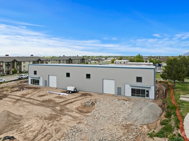
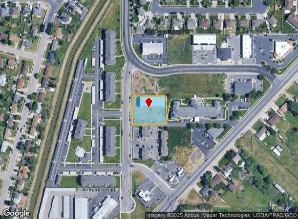
Property Record
4608 S 3500 W, West Haven, UT 84401

NEARBY LISTINGS FOR SALE OR LEASE
Property Detail
4608 S 3500 W
Ogden-Clearfield, UT
Sodenkamp Subdivision Amended Lot 5
08-458-0002
ALL OF LOT 6, SODENKAMP SUBDIVISION AMENDED LOT 5, WEST HAVEN CITY, WEBER COUNTY, UTAH.
Publicstorage
Weber
X
Utah
49057C0425F
5-6
2025
0.91 AC
2025
Davis North
201900
Salt Lake City
9,000 SF
DEMOGRAPHICS near 4608 S 3500 W
1 Mile
3 Mile
5 Mile
2024 Total Population
14,779
78,784
146,794
2029 Population
16,081
84,494
157,225
Pop Growth 2024-2029
+ 8.81%
+ 7.25%
+ 7.11%
Average Age
34
35
35
2024 Total Households
4,523
25,092
46,795
HH Growth 2024-2029
+ 8.98%
+ 7.36%
+ 7.27%
Median Household Inc
$91,129
$83,648
$80,660
Avg Household Size
3.20
3.10
3.10
2024 Avg HH Vehicles
3.00
2.00
2.00
Median Home Value
$344,208
$359,297
$364,331
Median Year Built
1997
1993
1991
Nearby Places
Map Layers
Map Styles
 Street
 Aerial
- Restaurants
- Banks
- Shops
- Fitness
- Groceries
PUBLIC TRANSPORTATION
COMMUTER RAIL
Roy (FrontRunner North - Utah Transit Authority (UTA))
DRIVE
WALK
Distance
Roy (FrontRunner North - Utah Transit Authority (UTA))
4 min
2.1 mi
Ogden (FrontRunner North - Utah Transit Authority (UTA))
DRIVE
WALK
Distance
Ogden (FrontRunner North - Utah Transit Authority (UTA))
12 min
6.4 mi
AIRPORT
Salt Lake City International
DRIVE
WALK
Distance
Salt Lake City International
46 min
37.1 mi
Freight Ports
Port of Stockton
DRIVE
WALK
Distance
Port of Stockton
747 min
727.5 mi
SALE & LEASE HISTORY
LISTING DATE
SALE/LEASE

May 20, 2024
For Lease
Nearby Properties
Address
Land Use
TOTAL SIZE
Lot Size
Zoning
Address
Land Use
TOTAL SIZE
Lot Size
Zoning
35,219 SF
58.98 AC
Address
Land Use
TOTAL SIZE
Lot Size
Zoning
7,492 SF
8.96 AC
Address
Land Use
TOTAL SIZE
Lot Size
Zoning
71,940 SF
11 AC
Address
Land Use
TOTAL SIZE
Lot Size
Zoning
8,580 SF
6.40 AC
Address
Land Use
TOTAL SIZE
Lot Size
Zoning
223,079 SF
22.55 AC
Address
Land Use
TOTAL SIZE
Lot Size
Zoning
23,932 SF
5.53 AC
Address
Land Use
TOTAL SIZE
Lot Size
Zoning
139,574 SF
9.30 AC
Address
Land Use
TOTAL SIZE
Lot Size
Zoning
17,220 SF
218.11 AC
Address
Land Use
TOTAL SIZE
Lot Size
Zoning
62,246 SF
5.37 AC
PZ
Address
Land Use
TOTAL SIZE
Lot Size
Zoning
140,015 SF
12.14 AC
PZ
Address
Land Use
TOTAL SIZE
Lot Size
Zoning
88,125 SF
7.17 AC
PZ
Address
Land Use
TOTAL SIZE
Lot Size
Zoning
58,287 SF
5.18 AC
Address
Land Use
TOTAL SIZE
Lot Size
Zoning
50,440 SF
5.26 AC
Address
Land Use
TOTAL SIZE
Lot Size
Zoning
50,432 SF
3.86 AC
R115
Address
Land Use
TOTAL SIZE
Lot Size
Zoning
45,772 SF
5 AC
Address
Land Use
TOTAL SIZE
Lot Size
Zoning
1,620 SF
3.74 AC
Address
Land Use
TOTAL SIZE
Lot Size
Zoning
20,010 SF
8.33 AC
Address
Land Use
TOTAL SIZE
Lot Size
Zoning
45,160 SF
10.93 AC
Address
Land Use
TOTAL SIZE
Lot Size
Zoning
33,818 SF
3.27 AC
Address
Land Use
TOTAL SIZE
Lot Size
Zoning
95,394 SF
8.83 AC
Address
Land Use
TOTAL SIZE
Lot Size
Zoning
56,500 SF
8.02 AC
Address
Land Use
TOTAL SIZE
Lot Size
Zoning
22,656 SF
5.42 AC
PZ
Address
Land Use
TOTAL SIZE
Lot Size
Zoning
1,960 SF
148.41 AC
Address
Land Use
TOTAL SIZE
Lot Size
Zoning
72,653 SF
8.78 AC
C2
Address
Land Use
TOTAL SIZE
Lot Size
Zoning
104,709 SF
2.28 AC
The World's #1 Commercial Real Estate Marketplace
Connect with us
© 2025 CoStar Group
The information above has been obtained from sources believed reliable. While we do not doubt its accuracy we have not verified it and make no guarantee, warranty or representation about it. It is your responsibility to independently confirm its accuracy and completeness. Any projections, opinions, assumptions, or estimates used are for example only and do not represent the current or future performance of the property. The value of this transaction to you depends on tax and other factors which should be evaluated by your tax, financial, and legal advisors. You and your advisors should conduct a careful, independent investigation of the property to determine to your satisfaction the suitability of the property for your needs.