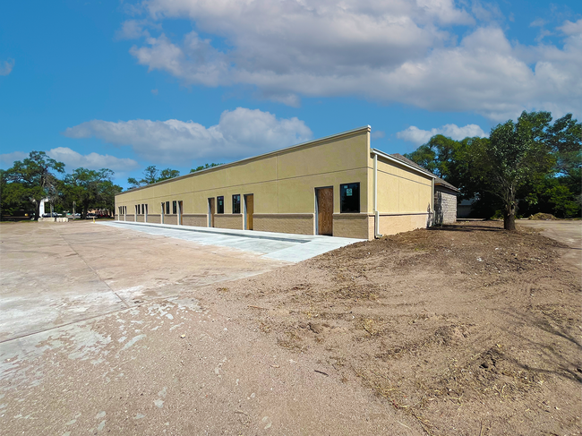
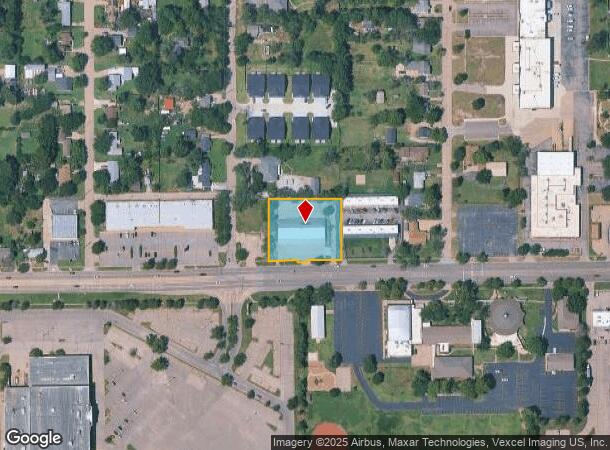
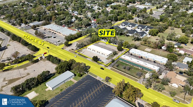
Property Record
4608 W Maple St, Wichita, KS 67209
Current Lease Availabilities
NEARBY LISTINGS FOR SALE OR LEASE
Property Detail
4608 W Maple St
Wichita, KS
Subd No.: D01
136-23-0-43-02-010.00
LOT 15 EXC W 78 FT S 210 FT & EXC N 156 FT & EXC CC 78C 2366 FOR ST MC COMAS ACRES ADD.
Warehouse
Sedgwick
X
Kansas
20173C0342G
15
2024
0.99 AC
2025
Southwest
009200
Wichita
8,984 SF
DEMOGRAPHICS near 4608 W Maple St
1 Mile
3 Mile
5 Mile
2024 Total Population
6,078
65,252
192,380
2029 Population
6,205
66,674
196,475
Pop Growth 2024-2029
+ 2.09%
+ 2.18%
+ 2.13%
Average Age
38
39
39
2024 Total Households
2,512
28,976
78,400
HH Growth 2024-2029
+ 1.99%
+ 2.21%
+ 2.21%
Median Household Inc
$44,566
$46,412
$53,084
Avg Household Size
2.20
2.10
2.30
2024 Avg HH Vehicles
2.00
2.00
2.00
Median Home Value
$93,363
$127,612
$144,195
Median Year Built
1969
1965
1970
Nearby Places
- Restaurants
- Banks
- Shops
- Fitness
- Groceries
PUBLIC TRANSPORTATION
AIRPORT
Wichita Dwight D Eisenhower Ntl
DRIVE
WALK
Distance
Wichita Dwight D Eisenhower Ntl
9 min
3.6 mi
Nearby Properties
Address
Land Use
TOTAL SIZE
Lot Size
Zoning
Address
Land Use
TOTAL SIZE
Lot Size
Zoning
1,675,141 SF
1,753.52 AC
LI
Address
Land Use
TOTAL SIZE
Lot Size
Zoning
216,196 SF
65.60 AC
SF-5
Address
Land Use
TOTAL SIZE
Lot Size
Zoning
154,716 SF
12.18 AC
LC
Address
Land Use
TOTAL SIZE
Lot Size
Zoning
456,792 SF
155.67 AC
LI
Address
Land Use
TOTAL SIZE
Lot Size
Zoning
303,559 SF
123.23 AC
SF-5
Address
Land Use
TOTAL SIZE
Lot Size
Zoning
203,580 SF
15.51 AC
B
Address
Land Use
TOTAL SIZE
Lot Size
Zoning
109,743 SF
6.10 AC
CBD
Address
Land Use
TOTAL SIZE
Lot Size
Zoning
84,959 SF
2 AC
LI
Address
Land Use
TOTAL SIZE
Lot Size
Zoning
328,487 SF
25.95 AC
MF-29
Address
Land Use
TOTAL SIZE
Lot Size
Zoning
108,283 SF
14.80 AC
SF-5
Address
Land Use
TOTAL SIZE
Lot Size
Zoning
192,027 SF
117.94 AC
SF-20,GC,L
Address
Land Use
TOTAL SIZE
Lot Size
Zoning
62,535 SF
8.34 AC
B
Address
Land Use
TOTAL SIZE
Lot Size
Zoning
169,321 SF
14.61 AC
U
Address
Land Use
TOTAL SIZE
Lot Size
Zoning
79,041 SF
19.51 AC
LC
Address
Land Use
TOTAL SIZE
Lot Size
Zoning
89,057 SF
18.91 AC
B
Address
Land Use
TOTAL SIZE
Lot Size
Zoning
35,097 SF
2.82 AC
U
Address
Land Use
TOTAL SIZE
Lot Size
Zoning
172,486 SF
25.68 AC
SF-5
Address
Land Use
TOTAL SIZE
Lot Size
Zoning
167,923 SF
18.01 AC
SF-5
Address
Land Use
TOTAL SIZE
Lot Size
Zoning
55,930 SF
10.28 AC
LI
Address
Land Use
TOTAL SIZE
Lot Size
Zoning
98,677 SF
5.62 AC
TF-3
Address
Land Use
TOTAL SIZE
Lot Size
Zoning
211,379 SF
23.34 AC
SF-5
Address
Land Use
TOTAL SIZE
Lot Size
Zoning
143,704 SF
19.22 AC
SF-5
Address
Land Use
TOTAL SIZE
Lot Size
Zoning
68,468 SF
7.17 AC
B,SF-5,GO
Address
Land Use
TOTAL SIZE
Lot Size
Zoning
136,717 SF
11.18 AC
SF-5
Address
Land Use
TOTAL SIZE
Lot Size
Zoning
134,475 SF
19.87 AC
LI
Address
Land Use
TOTAL SIZE
Lot Size
Zoning
79,278 SF
5.24 AC
GO
Address
Land Use
TOTAL SIZE
Lot Size
Zoning
68,970 SF
1.80 AC
SF-5
Address
Land Use
TOTAL SIZE
Lot Size
Zoning
193,680 SF
4.31 AC
LI
Address
Land Use
TOTAL SIZE
Lot Size
Zoning
56,081 SF
3.75 AC
U
Address
Land Use
TOTAL SIZE
Lot Size
Zoning
72,904 SF
4.25 AC
PUD
The World's #1 Commercial Real Estate Marketplace
Connect with us
© 2025 CoStar Group
The information above has been obtained from sources believed reliable. While we do not doubt its accuracy we have not verified it and make no guarantee, warranty or representation about it. It is your responsibility to independently confirm its accuracy and completeness. Any projections, opinions, assumptions, or estimates used are for example only and do not represent the current or future performance of the property. The value of this transaction to you depends on tax and other factors which should be evaluated by your tax, financial, and legal advisors. You and your advisors should conduct a careful, independent investigation of the property to determine to your satisfaction the suitability of the property for your needs.