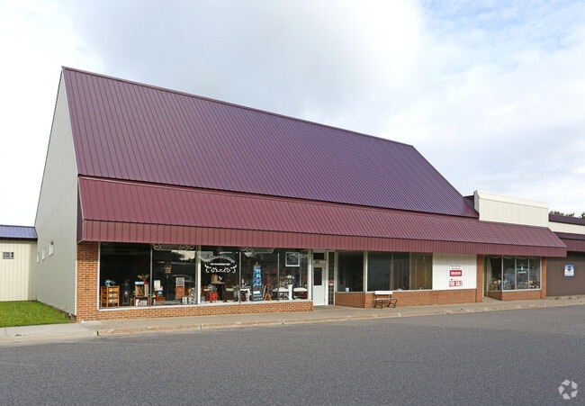
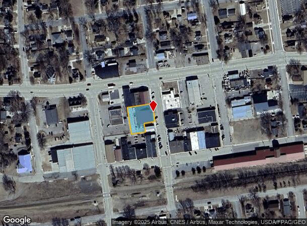
Property Record
461 3Rd St N, Dassel, MN 55325

NEARBY LISTINGS FOR SALE OR LEASE
-
-
View all Dassel listings for sale on LoopNet.com
Property Detail
461 3Rd St N
Other Market Areas
City Of Dassel
23-0090000
LT 4 & 5 EX E60' LT 5
Commercialnec
Meeker
X
Minnesota
27093C0375C
3
2025
0.41 AC
2025
Minnesota Central Area
560100
DEMOGRAPHICS near 461 3Rd St N
1 Mile
3 Mile
5 Mile
2024 Total Population
1,825
2,870
4,785
2029 Population
1,873
2,938
4,910
Pop Growth 2024-2029
+ 2.63%
+ 2.37%
+ 2.61%
Average Age
41
41
41
2024 Total Households
690
1,079
1,799
HH Growth 2024-2029
+ 2.61%
+ 2.32%
+ 2.50%
Median Household Inc
$63,750
$72,526
$78,230
Avg Household Size
2.40
2.50
2.50
2024 Avg HH Vehicles
2.00
2.00
2.00
Median Home Value
$223,958
$257,446
$285,463
Median Year Built
1983
1983
1982
Nearby Places
Map Layers
Map Styles
 Street
 Aerial
- Restaurants
- Banks
- Shops
- Fitness
- Groceries
SALE & LEASE HISTORY
LISTING DATE
SALE/LEASE

Sep 24, 2016
For Sale
Oct 31, 2016
For Sale
Jun 28, 2017
For Sale
Jun 16, 2017
For Sale
Jan 03, 2017
For Sale
Feb 15, 2019
For Sale
Nearby Properties
Address
Land Use
TOTAL SIZE
Lot Size
Zoning
Address
Land Use
TOTAL SIZE
Lot Size
Zoning
3.23 AC
Address
Land Use
TOTAL SIZE
Lot Size
Zoning
8.80 AC
Address
Land Use
TOTAL SIZE
Lot Size
Zoning
9.98 AC
Address
Land Use
TOTAL SIZE
Lot Size
Zoning
3.40 AC
Address
Land Use
TOTAL SIZE
Lot Size
Zoning
7.73 AC
Address
Land Use
TOTAL SIZE
Lot Size
Zoning
1,978 SF
80 AC
Address
Land Use
TOTAL SIZE
Lot Size
Zoning
4.50 AC
Address
Land Use
TOTAL SIZE
Lot Size
Zoning
1.40 AC
Address
Land Use
TOTAL SIZE
Lot Size
Zoning
153.07 AC
Address
Land Use
TOTAL SIZE
Lot Size
Zoning
50.70 AC
Address
Land Use
TOTAL SIZE
Lot Size
Zoning
1.13 AC
Address
Land Use
TOTAL SIZE
Lot Size
Zoning
1,308 SF
1.61 AC
Address
Land Use
TOTAL SIZE
Lot Size
Zoning
4.86 AC
Address
Land Use
TOTAL SIZE
Lot Size
Zoning
1.13 AC
Address
Land Use
TOTAL SIZE
Lot Size
Zoning
0.57 AC
Address
Land Use
TOTAL SIZE
Lot Size
Zoning
20.68 AC
Address
Land Use
TOTAL SIZE
Lot Size
Zoning
0.48 AC
Address
Land Use
TOTAL SIZE
Lot Size
Zoning
21,600 SF
1.87 AC
Address
Land Use
TOTAL SIZE
Lot Size
Zoning
1.60 AC
Address
Land Use
TOTAL SIZE
Lot Size
Zoning
2.50 AC
Address
Land Use
TOTAL SIZE
Lot Size
Zoning
4,160 SF
3 AC
Address
Land Use
TOTAL SIZE
Lot Size
Zoning
788 SF
0.32 AC
Address
Land Use
TOTAL SIZE
Lot Size
Zoning
3.27 AC
Address
Land Use
TOTAL SIZE
Lot Size
Zoning
1.29 AC
Address
Land Use
TOTAL SIZE
Lot Size
Zoning
0.11 AC
Address
Land Use
TOTAL SIZE
Lot Size
Zoning
1.10 AC
Address
Land Use
TOTAL SIZE
Lot Size
Zoning
0.39 AC
Address
Land Use
TOTAL SIZE
Lot Size
Zoning
0.21 AC
Address
Land Use
TOTAL SIZE
Lot Size
Zoning
Address
Land Use
TOTAL SIZE
Lot Size
Zoning
2.75 AC
The World's #1 Commercial Real Estate Marketplace
Connect with us
© 2026 CoStar Group
The information above has been obtained from sources believed reliable. While we do not doubt its accuracy we have not verified it and make no guarantee, warranty or representation about it. It is your responsibility to independently confirm its accuracy and completeness. Any projections, opinions, assumptions, or estimates used are for example only and do not represent the current or future performance of the property. The value of this transaction to you depends on tax and other factors which should be evaluated by your tax, financial, and legal advisors. You and your advisors should conduct a careful, independent investigation of the property to determine to your satisfaction the suitability of the property for your needs.