Property Record
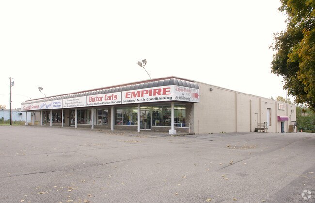
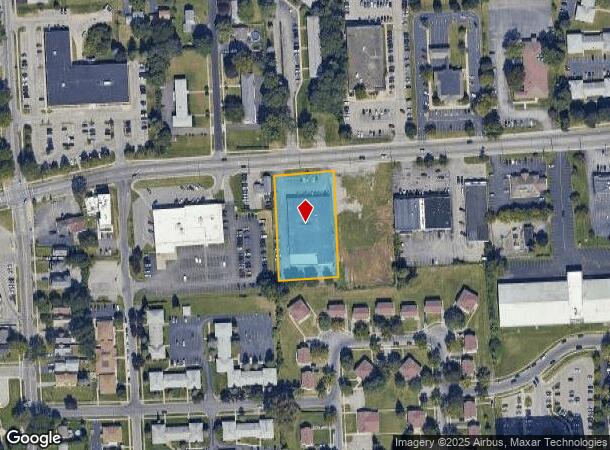
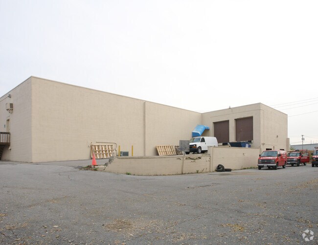
461 E Ridge Rd, Rochester, NY 14621
NEARBY LISTINGS FOR SALE OR LEASE
Property Detail
461 E Ridge Rd
263400-091-100-0001-004-000
0036-14-07
Storesoffices
Monroe
X
New York
36055C0203G
4.000
2025
1.20 AC
2024
Greater Rochester
010400
Rochester
18,544 SF
Rochester, NY
DEMOGRAPHICS near 461 E Ridge Rd
1 Mile
3 Mile
5 Mile
2024 Total Population
20,181
153,143
313,801
2029 Population
19,840
150,956
308,929
Pop Growth 2024-2029
(1.69%)
(1.43%)
(1.55%)
Average Age
40
38
39
2024 Total Households
8,763
64,593
138,875
HH Growth 2024-2029
(1.71%)
(1.34%)
(1.58%)
Median Household Inc
$39,527
$43,957
$51,300
Avg Household Size
2.20
2.30
2.20
2024 Avg HH Vehicles
1.00
1.00
1.00
Median Home Value
$126,036
$114,999
$134,985
Median Year Built
1955
1949
1950
Nearby Places
- Restaurants
- Banks
- Shops
- Fitness
- Groceries
PUBLIC TRANSPORTATION
COMMUTER RAIL
Rochester (Empire Service - VIA Rail, Lake Shore Limited - VIA Rail, Maple Leaf - VIA Rail, Toronto - New York - VIA Rail)
DRIVE
WALK
Distance
Rochester (Empire Service - VIA Rail, Lake Shore Limited - VIA Rail, Maple Leaf - VIA Rail, Toronto - New York - VIA Rail)
5 min
2.5 mi
AIRPORT
Frederick Douglass/Greater Rochester International
DRIVE
WALK
Distance
Frederick Douglass/Greater Rochester International
13 min
7.5 mi
Freight Ports
Albany, NY Port
DRIVE
WALK
Distance
Albany, NY Port
271 min
230.0 mi
Nearby Properties
Address
Land Use
TOTAL SIZE
Lot Size
Zoning
Address
Land Use
TOTAL SIZE
Lot Size
Zoning
847,728 SF
41.57 AC
Address
Land Use
TOTAL SIZE
Lot Size
Zoning
0.47 AC
Address
Land Use
TOTAL SIZE
Lot Size
Zoning
0.13 AC
Address
Land Use
TOTAL SIZE
Lot Size
Zoning
270,150 SF
34.40 AC
02 - SINGL
Address
Land Use
TOTAL SIZE
Lot Size
Zoning
13.10 AC
Address
Land Use
TOTAL SIZE
Lot Size
Zoning
373,200 SF
5.42 AC
Address
Land Use
TOTAL SIZE
Lot Size
Zoning
178,321 SF
3.10 AC
Address
Land Use
TOTAL SIZE
Lot Size
Zoning
0.01 AC
Address
Land Use
TOTAL SIZE
Lot Size
Zoning
302,484 SF
2.53 AC
Address
Land Use
TOTAL SIZE
Lot Size
Zoning
473,876 SF
1.49 AC
Address
Land Use
TOTAL SIZE
Lot Size
Zoning
342,266 SF
1.44 AC
Address
Land Use
TOTAL SIZE
Lot Size
Zoning
7,200 SF
12.35 AC
Address
Land Use
TOTAL SIZE
Lot Size
Zoning
0.41 AC
Address
Land Use
TOTAL SIZE
Lot Size
Zoning
0.01 AC
Address
Land Use
TOTAL SIZE
Lot Size
Zoning
416,083 SF
0.94 AC
Address
Land Use
TOTAL SIZE
Lot Size
Zoning
323,264 SF
21.06 AC
06 - INDUS
Address
Land Use
TOTAL SIZE
Lot Size
Zoning
0.01 AC
Address
Land Use
TOTAL SIZE
Lot Size
Zoning
491,375 SF
5.90 AC
Address
Land Use
TOTAL SIZE
Lot Size
Zoning
161,812 SF
5.18 AC
06 - INDUS
Address
Land Use
TOTAL SIZE
Lot Size
Zoning
273,900 SF
0.74 AC
Address
Land Use
TOTAL SIZE
Lot Size
Zoning
336,447 SF
1.38 AC
Address
Land Use
TOTAL SIZE
Lot Size
Zoning
335,918 SF
10.19 AC
Address
Land Use
TOTAL SIZE
Lot Size
Zoning
151,590 SF
1.14 AC
Address
Land Use
TOTAL SIZE
Lot Size
Zoning
233,579 SF
1.13 AC
Address
Land Use
TOTAL SIZE
Lot Size
Zoning
410,400 SF
2.88 AC
Address
Land Use
TOTAL SIZE
Lot Size
Zoning
193,892 SF
18.62 AC
05 - COMME
Address
Land Use
TOTAL SIZE
Lot Size
Zoning
261,960 SF
3.73 AC
Address
Land Use
TOTAL SIZE
Lot Size
Zoning
203,306 SF
3.91 AC
Address
Land Use
TOTAL SIZE
Lot Size
Zoning
1.06 AC
Address
Land Use
TOTAL SIZE
Lot Size
Zoning
742,711 SF
56.05 AC
The World's #1 Commercial Real Estate Marketplace
Connect with us
© 2025 CoStar Group
The information above has been obtained from sources believed reliable. While we do not doubt its accuracy we have not verified it and make no guarantee, warranty or representation about it. It is your responsibility to independently confirm its accuracy and completeness. Any projections, opinions, assumptions, or estimates used are for example only and do not represent the current or future performance of the property. The value of this transaction to you depends on tax and other factors which should be evaluated by your tax, financial, and legal advisors. You and your advisors should conduct a careful, independent investigation of the property to determine to your satisfaction the suitability of the property for your needs.