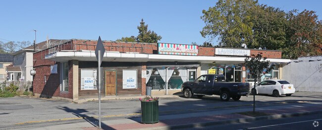
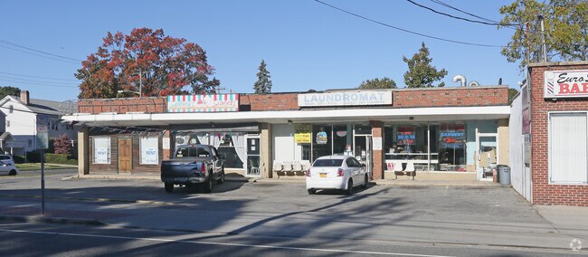
Property Record
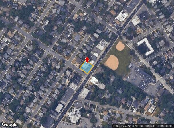
461 Hempstead Ave, West Hempstead, NY 11552
NEARBY LISTINGS FOR SALE OR LEASE
Property Detail
461 Hempstead Ave
Nassau County-Suffolk County, NY
Hempstead Park Gardens
2089-35-345-00-0006-0
6-10
Commercialnec
Nassau
X
New York
36059C0210G
6
2025
0.23 AC
2025
Central Nassau
406001
Long Island (New York)
8,000 SF
DEMOGRAPHICS near 461 Hempstead Ave
1 Mile
3 Mile
5 Mile
2024 Total Population
23,902
246,602
688,464
2029 Population
23,356
241,123
668,011
Pop Growth 2024-2029
(2.28%)
(2.22%)
(2.97%)
Average Age
41
40
41
2024 Total Households
7,424
76,111
215,225
HH Growth 2024-2029
(2.38%)
(2.28%)
(3.10%)
Median Household Inc
$137,682
$118,146
$115,956
Avg Household Size
3.10
3.10
3.10
2024 Avg HH Vehicles
2.00
2.00
2.00
Median Home Value
$644,308
$639,223
$640,106
Median Year Built
1951
1951
1951
Nearby Places
- Restaurants
- Banks
- Shops
- Fitness
- Groceries
PUBLIC TRANSPORTATION
COMMUTER RAIL
Hempstead Gardens Station (West Hempstead Branch - Long Island Rail Road)
DRIVE
WALK
Distance
Hempstead Gardens Station (West Hempstead Branch - Long Island Rail Road)
2 min
10 min
0.5 mi
West Hempstead Station (West Hempstead Branch - Long Island Rail Road)
DRIVE
WALK
Distance
West Hempstead Station (West Hempstead Branch - Long Island Rail Road)
1 min
15 min
0.7 mi
AIRPORT
John F Kennedy International
DRIVE
WALK
Distance
John F Kennedy International
18 min
11.2 mi
LaGuardia
DRIVE
WALK
Distance
LaGuardia
28 min
15.7 mi
Westchester County
DRIVE
WALK
Distance
Westchester County
57 min
37.2 mi
Freight Ports
NY - Red Hook Container Terminal
DRIVE
WALK
Distance
NY - Red Hook Container Terminal
39 min
22.6 mi
Nearby Properties
Address
Land Use
TOTAL SIZE
Lot Size
Zoning
Address
Land Use
TOTAL SIZE
Lot Size
Zoning
5,322,666 SF
86.10 AC
Address
Land Use
TOTAL SIZE
Lot Size
Zoning
202.54 AC
Address
Land Use
TOTAL SIZE
Lot Size
Zoning
1,197,283 SF
64.50 AC
Address
Land Use
TOTAL SIZE
Lot Size
Zoning
574,353 SF
65 AC
Address
Land Use
TOTAL SIZE
Lot Size
Zoning
186 AC
Address
Land Use
TOTAL SIZE
Lot Size
Zoning
962,971 SF
18.90 AC
Address
Land Use
TOTAL SIZE
Lot Size
Zoning
29,224 SF
1.33 AC
Address
Land Use
TOTAL SIZE
Lot Size
Zoning
277,200 SF
21.03 AC
Address
Land Use
TOTAL SIZE
Lot Size
Zoning
130,720 SF
48.60 AC
Address
Land Use
TOTAL SIZE
Lot Size
Zoning
46,404 SF
38.43 AC
Address
Land Use
TOTAL SIZE
Lot Size
Zoning
116,998 SF
26.35 AC
Address
Land Use
TOTAL SIZE
Lot Size
Zoning
29,998 SF
22.49 AC
Address
Land Use
TOTAL SIZE
Lot Size
Zoning
76.10 AC
Address
Land Use
TOTAL SIZE
Lot Size
Zoning
83.42 AC
Address
Land Use
TOTAL SIZE
Lot Size
Zoning
115.42 AC
Address
Land Use
TOTAL SIZE
Lot Size
Zoning
126,558 SF
12.76 AC
Address
Land Use
TOTAL SIZE
Lot Size
Zoning
441,888 SF
22.09 AC
Address
Land Use
TOTAL SIZE
Lot Size
Zoning
23,148 SF
18.67 AC
Address
Land Use
TOTAL SIZE
Lot Size
Zoning
293,443 SF
21.86 AC
Address
Land Use
TOTAL SIZE
Lot Size
Zoning
252,032 SF
4.72 AC
Address
Land Use
TOTAL SIZE
Lot Size
Zoning
20,670 SF
6.62 AC
Address
Land Use
TOTAL SIZE
Lot Size
Zoning
88,011 SF
15.01 AC
Address
Land Use
TOTAL SIZE
Lot Size
Zoning
1,620 SF
0.14 AC
Address
Land Use
TOTAL SIZE
Lot Size
Zoning
170,753 SF
26.64 AC
Address
Land Use
TOTAL SIZE
Lot Size
Zoning
86,903 SF
29.84 AC
Address
Land Use
TOTAL SIZE
Lot Size
Zoning
63.32 AC
Address
Land Use
TOTAL SIZE
Lot Size
Zoning
502,830 SF
1.79 AC
Address
Land Use
TOTAL SIZE
Lot Size
Zoning
140,992 SF
12.07 AC
Address
Land Use
TOTAL SIZE
Lot Size
Zoning
154,268 SF
5.94 AC
Address
Land Use
TOTAL SIZE
Lot Size
Zoning
74,813 SF
4.56 AC
The World's #1 Commercial Real Estate Marketplace
Connect with us
© 2025 CoStar Group
The information above has been obtained from sources believed reliable. While we do not doubt its accuracy we have not verified it and make no guarantee, warranty or representation about it. It is your responsibility to independently confirm its accuracy and completeness. Any projections, opinions, assumptions, or estimates used are for example only and do not represent the current or future performance of the property. The value of this transaction to you depends on tax and other factors which should be evaluated by your tax, financial, and legal advisors. You and your advisors should conduct a careful, independent investigation of the property to determine to your satisfaction the suitability of the property for your needs.