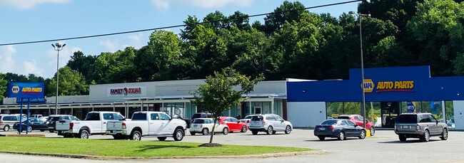
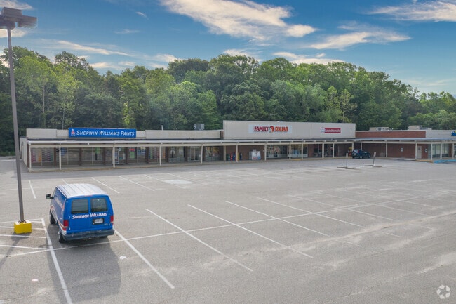
Property Record
461 Merrimac Trl, Williamsburg, VA 23185
Current Lease Availabilities
NEARBY LISTINGS FOR SALE OR LEASE
Property Detail
461 Merrimac Trl
F14B-2887-2900
Dana T W Etal Sub
Stripcommercialcenter
DANA T W ETAL SUB PT PAR 1
X
York
51095C0143D
Virginia
2024
1.38 AC
2025
Williamsburg
051100
Hampton Roads
18,388 SF
Virginia Beach-Norfolk-Newport News, VA-NC
DEMOGRAPHICS near 461 Merrimac Trl
1 Mile
3 Mile
5 Mile
2024 Total Population
8,227
32,763
58,595
2029 Population
8,837
35,583
63,810
Pop Growth 2024-2029
+ 7.41%
+ 8.61%
+ 8.90%
Average Age
39
40
42
2024 Total Households
3,302
11,912
22,978
HH Growth 2024-2029
+ 8.69%
+ 9.89%
+ 9.73%
Median Household Inc
$75,768
$83,283
$84,326
Avg Household Size
2.40
2.30
2.30
2024 Avg HH Vehicles
2.00
2.00
2.00
Median Home Value
$274,267
$360,213
$371,922
Median Year Built
1983
1987
1991
Nearby Places
- Restaurants
- Banks
- Shops
- Fitness
- Groceries
PUBLIC TRANSPORTATION
COMMUTER RAIL
Williamsburg Amtrak Station (Northeast Regional - Amtrak)
DRIVE
WALK
Distance
Williamsburg Amtrak Station (Northeast Regional - Amtrak)
6 min
2.2 mi
AIRPORT
Newport News/Williamsburg International
DRIVE
WALK
Distance
Newport News/Williamsburg International
26 min
16.0 mi
Freight Ports
Virginia Port Authority - Newport News
DRIVE
WALK
Distance
Virginia Port Authority - Newport News
39 min
30.1 mi
Nearby Properties
Address
Land Use
TOTAL SIZE
Lot Size
Zoning
Address
Land Use
TOTAL SIZE
Lot Size
Zoning
55,136 SF
348.94 AC
WM (WILLIA
Address
Land Use
TOTAL SIZE
Lot Size
Zoning
1,938,121 SF
81.88 AC
M2 GENERAL
Address
Land Use
TOTAL SIZE
Lot Size
Zoning
83,748 SF
B-3 (GENER
Address
Land Use
TOTAL SIZE
Lot Size
Zoning
3,696 SF
222 AC
ECONOMIC O
Address
Land Use
TOTAL SIZE
Lot Size
Zoning
87,083 SF
55.74 AC
WM (WILLIA
Address
Land Use
TOTAL SIZE
Lot Size
Zoning
88,000 SF
11.48 AC
MS (MUSEUM
Address
Land Use
TOTAL SIZE
Lot Size
Zoning
71,980 SF
6 AC
ED-2 (ECON
Address
Land Use
TOTAL SIZE
Lot Size
Zoning
301,801 SF
13.49 AC
PLANNED DE
Address
Land Use
TOTAL SIZE
Lot Size
Zoning
10,144 SF
87.57 AC
R5 MULTIFA
Address
Land Use
TOTAL SIZE
Lot Size
Zoning
52,774 SF
9.07 AC
PLANNED DE
Address
Land Use
TOTAL SIZE
Lot Size
Zoning
109,842 SF
17.34 AC
ED-C (ECON
Address
Land Use
TOTAL SIZE
Lot Size
Zoning
109,045 SF
18.31 AC
RS-2 (SING
Address
Land Use
TOTAL SIZE
Lot Size
Zoning
164,647 SF
34.11 AC
MS (MUSEUM
Address
Land Use
TOTAL SIZE
Lot Size
Zoning
182,259 SF
3.60 AC
B-1 (DOWNT
Address
Land Use
TOTAL SIZE
Lot Size
Zoning
2,387.90 AC
PL PUBLIC
Address
Land Use
TOTAL SIZE
Lot Size
Zoning
501.93 AC
WM (WILLIA
Address
Land Use
TOTAL SIZE
Lot Size
Zoning
32,730 SF
4.89 AC
ED-2 (ECON
Address
Land Use
TOTAL SIZE
Lot Size
Zoning
113,000 SF
22.20 AC
WM (WILLIA
Address
Land Use
TOTAL SIZE
Lot Size
Zoning
14,448 SF
6.94 AC
WM (WILLIA
Address
Land Use
TOTAL SIZE
Lot Size
Zoning
167,811 SF
51.70 AC
PUDR PLANN
Address
Land Use
TOTAL SIZE
Lot Size
Zoning
58,107 SF
14.62 AC
ED-C (ECON
Address
Land Use
TOTAL SIZE
Lot Size
Zoning
36,545 SF
11.48 AC
MS (MUSEUM
Address
Land Use
TOTAL SIZE
Lot Size
Zoning
55,122 SF
11.33 AC
LB-1 (DOWN
Address
Land Use
TOTAL SIZE
Lot Size
Zoning
96,955 SF
4.12 AC
ED-C (ECON
Address
Land Use
TOTAL SIZE
Lot Size
Zoning
149,179 SF
3 AC
ED-C (ECON
Address
Land Use
TOTAL SIZE
Lot Size
Zoning
53,014 SF
34.74 AC
MS (MUSEUM
Address
Land Use
TOTAL SIZE
Lot Size
Zoning
660 SF
538.28 AC
RESOURCE C
Address
Land Use
TOTAL SIZE
Lot Size
Zoning
12,444 SF
26.96 AC
RM-2 (MULT
Address
Land Use
TOTAL SIZE
Lot Size
Zoning
154,809 SF
7.31 AC
PLANNED DE
Address
Land Use
TOTAL SIZE
Lot Size
Zoning
9,528 SF
4.78 AC
ED-2 (ECON
The World's #1 Commercial Real Estate Marketplace
Connect with us
© 2025 CoStar Group
The information above has been obtained from sources believed reliable. While we do not doubt its accuracy we have not verified it and make no guarantee, warranty or representation about it. It is your responsibility to independently confirm its accuracy and completeness. Any projections, opinions, assumptions, or estimates used are for example only and do not represent the current or future performance of the property. The value of this transaction to you depends on tax and other factors which should be evaluated by your tax, financial, and legal advisors. You and your advisors should conduct a careful, independent investigation of the property to determine to your satisfaction the suitability of the property for your needs.