Property Record
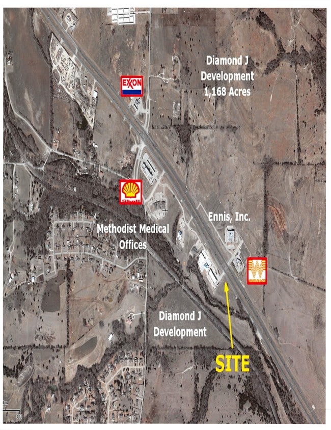
4610 E Highway 287, Midlothian, TX 76065

Property Detail
4610 E Highway 287
Dallas-Fort Worth-Arlington, TX
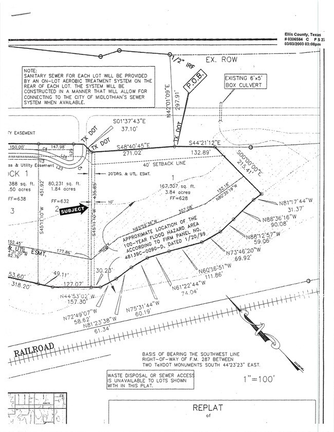
LOT 1 BLK 1 WALNUT GROVE CENTER SOUTH 3.84 AC
223978
ELLIS
Commercialnec
Texas
AE The base floodplain where base flood elevations are provided. AE Zones are now used on new format FIRMs instead of A1-A30 Zones.
1
2024
3.84 AC
2025
Ellis County
060801
Dallas/Ft Worth
3,080 SF
NEARBY LISTINGS FOR SALE OR LEASE
DEMOGRAPHICS near 4610 E Highway 287
1 mile
3 mile
5 mile
2025 Total Population
1,055
18,450
57,224
2030 Population
1,262
21,722
67,148
Pop Growth 2025-2030
+ 19.62%
+ 17.73%
+ 17.34%
Average Age
39
38
38
2025 Total Households
369
6,045
19,031
HH Growth 2025-2030
+ 19.78%
+ 17.98%
+ 17.52%
Median Household Inc
$88,888
$119,912
$119,711
Avg Household Size
2.80
3.00
3.00
2025 Avg HH Vehicles
2.00
2.00
2.00
Median Home Value
$485,155
$461,332
$456,381
Median Year Built
2010
2008
2008
Nearby Places
Map Layers
Map Styles
 Street
 Aerial
Transit
 Traffic
 Biking
Places
Listings with unknown addresses are not visible on the map
- Restaurants
- Banks
- Shops
- Fitness
- Groceries
PUBLIC TRANSPORTATION
AIRPORT
Dallas Love Field
Drive
Walk
Distance
Dallas Love Field
47 min
33.9 mi
Dallas-Fort Worth International
Drive
Walk
Distance
Dallas-Fort Worth International
51 min
39.0 mi
SALE & LEASE HISTORY
LISTING DATE
SALE/LEASE

Sep 24, 2016
For Sale
Nearby Properties
Address
Land Use
TOTAL SIZE
Lot Size
Zoning
Address
Land Use
TOTAL SIZE
Lot Size
Zoning
427,771 SF
101.40 AC
Address
Land Use
TOTAL SIZE
Lot Size
Zoning
176,817 SF
30.71 AC
Address
Land Use
TOTAL SIZE
Lot Size
Zoning
28,974 SF
47.07 AC
Address
Land Use
TOTAL SIZE
Lot Size
Zoning
98,001 SF
14.51 AC
Address
Land Use
TOTAL SIZE
Lot Size
Zoning
70,066 SF
23.14 AC
Address
Land Use
TOTAL SIZE
Lot Size
Zoning
90,377 SF
27.54 AC
Address
Land Use
TOTAL SIZE
Lot Size
Zoning
90,000 SF
12.20 AC
Address
Land Use
TOTAL SIZE
Lot Size
Zoning
117,249 SF
30.65 AC
Address
Land Use
TOTAL SIZE
Lot Size
Zoning
30,354 SF
17.33 AC
Address
Land Use
TOTAL SIZE
Lot Size
Zoning
120,810 SF
3.01 AC
Address
Land Use
TOTAL SIZE
Lot Size
Zoning
45,000 SF
Address
Land Use
TOTAL SIZE
Lot Size
Zoning
34,771 SF
19.08 AC
Address
Land Use
TOTAL SIZE
Lot Size
Zoning
46,502 SF
19.38 AC
Address
Land Use
TOTAL SIZE
Lot Size
Zoning
21,740 SF
77.39 AC
Address
Land Use
TOTAL SIZE
Lot Size
Zoning
55,720 SF
1.83 AC
Address
Land Use
TOTAL SIZE
Lot Size
Zoning
30,638 SF
5.20 AC
Address
Land Use
TOTAL SIZE
Lot Size
Zoning
79,019 SF
16.42 AC
Address
Land Use
TOTAL SIZE
Lot Size
Zoning
139,351 SF
55.30 AC
Address
Land Use
TOTAL SIZE
Lot Size
Zoning
16,136 SF
4.14 AC
Address
Land Use
TOTAL SIZE
Lot Size
Zoning
102,044 SF
6.88 AC
Address
Land Use
TOTAL SIZE
Lot Size
Zoning
54,798 SF
7.13 AC
Address
Land Use
TOTAL SIZE
Lot Size
Zoning
35,678 SF
3.69 AC
Address
Land Use
TOTAL SIZE
Lot Size
Zoning
40.23 AC
Address
Land Use
TOTAL SIZE
Lot Size
Zoning
47,300 SF
4.97 AC
Address
Land Use
TOTAL SIZE
Lot Size
Zoning
35.09 AC
Address
Land Use
TOTAL SIZE
Lot Size
Zoning
27,209 SF
4.81 AC
Address
Land Use
TOTAL SIZE
Lot Size
Zoning
78.71 AC
Address
Land Use
TOTAL SIZE
Lot Size
Zoning
13,000 SF
38.33 AC
Address
Land Use
TOTAL SIZE
Lot Size
Zoning
17,968 SF
11.46 AC
Address
Land Use
TOTAL SIZE
Lot Size
Zoning
14,748 SF
2.22 AC
The World's #1 Commercial Real Estate Marketplace
Connect with us
© 2026 CoStar Group
The information above has been obtained from sources believed reliable. While we do not doubt its accuracy we have not verified it and make no guarantee, warranty or representation about it. It is your responsibility to independently confirm its accuracy and completeness. Any projections, opinions, assumptions, or estimates used are for example only and do not represent the current or future performance of the property. The value of this transaction to you depends on tax and other factors which should be evaluated by your tax, financial, and legal advisors. You and your advisors should conduct a careful, independent investigation of the property to determine to your satisfaction the suitability of the property for your needs.