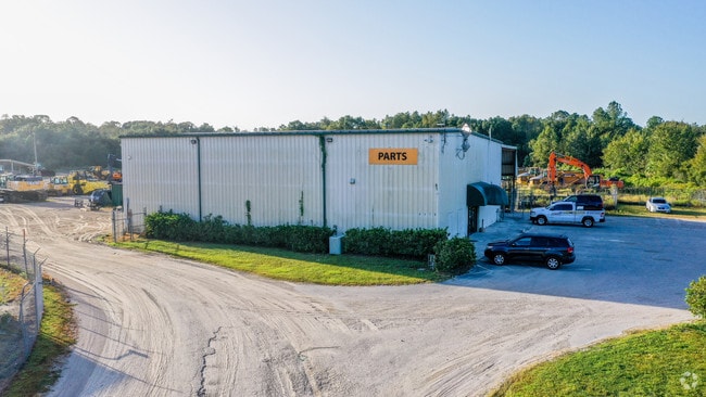
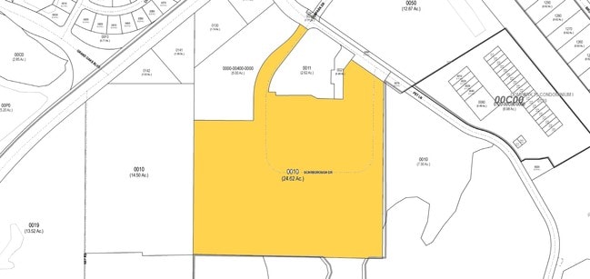
Property Record
4610 Scarborough Dr, Lutz, FL 33559

NEARBY LISTINGS FOR SALE OR LEASE
Property Detail
4610 Scarborough Dr
Tampa-St. Petersburg-Clearwater, FL
Pet Lane Industrial
14-26-19-0000-00300-0010
COM SE COR SEC14THN48DG1957W 4863.51FT TH N50DG3255E100FT TH S39DG2705E290FTTHCVLRAD 250FTCHDBRG&DISTS51DG2246E 103.34FTTHCVRRAD350FTCHDBRG& DISTS19DG3431W100.54FTFORPOB THS55DG3328E58.76FT THCVLRAD 50.83FTCHDBRG&DISTS44DG3808W 12.38FTTHS37DG3833W278
Commercialnec
Pasco
X
Florida
12101C0407F
1
2024
24.69 AC
2026
Pasco County
011006
Tampa/St Petersburg
81,582 SF
DEMOGRAPHICS near 4610 Scarborough Dr
1 Mile
3 Mile
5 Mile
2024 Total Population
6,388
41,757
109,638
2029 Population
7,594
50,281
130,161
Pop Growth 2024-2029
+ 18.88%
+ 20.41%
+ 18.72%
Average Age
38
38
39
2024 Total Households
2,266
14,922
39,034
HH Growth 2024-2029
+ 18.89%
+ 20.35%
+ 18.71%
Median Household Inc
$111,662
$101,337
$101,232
Avg Household Size
2.80
2.80
2.80
2024 Avg HH Vehicles
2.00
2.00
2.00
Median Home Value
$288,783
$325,206
$331,177
Median Year Built
2002
2004
2003
Nearby Places
Map Layers
Map Styles
 Street
 Aerial
- Restaurants
- Banks
- Shops
- Fitness
- Groceries
PUBLIC TRANSPORTATION
AIRPORT
Tampa International
DRIVE
WALK
Distance
Tampa International
41 min
29.7 mi
St Pete-Clearwater International
DRIVE
WALK
Distance
St Pete-Clearwater International
59 min
38.9 mi
Freight Ports
Port of Tampa Bay
DRIVE
WALK
Distance
Port of Tampa Bay
37 min
25.3 mi
Nearby Properties
Address
Land Use
TOTAL SIZE
Lot Size
Zoning
Address
Land Use
TOTAL SIZE
Lot Size
Zoning
455,090 SF
52.24 AC
MPUD
Address
Land Use
TOTAL SIZE
Lot Size
Zoning
603,350 SF
28.81 AC
MPUD
Address
Land Use
TOTAL SIZE
Lot Size
Zoning
380,937 SF
13.58 AC
MPUD
Address
Land Use
TOTAL SIZE
Lot Size
Zoning
306,559 SF
34.59 AC
MPUD
Address
Land Use
TOTAL SIZE
Lot Size
Zoning
293,253 SF
51.11 AC
MPUD
Address
Land Use
TOTAL SIZE
Lot Size
Zoning
343,155 SF
23.92 AC
MPUD
Address
Land Use
TOTAL SIZE
Lot Size
Zoning
38,091 SF
43.42 AC
MPUD
Address
Land Use
TOTAL SIZE
Lot Size
Zoning
425,129 SF
12.72 AC
MPUD
Address
Land Use
TOTAL SIZE
Lot Size
Zoning
347,708 SF
43.40 AC
MPUD
Address
Land Use
TOTAL SIZE
Lot Size
Zoning
346,880 SF
20.01 AC
MPUD
Address
Land Use
TOTAL SIZE
Lot Size
Zoning
324,184 SF
19.12 AC
MPUD
Address
Land Use
TOTAL SIZE
Lot Size
Zoning
263,289 SF
26.30 AC
MPUD
Address
Land Use
TOTAL SIZE
Lot Size
Zoning
315,343 SF
20.80 AC
MPUD
Address
Land Use
TOTAL SIZE
Lot Size
Zoning
267,326 SF
22.50 AC
MPUD
Address
Land Use
TOTAL SIZE
Lot Size
Zoning
279,167 SF
14.75 AC
MPUD
Address
Land Use
TOTAL SIZE
Lot Size
Zoning
275,549 SF
16.24 AC
C2
Address
Land Use
TOTAL SIZE
Lot Size
Zoning
192,698 SF
19.31 AC
MPUD
Address
Land Use
TOTAL SIZE
Lot Size
Zoning
244,355 SF
70.12 AC
MPUD
Address
Land Use
TOTAL SIZE
Lot Size
Zoning
153,412 SF
9.77 AC
MPUD
Address
Land Use
TOTAL SIZE
Lot Size
Zoning
146,401 SF
17.78 AC
MPUD
Address
Land Use
TOTAL SIZE
Lot Size
Zoning
147,238 SF
13.89 AC
MPUD
Address
Land Use
TOTAL SIZE
Lot Size
Zoning
136,319 SF
26.11 AC
MPUD
Address
Land Use
TOTAL SIZE
Lot Size
Zoning
115,596 SF
3.83 AC
C2
Address
Land Use
TOTAL SIZE
Lot Size
Zoning
106,926 SF
89.04 AC
MPUD
Address
Land Use
TOTAL SIZE
Lot Size
Zoning
83,294 SF
7.68 AC
MPUD
Address
Land Use
TOTAL SIZE
Lot Size
Zoning
86,782 SF
12.21 AC
C2
Address
Land Use
TOTAL SIZE
Lot Size
Zoning
97,416 SF
0.94 AC
MPUD
Address
Land Use
TOTAL SIZE
Lot Size
Zoning
28,631 SF
8.84 AC
MPUD
Address
Land Use
TOTAL SIZE
Lot Size
Zoning
91,866 SF
2.70 AC
MPUD
Address
Land Use
TOTAL SIZE
Lot Size
Zoning
96,210 SF
0.85 AC
MPUD
The World's #1 Commercial Real Estate Marketplace
Connect with us
© 2026 CoStar Group
The information above has been obtained from sources believed reliable. While we do not doubt its accuracy we have not verified it and make no guarantee, warranty or representation about it. It is your responsibility to independently confirm its accuracy and completeness. Any projections, opinions, assumptions, or estimates used are for example only and do not represent the current or future performance of the property. The value of this transaction to you depends on tax and other factors which should be evaluated by your tax, financial, and legal advisors. You and your advisors should conduct a careful, independent investigation of the property to determine to your satisfaction the suitability of the property for your needs.