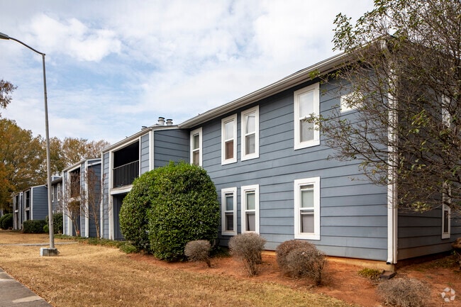
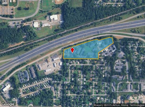
Property Record
4611 Governors House Dr Sw, Huntsville, AL 35805
NEARBY LISTINGS FOR SALE OR LEASE
Property Detail
4611 Governors House Dr Sw
17-02-04-4-002-005.000
Woodall Longview S/D
Autorepair
SEC 4 T4S R1W COM AT THE CEN OF THE E BDRY OF SEC 4 TH S 891.95 FT TH W 1214.39 FT TH S 56 DEG W 86.32 FT TO THE POB TH FR TH
X
Madison
01089C0309E
Alabama
2025
10.80 AC
2025
UA Huntsville
002200
Huntsville
576 SF
Huntsville, AL
DEMOGRAPHICS near 4611 Governors House Dr Sw
1 Mile
3 Mile
5 Mile
2024 Total Population
7,039
54,841
125,565
2029 Population
7,755
61,056
139,610
Pop Growth 2024-2029
+ 10.17%
+ 11.33%
+ 11.19%
Average Age
34
36
39
2024 Total Households
2,323
23,954
56,317
HH Growth 2024-2029
+ 11.45%
+ 11.97%
+ 11.74%
Median Household Inc
$37,738
$37,695
$53,487
Avg Household Size
2.10
2.00
2.10
2024 Avg HH Vehicles
2.00
1.00
2.00
Median Home Value
$94,527
$104,561
$190,884
Median Year Built
1971
1974
1976
Nearby Places
- Restaurants
- Banks
- Shops
- Fitness
- Groceries
PUBLIC TRANSPORTATION
AIRPORT
Huntsville International-Carl T Jones Field
DRIVE
WALK
Distance
Huntsville International-Carl T Jones Field
19 min
11.4 mi
Freight Ports
Port of Mobile
DRIVE
WALK
Distance
Port of Mobile
387 min
352.6 mi
Nearby Properties
Address
Land Use
TOTAL SIZE
Lot Size
Zoning
Address
Land Use
TOTAL SIZE
Lot Size
Zoning
34,373 SF
20.08 AC
Address
Land Use
TOTAL SIZE
Lot Size
Zoning
208,719 SF
26.55 AC
Address
Land Use
TOTAL SIZE
Lot Size
Zoning
15,182 SF
20 AC
Address
Land Use
TOTAL SIZE
Lot Size
Zoning
89,358 SF
Address
Land Use
TOTAL SIZE
Lot Size
Zoning
5,577 SF
12.72 AC
Address
Land Use
TOTAL SIZE
Lot Size
Zoning
76,442 SF
Address
Land Use
TOTAL SIZE
Lot Size
Zoning
79,332 SF
4.03 AC
Address
Land Use
TOTAL SIZE
Lot Size
Zoning
59,317 SF
3.38 AC
Address
Land Use
TOTAL SIZE
Lot Size
Zoning
4,681 SF
8.36 AC
Address
Land Use
TOTAL SIZE
Lot Size
Zoning
31,050 SF
Address
Land Use
TOTAL SIZE
Lot Size
Zoning
56,426 SF
13.78 AC
Address
Land Use
TOTAL SIZE
Lot Size
Zoning
0.77 AC
Address
Land Use
TOTAL SIZE
Lot Size
Zoning
25,619 SF
Address
Land Use
TOTAL SIZE
Lot Size
Zoning
10,399 SF
31.50 AC
Address
Land Use
TOTAL SIZE
Lot Size
Zoning
6,258 SF
14 AC
Address
Land Use
TOTAL SIZE
Lot Size
Zoning
60,647 SF
4.90 AC
Address
Land Use
TOTAL SIZE
Lot Size
Zoning
61,745 SF
7.51 AC
Address
Land Use
TOTAL SIZE
Lot Size
Zoning
18,182 SF
Address
Land Use
TOTAL SIZE
Lot Size
Zoning
76,644 SF
14 AC
Address
Land Use
TOTAL SIZE
Lot Size
Zoning
25,619 SF
Address
Land Use
TOTAL SIZE
Lot Size
Zoning
25,619 SF
Address
Land Use
TOTAL SIZE
Lot Size
Zoning
61,559 SF
5.15 AC
Address
Land Use
TOTAL SIZE
Lot Size
Zoning
47,696 SF
1.63 AC
Address
Land Use
TOTAL SIZE
Lot Size
Zoning
76,079 SF
12.71 AC
Address
Land Use
TOTAL SIZE
Lot Size
Zoning
61,712 SF
0.01 AC
Address
Land Use
TOTAL SIZE
Lot Size
Zoning
41,624 SF
3.80 AC
Address
Land Use
TOTAL SIZE
Lot Size
Zoning
14,630 SF
13.44 AC
Address
Land Use
TOTAL SIZE
Lot Size
Zoning
57,286 SF
7.30 AC
Address
Land Use
TOTAL SIZE
Lot Size
Zoning
64,650 SF
2 AC
Address
Land Use
TOTAL SIZE
Lot Size
Zoning
The World's #1 Commercial Real Estate Marketplace
Connect with us
© 2025 CoStar Group
The information above has been obtained from sources believed reliable. While we do not doubt its accuracy we have not verified it and make no guarantee, warranty or representation about it. It is your responsibility to independently confirm its accuracy and completeness. Any projections, opinions, assumptions, or estimates used are for example only and do not represent the current or future performance of the property. The value of this transaction to you depends on tax and other factors which should be evaluated by your tax, financial, and legal advisors. You and your advisors should conduct a careful, independent investigation of the property to determine to your satisfaction the suitability of the property for your needs.