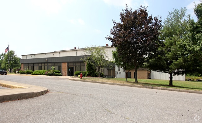
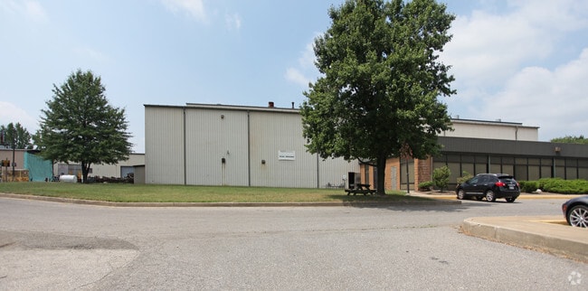
Property Record
4611 N Point Blvd, Sparrows Point, MD 21219

Property Detail
4611 N Point Blvd
15-1800012273
9.913 AC GRAYS YARD AREA
Warehouse
BALTIMORE
MHIM
Maryland
B and X Area of moderate flood hazard, usually the area between the limits of the 100-year and 500-year floods.
3
2024
9.91 AC
2025
Baltimore County East
452400
Baltimore
28,600 SF
Baltimore-Columbia-Towson, MD
NEARBY LISTINGS FOR SALE OR LEASE
DEMOGRAPHICS near 4611 N Point Blvd
1 mile
3 mile
5 mile
2025 Total Population
3,234
48,172
120,443
2030 Population
3,240
48,469
120,845
Pop Growth 2025-2030
+ 0.19%
+ 0.62%
+ 0.33%
Average Age
44
40
40
2025 Total Households
1,270
18,268
46,049
HH Growth 2025-2030
+ 0.16%
+ 0.61%
+ 0.36%
Median Household Inc
$86,375
$69,346
$65,209
Avg Household Size
2.50
2.60
2.50
2025 Avg HH Vehicles
2.00
2.00
2.00
Median Home Value
$338,766
$246,155
$242,530
Median Year Built
1954
1955
1956
Nearby Places
Map Layers
Map Styles
 Street
 Aerial
Layers
 Traffic
 Biking
Places
Listings with unknown addresses are not visible on the map
- Restaurants
- Banks
- Shops
- Fitness
- Groceries
PUBLIC TRANSPORTATION
AIRPORT
Baltimore/Washington International Thurgood Marshall
Drive
Walk
Distance
Baltimore/Washington International Thurgood Marshall
30 min
18.1 mi
Freight Ports
Port of Baltimore
Drive
Walk
Distance
Port of Baltimore
22 min
11.5 mi
Nearby Properties
Address
Land Use
TOTAL SIZE
Lot Size
Zoning
Address
Land Use
TOTAL SIZE
Lot Size
Zoning
1,877,670 SF
90.21 AC
Address
Land Use
TOTAL SIZE
Lot Size
Zoning
Address
Land Use
TOTAL SIZE
Lot Size
Zoning
979,200 SF
49.24 AC
Address
Land Use
TOTAL SIZE
Lot Size
Zoning
859,500 SF
64.32 AC
MH-IM
Address
Land Use
TOTAL SIZE
Lot Size
Zoning
1,500,400 SF
93.63 AC
Address
Land Use
TOTAL SIZE
Lot Size
Zoning
1,282,700 SF
66.23 AC
Address
Land Use
TOTAL SIZE
Lot Size
Zoning
161,190 SF
115.02 AC
Address
Land Use
TOTAL SIZE
Lot Size
Zoning
698,880 SF
60.82 AC
Address
Land Use
TOTAL SIZE
Lot Size
Zoning
519,489 SF
45.05 AC
Address
Land Use
TOTAL SIZE
Lot Size
Zoning
812,250 SF
45.19 AC
Address
Land Use
TOTAL SIZE
Lot Size
Zoning
603,980 SF
30.68 AC
Address
Land Use
TOTAL SIZE
Lot Size
Zoning
291,062 SF
47.39 AC
Address
Land Use
TOTAL SIZE
Lot Size
Zoning
Address
Land Use
TOTAL SIZE
Lot Size
Zoning
735,681 SF
44.98 AC
Address
Land Use
TOTAL SIZE
Lot Size
Zoning
449,920 SF
26.42 AC
Address
Land Use
TOTAL SIZE
Lot Size
Zoning
401,280 SF
25.38 AC
Address
Land Use
TOTAL SIZE
Lot Size
Zoning
33.65 AC
DR16
Address
Land Use
TOTAL SIZE
Lot Size
Zoning
72,600 SF
35.27 AC
Address
Land Use
TOTAL SIZE
Lot Size
Zoning
399,600 SF
21.59 AC
Address
Land Use
TOTAL SIZE
Lot Size
Zoning
213,997 SF
45.22 AC
DR
Address
Land Use
TOTAL SIZE
Lot Size
Zoning
75.99 AC
Address
Land Use
TOTAL SIZE
Lot Size
Zoning
13.72 AC
DR16
Address
Land Use
TOTAL SIZE
Lot Size
Zoning
12.11 AC
DR16
Address
Land Use
TOTAL SIZE
Lot Size
Zoning
24,300 SF
1.62 AC
MHIM
Address
Land Use
TOTAL SIZE
Lot Size
Zoning
197,823 SF
34.32 AC
DR5.5
Address
Land Use
TOTAL SIZE
Lot Size
Zoning
189,347 SF
28.24 AC
DR10
Address
Land Use
TOTAL SIZE
Lot Size
Zoning
10.27 AC
DR16
Address
Land Use
TOTAL SIZE
Lot Size
Zoning
463,050 SF
24.27 AC
ML
Address
Land Use
TOTAL SIZE
Lot Size
Zoning
119,700 SF
6.97 AC
Address
Land Use
TOTAL SIZE
Lot Size
Zoning
204,000 SF
15.36 AC
The World's #1 Commercial Real Estate Marketplace
Connect with us
© 2026 CoStar Group
The information above has been obtained from sources believed reliable. While we do not doubt its accuracy we have not verified it and make no guarantee, warranty or representation about it. It is your responsibility to independently confirm its accuracy and completeness. Any projections, opinions, assumptions, or estimates used are for example only and do not represent the current or future performance of the property. The value of this transaction to you depends on tax and other factors which should be evaluated by your tax, financial, and legal advisors. You and your advisors should conduct a careful, independent investigation of the property to determine to your satisfaction the suitability of the property for your needs.