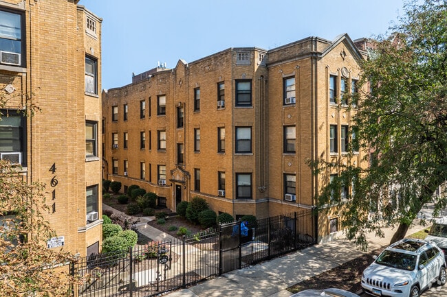
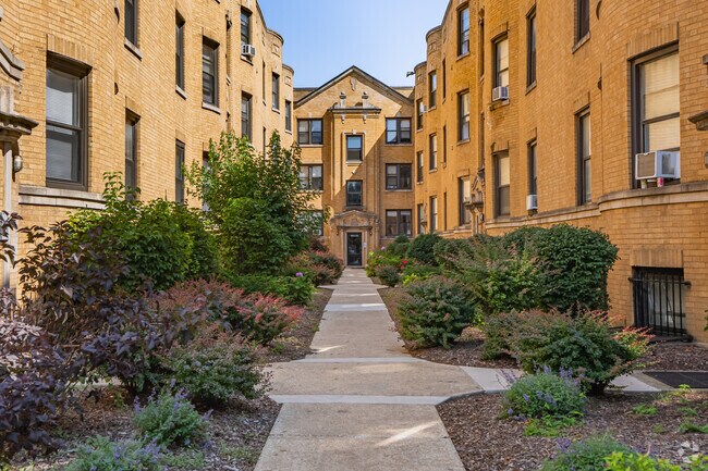
Property Record
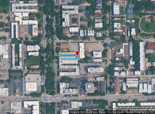
4615 S Drexel Blvd, Chicago, IL 60653
NEARBY LISTINGS FOR SALE OR LEASE
-
-
-
-
-
-
-
-
-
No Photo
-
-
-
-
-
-
-
-
-
-
-
-
-
-
-
-
-
-
-
-
-
-
View all Chicago listings for sale on LoopNet.com
Property Detail
4615 S Drexel Blvd
Chicago-Naperville-Elgin, IL-IN-WI
Walker & Stinsons
20-02-316-003-0000
(WALKER) & (STINSONS) SUB OF WH SW SEC 02-38-14
Apartment
Cook
X
Illinois
17031C0536K
2,3
2023
0.43 AC
2024
Kenwood
390300
Chicago
28,626 SF
DEMOGRAPHICS near 4615 S Drexel Blvd
1 Mile
3 Mile
5 Mile
2024 Total Population
49,281
194,595
553,715
2029 Population
48,217
188,421
531,508
Pop Growth 2024-2029
(2.16%)
(3.17%)
(4.01%)
Average Age
39
38
38
2024 Total Households
23,932
87,224
234,852
HH Growth 2024-2029
(2.51%)
(3.34%)
(3.93%)
Median Household Inc
$45,920
$40,785
$46,091
Avg Household Size
2.00
2.10
2.20
2024 Avg HH Vehicles
1.00
1.00
1.00
Median Home Value
$360,528
$314,899
$269,998
Median Year Built
1962
1956
1951
Nearby Places
Map Layers
Map Styles
 Street
 Aerial
- Restaurants
- Banks
- Shops
- Fitness
- Groceries
PUBLIC TRANSPORTATION
TRANSIT/SUBWAY
47Th Street Station (Green Line) (Green Line - Chicago Transit Authority "L" Trains (The "L"))
DRIVE
WALK
Distance
47Th Street Station (Green Line) (Green Line - Chicago Transit Authority "L" Trains (The "L"))
3 min
19 min
1.0 mi
COMMUTER RAIL
47Th Street Station (Metra Electric Line - Northeast Illinois Regional Commuter Railroad (Metra))
DRIVE
WALK
Distance
47Th Street Station (Metra Electric Line - Northeast Illinois Regional Commuter Railroad (Metra))
2 min
15 min
0.8 mi
53Rd Street Hyde Park Station (Metra Electric Line - Northeast Illinois Regional Commuter Railroad (Metra))
DRIVE
WALK
Distance
53Rd Street Hyde Park Station (Metra Electric Line - Northeast Illinois Regional Commuter Railroad (Metra))
4 min
1.5 mi
AIRPORT
Chicago Midway International
DRIVE
WALK
Distance
Chicago Midway International
17 min
8.7 mi
Chicago O'Hare International
DRIVE
WALK
Distance
Chicago O'Hare International
38 min
23.5 mi
Freight Ports
Port Milwaukee
DRIVE
WALK
Distance
Port Milwaukee
116 min
91.7 mi
SALE & LEASE HISTORY
LISTING DATE
SALE/LEASE

Jul 10, 2020
For Sale
Nearby Properties
Address
Land Use
TOTAL SIZE
Lot Size
Zoning
Address
Land Use
TOTAL SIZE
Lot Size
Zoning
590,844 SF
0.80 AC
PD 26
Address
Land Use
TOTAL SIZE
Lot Size
Zoning
1,302,463 SF
3.14 AC
PD 1211
Address
Land Use
TOTAL SIZE
Lot Size
Zoning
3.14 AC
PD 1211
Address
Land Use
TOTAL SIZE
Lot Size
Zoning
250,040 SF
15.70 AC
PD 1169
Address
Land Use
TOTAL SIZE
Lot Size
Zoning
136,720 SF
0.54 AC
PD 1
Address
Land Use
TOTAL SIZE
Lot Size
Zoning
2.65 AC
PD 38
Address
Land Use
TOTAL SIZE
Lot Size
Zoning
10 AC
PD 1169
Address
Land Use
TOTAL SIZE
Lot Size
Zoning
8.54 AC
PD 1169
Address
Land Use
TOTAL SIZE
Lot Size
Zoning
1,687,020 SF
10.25 AC
PD 1169
Address
Land Use
TOTAL SIZE
Lot Size
Zoning
304,685 SF
1.11 AC
PD 1218
Address
Land Use
TOTAL SIZE
Lot Size
Zoning
7,200 SF
0.22 AC
B3-3
Address
Land Use
TOTAL SIZE
Lot Size
Zoning
38,214 SF
0.92 AC
C2-3
Address
Land Use
TOTAL SIZE
Lot Size
Zoning
156,800 SF
2.65 AC
PD 38
Address
Land Use
TOTAL SIZE
Lot Size
Zoning
1.09 AC
B2-2
Address
Land Use
TOTAL SIZE
Lot Size
Zoning
PD 43
Address
Land Use
TOTAL SIZE
Lot Size
Zoning
451,349 SF
1.62 AC
PD 1062
Address
Land Use
TOTAL SIZE
Lot Size
Zoning
794,288 SF
6.53 AC
PD 41
Address
Land Use
TOTAL SIZE
Lot Size
Zoning
283,180 SF
1.41 AC
M2-3
Address
Land Use
TOTAL SIZE
Lot Size
Zoning
0.73 AC
PD 1072
Address
Land Use
TOTAL SIZE
Lot Size
Zoning
1.65 AC
B2-3
Address
Land Use
TOTAL SIZE
Lot Size
Zoning
PD 43
Address
Land Use
TOTAL SIZE
Lot Size
Zoning
769,600 SF
PD 282
Address
Land Use
TOTAL SIZE
Lot Size
Zoning
88,000 SF
1.39 AC
RM-5,B1-3
Address
Land Use
TOTAL SIZE
Lot Size
Zoning
3.23 AC
PD 1509
Address
Land Use
TOTAL SIZE
Lot Size
Zoning
78,000 SF
0.62 AC
RM-5
Address
Land Use
TOTAL SIZE
Lot Size
Zoning
0.27 AC
PD 1
Address
Land Use
TOTAL SIZE
Lot Size
Zoning
7.47 AC
RT-4
Address
Land Use
TOTAL SIZE
Lot Size
Zoning
4.04 AC
PD 1509
Address
Land Use
TOTAL SIZE
Lot Size
Zoning
3.69 AC
PD 1509
Address
Land Use
TOTAL SIZE
Lot Size
Zoning
130,560 SF
0.55 AC
PD 18
The World's #1 Commercial Real Estate Marketplace
Connect with us
© 2025 CoStar Group
The information above has been obtained from sources believed reliable. While we do not doubt its accuracy we have not verified it and make no guarantee, warranty or representation about it. It is your responsibility to independently confirm its accuracy and completeness. Any projections, opinions, assumptions, or estimates used are for example only and do not represent the current or future performance of the property. The value of this transaction to you depends on tax and other factors which should be evaluated by your tax, financial, and legal advisors. You and your advisors should conduct a careful, independent investigation of the property to determine to your satisfaction the suitability of the property for your needs.