Property Record
4612 Centurion Dr, Bismarck, ND 58504
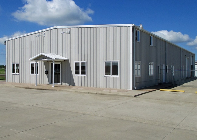


Property Detail
4612 Centurion Dr
Bismarck, ND
TWN: 138 RNG: 80 SUB: 381388064 BLK: 05 METRO IND PK REPLAT BLOCK 05 LOT 3 525545
38-138-80-64-05-030
BURLEIGH
Publicstorage
North Dakota
B and X Area of moderate flood hazard, usually the area between the limits of the 100-year and 500-year floods.
3-52554
2025
1 AC
2025
South Bismarck
011200
Other Market Areas
8,400 SF
NEARBY LISTINGS FOR SALE OR LEASE
-
-
View all Bismarck listings for sale on LoopNet.com
DEMOGRAPHICS near 4612 Centurion Dr
1 mile
3 mile
5 mile
2025 Total Population
829
16,816
51,218
2030 Population
866
17,369
52,931
Pop Growth 2025-2030
+ 4.46%
+ 3.29%
+ 3.34%
Average Age
35
37
39
2025 Total Households
192
6,222
21,014
HH Growth 2025-2030
+ 3.65%
+ 3.57%
+ 3.66%
Median Household Inc
$120,454
$93,986
$76,107
Avg Household Size
2.50
2.40
2.20
2025 Avg HH Vehicles
2.00
2.00
2.00
Median Home Value
$341,935
$279,016
$270,988
Median Year Built
1995
1995
1978
Nearby Places
Map Layers
Map Styles
 Street
 Aerial
Layers
 Traffic
 Biking
Places
Listings with unknown addresses are not visible on the map
- Restaurants
- Banks
- Shops
- Fitness
- Groceries
SALE & LEASE HISTORY
LISTING DATE
SALE/LEASE

May 22, 2018
For Lease
Jul 19, 2018
For Sale
Apr 30, 2019
For Sale
Nearby Properties
Address
Land Use
TOTAL SIZE
Lot Size
Zoning
Address
Land Use
TOTAL SIZE
Lot Size
Zoning
26.42 AC
MA
Address
Land Use
TOTAL SIZE
Lot Size
Zoning
35.42 AC
MA
Address
Land Use
TOTAL SIZE
Lot Size
Zoning
60,105 SF
11.86 AC
RM30
Address
Land Use
TOTAL SIZE
Lot Size
Zoning
6.29 AC
RM30
Address
Land Use
TOTAL SIZE
Lot Size
Zoning
20.41 AC
MA
Address
Land Use
TOTAL SIZE
Lot Size
Zoning
44,652 SF
13.84 AC
RM30
Address
Land Use
TOTAL SIZE
Lot Size
Zoning
14.22 AC
MA
Address
Land Use
TOTAL SIZE
Lot Size
Zoning
81.73 AC
RMH
Address
Land Use
TOTAL SIZE
Lot Size
Zoning
42,908 SF
12.44 AC
MA
Address
Land Use
TOTAL SIZE
Lot Size
Zoning
42,908 SF
12.14 AC
MA
Address
Land Use
TOTAL SIZE
Lot Size
Zoning
64,008 SF
12.61 AC
MA
Address
Land Use
TOTAL SIZE
Lot Size
Zoning
34.07 AC
RMH
Address
Land Use
TOTAL SIZE
Lot Size
Zoning
92,982 SF
3.80 AC
RM30
Address
Land Use
TOTAL SIZE
Lot Size
Zoning
56,846 SF
8.26 AC
MA
Address
Land Use
TOTAL SIZE
Lot Size
Zoning
4,084 SF
2.85 AC
RM10
Address
Land Use
TOTAL SIZE
Lot Size
Zoning
4.55 AC
RM20
Address
Land Use
TOTAL SIZE
Lot Size
Zoning
1,569 SF
28.70 AC
RMH
Address
Land Use
TOTAL SIZE
Lot Size
Zoning
87,783 SF
3.86 AC
RM30
Address
Land Use
TOTAL SIZE
Lot Size
Zoning
87,783 SF
4.08 AC
RM30
Address
Land Use
TOTAL SIZE
Lot Size
Zoning
87,783 SF
3.76 AC
RM30
Address
Land Use
TOTAL SIZE
Lot Size
Zoning
72,975 SF
5.97 AC
MA
Address
Land Use
TOTAL SIZE
Lot Size
Zoning
40,899 SF
2.12 AC
P
Address
Land Use
TOTAL SIZE
Lot Size
Zoning
23,637 SF
4.76 AC
MA
Address
Land Use
TOTAL SIZE
Lot Size
Zoning
45,507 SF
2.76 AC
Address
Land Use
TOTAL SIZE
Lot Size
Zoning
30,170 SF
22.94 AC
MA
Address
Land Use
TOTAL SIZE
Lot Size
Zoning
34,220 SF
3.52 AC
MA
Address
Land Use
TOTAL SIZE
Lot Size
Zoning
26,040 SF
3.41 AC
MA
Address
Land Use
TOTAL SIZE
Lot Size
Zoning
26,040 SF
2.30 AC
MA
Address
Land Use
TOTAL SIZE
Lot Size
Zoning
10,726 SF
2.41 AC
MA
Address
Land Use
TOTAL SIZE
Lot Size
Zoning
45,507 SF
2.25 AC
The World's #1 Commercial Real Estate Marketplace
Connect with us
© 2026 CoStar Group
The information above has been obtained from sources believed reliable. While we do not doubt its accuracy we have not verified it and make no guarantee, warranty or representation about it. It is your responsibility to independently confirm its accuracy and completeness. Any projections, opinions, assumptions, or estimates used are for example only and do not represent the current or future performance of the property. The value of this transaction to you depends on tax and other factors which should be evaluated by your tax, financial, and legal advisors. You and your advisors should conduct a careful, independent investigation of the property to determine to your satisfaction the suitability of the property for your needs.