Property Record
4612 E 106Th St N, Sperry, OK 74073
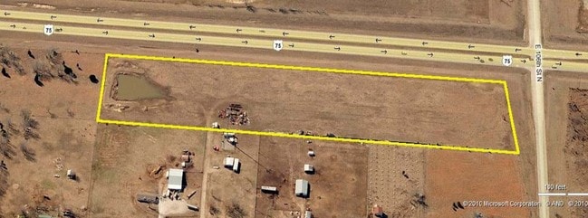

Property Detail
4612 E 106Th St N
Tulsa, OK
LT 1 LESS BEG NEC LT 1 TH S100 SW33 N100 NE33 POB BLK 1
56580-13-16-00015
TULSA
Commercialacreage
Oklahoma
CS
1
B and X Area of moderate flood hazard, usually the area between the limits of the 100-year and 500-year floods.
12.53 AC
2025
Northeast
2025
Tulsa
005808
NEARBY LISTINGS FOR SALE OR LEASE
DEMOGRAPHICS near 4612 E 106Th St N
1 mile
3 mile
5 mile
2025 Total Population
608
5,422
33,359
2030 Population
632
5,711
34,720
Pop Growth 2025-2030
+ 3.95%
+ 5.33%
+ 4.08%
Average Age
40
40
38
2025 Total Households
220
1,941
12,377
HH Growth 2025-2030
+ 4.09%
+ 5.41%
+ 4.10%
Median Household Inc
$70,446
$101,778
$83,191
Avg Household Size
2.80
2.80
2.70
2025 Avg HH Vehicles
3.00
3.00
2.00
Median Home Value
$348,437
$383,231
$265,845
Median Year Built
1991
2005
1998
Nearby Places
Map Layers
Map Styles
 Street
 Aerial
Layers
 Traffic
 Biking
Places
Listings with unknown addresses are not visible on the map
- Restaurants
- Banks
- Shops
- Fitness
- Groceries
PUBLIC TRANSPORTATION
AIRPORT
Tulsa International
Drive
Walk
Distance
Tulsa International
17 min
11.6 mi
Freight Ports
Tulsa Port Of Catoosa
Drive
Walk
Distance
Tulsa Port Of Catoosa
24 min
16.5 mi
Nearby Properties
Address
Land Use
TOTAL SIZE
Lot Size
Zoning
Address
Land Use
TOTAL SIZE
Lot Size
Zoning
457,823 SF
25.72 AC
IM
Address
Land Use
TOTAL SIZE
Lot Size
Zoning
27,314 SF
12.29 AC
AG
Address
Land Use
TOTAL SIZE
Lot Size
Zoning
229,485 SF
16.77 AC
IM
Address
Land Use
TOTAL SIZE
Lot Size
Zoning
32,300 SF
20.88 AC
NCU
Address
Land Use
TOTAL SIZE
Lot Size
Zoning
113.74 AC
AG
Address
Land Use
TOTAL SIZE
Lot Size
Zoning
14,836 SF
9.39 AC
AGR
Address
Land Use
TOTAL SIZE
Lot Size
Zoning
6,280 SF
15.43 AC
AG
Address
Land Use
TOTAL SIZE
Lot Size
Zoning
58,956 SF
8.70 AC
RE
Address
Land Use
TOTAL SIZE
Lot Size
Zoning
10,812 SF
8.56 AC
AG
Address
Land Use
TOTAL SIZE
Lot Size
Zoning
64,400 SF
7.18 AC
IL
Address
Land Use
TOTAL SIZE
Lot Size
Zoning
15.89 AC
AG
Address
Land Use
TOTAL SIZE
Lot Size
Zoning
13,270 SF
8.54 AC
AG
Address
Land Use
TOTAL SIZE
Lot Size
Zoning
10,540 SF
1.60 AC
CS
Address
Land Use
TOTAL SIZE
Lot Size
Zoning
55,300 SF
3.25 AC
CS
Address
Land Use
TOTAL SIZE
Lot Size
Zoning
8.89 AC
IL
Address
Land Use
TOTAL SIZE
Lot Size
Zoning
2,437 SF
4.88 AC
AG
Address
Land Use
TOTAL SIZE
Lot Size
Zoning
5.22 AC
AG
Address
Land Use
TOTAL SIZE
Lot Size
Zoning
6.25 AC
AG
Address
Land Use
TOTAL SIZE
Lot Size
Zoning
40 AC
AG
Address
Land Use
TOTAL SIZE
Lot Size
Zoning
14,100 SF
2.13 AC
CS
Address
Land Use
TOTAL SIZE
Lot Size
Zoning
8,311 SF
2.86 AC
AG
Address
Land Use
TOTAL SIZE
Lot Size
Zoning
7,156 SF
115.11 AC
AG
Address
Land Use
TOTAL SIZE
Lot Size
Zoning
8,000 SF
3.71 AC
CS
Address
Land Use
TOTAL SIZE
Lot Size
Zoning
8,788 SF
2.27 AC
AG
Address
Land Use
TOTAL SIZE
Lot Size
Zoning
4,160 SF
4.62 AC
Address
Land Use
TOTAL SIZE
Lot Size
Zoning
6,000 SF
2.51 AC
AG
Address
Land Use
TOTAL SIZE
Lot Size
Zoning
8,672 SF
2.50 AC
AG
Address
Land Use
TOTAL SIZE
Lot Size
Zoning
9.62 AC
AG
Address
Land Use
TOTAL SIZE
Lot Size
Zoning
3.38 AC
CS
Address
Land Use
TOTAL SIZE
Lot Size
Zoning
5,816 SF
2.51 AC
AG
The World's #1 Commercial Real Estate Marketplace
Connect with us
© 2026 CoStar Group
The information above has been obtained from sources believed reliable. While we do not doubt its accuracy we have not verified it and make no guarantee, warranty or representation about it. It is your responsibility to independently confirm its accuracy and completeness. Any projections, opinions, assumptions, or estimates used are for example only and do not represent the current or future performance of the property. The value of this transaction to you depends on tax and other factors which should be evaluated by your tax, financial, and legal advisors. You and your advisors should conduct a careful, independent investigation of the property to determine to your satisfaction the suitability of the property for your needs.