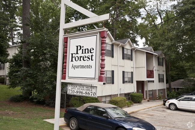
Property Record
4612 Poplar Rd, Pine Lake, GA 30072

NEARBY LISTINGS FOR SALE OR LEASE
-
-
No Photo
-
View all Pine Lake listings for sale on LoopNet.com
Property Detail
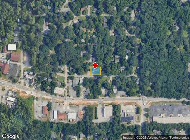
4612 Poplar Rd
Atlanta-Sandy Springs-Roswell, GA
Pine Lake
18-041-08-207
100 X 87 X 100 X 87 . . . . . . . . . 0.20AC 1-17-96
Apartment
DeKalb
X
Georgia
13089C0087J
748
2025
0.20 AC
2025
Stone Mountain
023219
Atlanta
3,558 SF
DEMOGRAPHICS near 4612 Poplar Rd
1 Mile
3 Mile
5 Mile
2024 Total Population
11,051
116,696
235,251
2029 Population
10,786
116,445
234,833
Pop Growth 2024-2029
(2.40%)
(0.22%)
(0.18%)
Average Age
37
37
39
2024 Total Households
3,969
42,177
89,922
HH Growth 2024-2029
(2.60%)
(0.09%)
(0.05%)
Median Household Inc
$54,615
$47,551
$60,807
Avg Household Size
2.70
2.60
2.50
2024 Avg HH Vehicles
2.00
2.00
2.00
Median Home Value
$212,062
$200,667
$244,996
Median Year Built
1977
1978
1978
Nearby Places
Map Layers
Map Styles
 Street
 Aerial
- Restaurants
- Banks
- Shops
- Fitness
- Groceries
PUBLIC TRANSPORTATION
AIRPORT
Hartsfield - Jackson Atlanta International
DRIVE
WALK
Distance
Hartsfield - Jackson Atlanta International
31 min
20.7 mi
Freight Ports
Georgia Ports - Savannah
DRIVE
WALK
Distance
Georgia Ports - Savannah
284 min
252.6 mi
Nearby Properties
Address
Land Use
TOTAL SIZE
Lot Size
Zoning
Address
Land Use
TOTAL SIZE
Lot Size
Zoning
78,008 SF
11.16 AC
HR-3
Address
Land Use
TOTAL SIZE
Lot Size
Zoning
988,394 SF
102.84 AC
RM100
Address
Land Use
TOTAL SIZE
Lot Size
Zoning
656,837 SF
88.74 AC
RM100
Address
Land Use
TOTAL SIZE
Lot Size
Zoning
287,674 SF
17.63 AC
R75: SF RE
Address
Land Use
TOTAL SIZE
Lot Size
Zoning
350,556 SF
46.09 AC
X
Address
Land Use
TOTAL SIZE
Lot Size
Zoning
455,599 SF
43.15 AC
HR-3
Address
Land Use
TOTAL SIZE
Lot Size
Zoning
587,493 SF
29.79 AC
X
Address
Land Use
TOTAL SIZE
Lot Size
Zoning
295,718 SF
25.64 AC
RM85
Address
Land Use
TOTAL SIZE
Lot Size
Zoning
76,500 SF
2.84 AC
X
Address
Land Use
TOTAL SIZE
Lot Size
Zoning
337,746 SF
29.94 AC
RM100
Address
Land Use
TOTAL SIZE
Lot Size
Zoning
339,262 SF
26.16 AC
RM100
Address
Land Use
TOTAL SIZE
Lot Size
Zoning
319,984 SF
24.70 AC
RM100
Address
Land Use
TOTAL SIZE
Lot Size
Zoning
224,812 SF
19.29 AC
RM75
Address
Land Use
TOTAL SIZE
Lot Size
Zoning
251,327 SF
19.92 AC
X
Address
Land Use
TOTAL SIZE
Lot Size
Zoning
269,639 SF
24.65 AC
RM100
Address
Land Use
TOTAL SIZE
Lot Size
Zoning
396,905 SF
20.82 AC
RM85
Address
Land Use
TOTAL SIZE
Lot Size
Zoning
358,818 SF
22.41 AC
RM100
Address
Land Use
TOTAL SIZE
Lot Size
Zoning
446,287 SF
31 AC
RM100
Address
Land Use
TOTAL SIZE
Lot Size
Zoning
299,798 SF
17.20 AC
X
Address
Land Use
TOTAL SIZE
Lot Size
Zoning
249,184 SF
20 AC
RM100
Address
Land Use
TOTAL SIZE
Lot Size
Zoning
240,276 SF
19.53 AC
RM85
Address
Land Use
TOTAL SIZE
Lot Size
Zoning
302,988 SF
41.36 AC
X
Address
Land Use
TOTAL SIZE
Lot Size
Zoning
180,410 SF
14.50 AC
RM85
Address
Land Use
TOTAL SIZE
Lot Size
Zoning
373,062 SF
20.59 AC
RM100
Address
Land Use
TOTAL SIZE
Lot Size
Zoning
324,116 SF
19.90 AC
A
Address
Land Use
TOTAL SIZE
Lot Size
Zoning
312,258 SF
24.80 AC
X
Address
Land Use
TOTAL SIZE
Lot Size
Zoning
384,545 SF
35.93 AC
RM100
Address
Land Use
TOTAL SIZE
Lot Size
Zoning
273,192 SF
24.07 AC
RM100
Address
Land Use
TOTAL SIZE
Lot Size
Zoning
189,486 SF
18.57 AC
X
Address
Land Use
TOTAL SIZE
Lot Size
Zoning
490,343 SF
28.70 AC
X
The World's #1 Commercial Real Estate Marketplace
Connect with us
© 2025 CoStar Group
The information above has been obtained from sources believed reliable. While we do not doubt its accuracy we have not verified it and make no guarantee, warranty or representation about it. It is your responsibility to independently confirm its accuracy and completeness. Any projections, opinions, assumptions, or estimates used are for example only and do not represent the current or future performance of the property. The value of this transaction to you depends on tax and other factors which should be evaluated by your tax, financial, and legal advisors. You and your advisors should conduct a careful, independent investigation of the property to determine to your satisfaction the suitability of the property for your needs.