Property Record
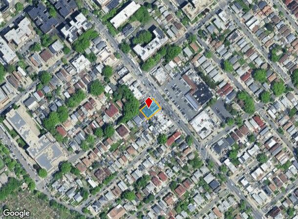
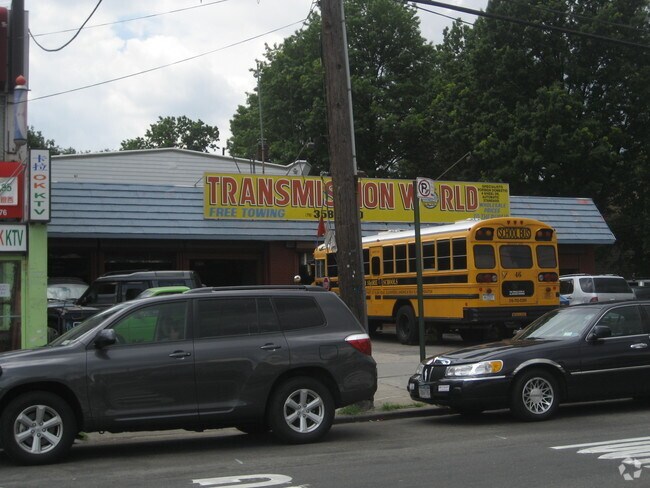
4614 Kissena Blvd, Flushing, NY 11355


NEARBY LISTINGS FOR SALE OR LEASE
Property Detail
4614 Kissena Blvd
05149-0034
Property/Flushing
Autorepair
Queens
X
New York
3604970114F
34
2024
0.17 AC
2025
Northeast Queens
084500
Long Island (New York)
3,750 SF
New York-Jersey City-White Plains, NY-NJ
DEMOGRAPHICS near 4614 Kissena Blvd
1 Mile
3 Mile
5 Mile
2024 Total Population
119,483
708,824
1,556,900
2029 Population
112,973
666,302
1,451,192
Pop Growth 2024-2029
(5.45%)
(6.00%)
(6.79%)
Average Age
44
42
42
2024 Total Households
41,437
248,920
531,954
HH Growth 2024-2029
(5.67%)
(6.04%)
(6.95%)
Median Household Inc
$46,467
$69,466
$71,590
Avg Household Size
2.80
2.70
2.80
2024 Avg HH Vehicles
1.00
1.00
1.00
Median Home Value
$675,517
$688,847
$683,680
Median Year Built
1959
1955
1953
Nearby Places
- Restaurants
- Banks
- Shops
- Fitness
- Groceries
PUBLIC TRANSPORTATION
TRANSIT/SUBWAY
Flushing-Main Street (7 - New York MTA Subway (The Subway))
DRIVE
WALK
Distance
Flushing-Main Street (7 - New York MTA Subway (The Subway))
5 min
17 min
0.9 mi
Flushing-Main Street Station (Port Washington Branch - Long Island Rail Road)
DRIVE
WALK
Distance
Flushing-Main Street Station (Port Washington Branch - Long Island Rail Road)
3 min
18 min
0.9 mi
COMMUTER RAIL
Flushing-Main Street Station (Port Washington Branch - Long Island Rail Road)
DRIVE
WALK
Distance
Flushing-Main Street Station (Port Washington Branch - Long Island Rail Road)
3 min
18 min
0.9 mi
Murray Hill Station (Port Washington Branch - Long Island Rail Road)
DRIVE
WALK
Distance
Murray Hill Station (Port Washington Branch - Long Island Rail Road)
5 min
1.4 mi
AIRPORT
LaGuardia
DRIVE
WALK
Distance
LaGuardia
12 min
4.5 mi
John F Kennedy International
DRIVE
WALK
Distance
John F Kennedy International
18 min
9.6 mi
Newark Liberty International
DRIVE
WALK
Distance
Newark Liberty International
40 min
24.7 mi
Freight Ports
NY - Red Hook Container Terminal
DRIVE
WALK
Distance
NY - Red Hook Container Terminal
24 min
13.4 mi
Nearby Properties
Address
Land Use
TOTAL SIZE
Lot Size
Zoning
Address
Land Use
TOTAL SIZE
Lot Size
Zoning
4,528,000 SF
94.27 AC
R4
Address
Land Use
TOTAL SIZE
Lot Size
Zoning
2,078,606 SF
58.93 AC
R4
Address
Land Use
TOTAL SIZE
Lot Size
Zoning
1,258,350 SF
410.24 AC
PARK
Address
Land Use
TOTAL SIZE
Lot Size
Zoning
1,069,367 SF
14.65 AC
R4
Address
Land Use
TOTAL SIZE
Lot Size
Zoning
772,163 SF
5.24 AC
C4-5X
Address
Land Use
TOTAL SIZE
Lot Size
Zoning
1,292,074 SF
C4-2F
Address
Land Use
TOTAL SIZE
Lot Size
Zoning
234,891 SF
3.17 AC
C4-5X
Address
Land Use
TOTAL SIZE
Lot Size
Zoning
1,516,458 SF
5.97 AC
R7-1
Address
Land Use
TOTAL SIZE
Lot Size
Zoning
15,000 SF
255.27 AC
PARK
Address
Land Use
TOTAL SIZE
Lot Size
Zoning
4,050 SF
113.40 AC
PARK
Address
Land Use
TOTAL SIZE
Lot Size
Zoning
947 SF
101.82 AC
PARK
Address
Land Use
TOTAL SIZE
Lot Size
Zoning
4,800 SF
80.10 AC
PARK
Address
Land Use
TOTAL SIZE
Lot Size
Zoning
332,266 SF
12.57 AC
M2-1
Address
Land Use
TOTAL SIZE
Lot Size
Zoning
1,186,778 SF
31.45 AC
R4
Address
Land Use
TOTAL SIZE
Lot Size
Zoning
344,116 SF
0.92 AC
R7-1
Address
Land Use
TOTAL SIZE
Lot Size
Zoning
577,654 SF
5.38 AC
R6
Address
Land Use
TOTAL SIZE
Lot Size
Zoning
521,944 SF
16.68 AC
R4
Address
Land Use
TOTAL SIZE
Lot Size
Zoning
360,000 SF
5.88 AC
C4-2
Address
Land Use
TOTAL SIZE
Lot Size
Zoning
234,452 SF
2.99 AC
R4
Address
Land Use
TOTAL SIZE
Lot Size
Zoning
377,896 SF
11.36 AC
R3-2
Address
Land Use
TOTAL SIZE
Lot Size
Zoning
384,249 SF
5.56 AC
R5
Address
Land Use
TOTAL SIZE
Lot Size
Zoning
364,424 SF
C5-3
Address
Land Use
TOTAL SIZE
Lot Size
Zoning
250,577 SF
23.17 AC
M2-1
Address
Land Use
TOTAL SIZE
Lot Size
Zoning
281,416 SF
2.57 AC
C4-2
Address
Land Use
TOTAL SIZE
Lot Size
Zoning
382,302 SF
6.23 AC
R2A
Address
Land Use
TOTAL SIZE
Lot Size
Zoning
614,916 SF
28.10 AC
R4
Address
Land Use
TOTAL SIZE
Lot Size
Zoning
2,828 SF
78.05 AC
PARK
Address
Land Use
TOTAL SIZE
Lot Size
Zoning
192,200 SF
9.70 AC
R4
Address
Land Use
TOTAL SIZE
Lot Size
Zoning
454,631 SF
24.61 AC
M1-1
Address
Land Use
TOTAL SIZE
Lot Size
Zoning
4,279,575 SF
144.16 AC
PARK
The World's #1 Commercial Real Estate Marketplace
Connect with us
© 2025 CoStar Group
The information above has been obtained from sources believed reliable. While we do not doubt its accuracy we have not verified it and make no guarantee, warranty or representation about it. It is your responsibility to independently confirm its accuracy and completeness. Any projections, opinions, assumptions, or estimates used are for example only and do not represent the current or future performance of the property. The value of this transaction to you depends on tax and other factors which should be evaluated by your tax, financial, and legal advisors. You and your advisors should conduct a careful, independent investigation of the property to determine to your satisfaction the suitability of the property for your needs.