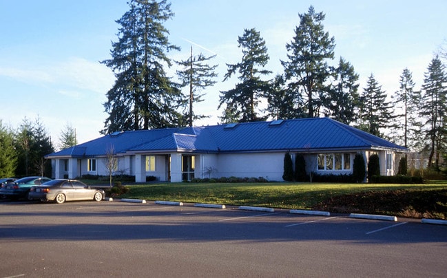
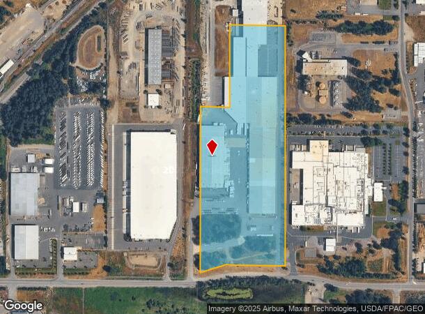
Property Record
4615 192Nd St E, Tacoma, WA 98446
NEARBY LISTINGS FOR SALE OR LEASE
Property Detail
4615 192Nd St E
031936-4038
SECTION 36 TOWNSHIP 19 RANGE 03 QUARTER 43 COM AT SW COR OF SE TH S 89 DEG 46 MIN 04 SEC E ALG S LI OF SD SE 28.06 FT TO A PT LY ON A LI PAR/W & 758.04 FT ELY OF WLY R/W OF NISQUALLY TRANS LI AS APPROPRIATED BY CY OF TAC UND SUP CT CS #91553 SD R/W B
Lumberyard
Pierce
A
Washington
53053C0600E
i
2024
24.33 AC
2025
Parkland/Spanaway
071413
Seattle/Puget Sound
492,365 SF
Seattle-Tacoma-Bellevue, WA
DEMOGRAPHICS near 4615 192Nd St E
1 Mile
3 Mile
5 Mile
2024 Total Population
4,301
73,176
156,689
2029 Population
4,402
74,698
160,442
Pop Growth 2024-2029
+ 2.35%
+ 2.08%
+ 2.40%
Average Age
34
36
37
2024 Total Households
1,383
23,349
51,967
HH Growth 2024-2029
+ 2.31%
+ 2.08%
+ 2.42%
Median Household Inc
$116,666
$96,087
$95,590
Avg Household Size
3.00
3.00
2.90
2024 Avg HH Vehicles
3.00
2.00
2.00
Median Home Value
$424,700
$406,466
$419,940
Median Year Built
2005
1996
1995
Nearby Places
Map Layers
Map Styles
 Street
 Aerial
- Restaurants
- Banks
- Shops
- Fitness
- Groceries
PUBLIC TRANSPORTATION
AIRPORT
Seattle-Tacoma International
DRIVE
WALK
Distance
Seattle-Tacoma International
55 min
33.8 mi
Freight Ports
Port of Tacoma
DRIVE
WALK
Distance
Port of Tacoma
27 min
15.1 mi
Nearby Properties
Address
Land Use
TOTAL SIZE
Lot Size
Zoning
Address
Land Use
TOTAL SIZE
Lot Size
Zoning
1,381,439 SF
209.68 AC
EC
Address
Land Use
TOTAL SIZE
Lot Size
Zoning
1,110,154 SF
53.99 AC
EC
Address
Land Use
TOTAL SIZE
Lot Size
Zoning
782,773 SF
53.33 AC
Address
Land Use
TOTAL SIZE
Lot Size
Zoning
77,520 SF
25 AC
EC
Address
Land Use
TOTAL SIZE
Lot Size
Zoning
753,069 SF
40.94 AC
Address
Land Use
TOTAL SIZE
Lot Size
Zoning
862,167 SF
45.51 AC
EC
Address
Land Use
TOTAL SIZE
Lot Size
Zoning
1,118,480 SF
75.62 AC
Address
Land Use
TOTAL SIZE
Lot Size
Zoning
611,206 SF
30.76 AC
Address
Land Use
TOTAL SIZE
Lot Size
Zoning
891,600 SF
48.79 AC
EC
Address
Land Use
TOTAL SIZE
Lot Size
Zoning
533,393 SF
26.48 AC
EC
Address
Land Use
TOTAL SIZE
Lot Size
Zoning
449,359 SF
37.20 AC
EC
Address
Land Use
TOTAL SIZE
Lot Size
Zoning
522,832 SF
33.82 AC
EC
Address
Land Use
TOTAL SIZE
Lot Size
Zoning
645,993 SF
62.57 AC
EC
Address
Land Use
TOTAL SIZE
Lot Size
Zoning
477,120 SF
27.79 AC
Address
Land Use
TOTAL SIZE
Lot Size
Zoning
191,542 SF
11.78 AC
TCTR
Address
Land Use
TOTAL SIZE
Lot Size
Zoning
405,040 SF
26.44 AC
Address
Land Use
TOTAL SIZE
Lot Size
Zoning
352,930 SF
20.68 AC
Address
Land Use
TOTAL SIZE
Lot Size
Zoning
317,301 SF
17.89 AC
UCOR
Address
Land Use
TOTAL SIZE
Lot Size
Zoning
312,225 SF
13.66 AC
EC
Address
Land Use
TOTAL SIZE
Lot Size
Zoning
192,163 SF
24.26 AC
EC
Address
Land Use
TOTAL SIZE
Lot Size
Zoning
300,942 SF
18.82 AC
EC
Address
Land Use
TOTAL SIZE
Lot Size
Zoning
313,278 SF
57.62 AC
R5
Address
Land Use
TOTAL SIZE
Lot Size
Zoning
171,185 SF
15.32 AC
EC
Address
Land Use
TOTAL SIZE
Lot Size
Zoning
311,452 SF
18.90 AC
EC
Address
Land Use
TOTAL SIZE
Lot Size
Zoning
175,315 SF
4.81 AC
NCOR
Address
Land Use
TOTAL SIZE
Lot Size
Zoning
267,365 SF
13.10 AC
EC
Address
Land Use
TOTAL SIZE
Lot Size
Zoning
195,507 SF
13.10 AC
MSF
Address
Land Use
TOTAL SIZE
Lot Size
Zoning
281,181 SF
18.67 AC
EC
Address
Land Use
TOTAL SIZE
Lot Size
Zoning
105,592 SF
11.39 AC
ECOR
The World's #1 Commercial Real Estate Marketplace
Connect with us
© 2026 CoStar Group
The information above has been obtained from sources believed reliable. While we do not doubt its accuracy we have not verified it and make no guarantee, warranty or representation about it. It is your responsibility to independently confirm its accuracy and completeness. Any projections, opinions, assumptions, or estimates used are for example only and do not represent the current or future performance of the property. The value of this transaction to you depends on tax and other factors which should be evaluated by your tax, financial, and legal advisors. You and your advisors should conduct a careful, independent investigation of the property to determine to your satisfaction the suitability of the property for your needs.