Property Record
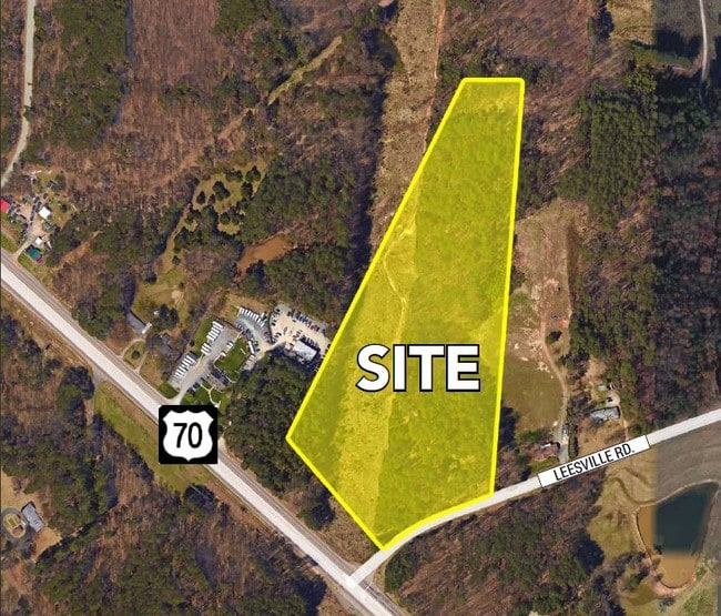
4615 Leesville Rd, Durham, NC 27703

Property Detail
4615 Leesville Rd
164661
PROP-MITCHELL WARREN D & DURHAM DAVID S/LT#01R PL:000200-000374
Agriculturalland
DURHAM
RR
North Carolina
B and X Area of moderate flood hazard, usually the area between the limits of the 100-year and 500-year floods.
1r
2025
13.88 AC
2025
South Durham
001808
Raleigh/Durham
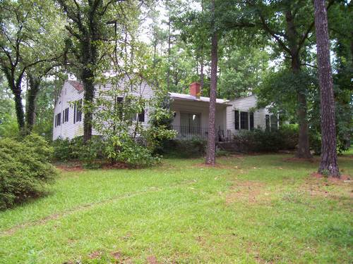
1,664 SF
Durham-Chapel Hill, NC
NEARBY LISTINGS FOR SALE OR LEASE
DEMOGRAPHICS near 4615 Leesville Rd
1 mile
3 mile
5 mile
2025 Total Population
4,986
52,614
110,616
2030 Population
5,362
56,675
118,580
Pop Growth 2025-2030
+ 7.54%
+ 7.72%
+ 7.20%
Average Age
38
40
39
2025 Total Households
2,165
24,355
47,036
HH Growth 2025-2030
+ 7.67%
+ 8.08%
+ 7.57%
Median Household Inc
$128,266
$113,008
$99,797
Avg Household Size
2.30
2.10
2.30
2025 Avg HH Vehicles
2.00
2.00
2.00
Median Home Value
$420,794
$452,753
$420,508
Median Year Built
2010
2010
2006
Nearby Places
Map Layers
Map Styles
 Street
 Aerial
Transit
 Traffic
 Biking
Places
Listings with unknown addresses are not visible on the map
- Restaurants
- Banks
- Shops
- Fitness
- Groceries
SALE & LEASE HISTORY
LISTING DATE
SALE/LEASE

Sep 24, 2016
For Sale
May 04, 2017
For Sale
Nearby Properties
Address
Land Use
TOTAL SIZE
Lot Size
Zoning
Address
Land Use
TOTAL SIZE
Lot Size
Zoning
1,080,486 SF
61.68 AC
SRP
Address
Land Use
TOTAL SIZE
Lot Size
Zoning
677,504 SF
60.32 AC
SRP
Address
Land Use
TOTAL SIZE
Lot Size
Zoning
29.13 AC
CG(D)
Address
Land Use
TOTAL SIZE
Lot Size
Zoning
491,701 SF
124.48 AC
SRP
Address
Land Use
TOTAL SIZE
Lot Size
Zoning
11,670 SF
41.27 AC
RS-M(D)
Address
Land Use
TOTAL SIZE
Lot Size
Zoning
15,252 SF
29.36 AC
RS-M
Address
Land Use
TOTAL SIZE
Lot Size
Zoning
543,777 SF
28.13 AC
RX-4
Address
Land Use
TOTAL SIZE
Lot Size
Zoning
385,640 SF
36.45 AC
RX-4
Address
Land Use
TOTAL SIZE
Lot Size
Zoning
441,283 SF
23.76 AC
PD
Address
Land Use
TOTAL SIZE
Lot Size
Zoning
2,922 SF
30.57 AC
PDR 4.840
Address
Land Use
TOTAL SIZE
Lot Size
Zoning
21.29 AC
CG(D)
Address
Land Use
TOTAL SIZE
Lot Size
Zoning
441,280 SF
48.43 AC
IL
Address
Land Use
TOTAL SIZE
Lot Size
Zoning
431,534 SF
23.20 AC
RX-4
Address
Land Use
TOTAL SIZE
Lot Size
Zoning
370,540 SF
20.79 AC
PD
Address
Land Use
TOTAL SIZE
Lot Size
Zoning
287,656 SF
20.62 AC
PDR-H
Address
Land Use
TOTAL SIZE
Lot Size
Zoning
21.83 AC
OI
Address
Land Use
TOTAL SIZE
Lot Size
Zoning
303,191 SF
19.18 AC
PD
Address
Land Use
TOTAL SIZE
Lot Size
Zoning
407,178 SF
22.57 AC
PD
Address
Land Use
TOTAL SIZE
Lot Size
Zoning
28,632 SF
23.64 AC
PDR 3.990
Address
Land Use
TOTAL SIZE
Lot Size
Zoning
262,391 SF
8 AC
PD
Address
Land Use
TOTAL SIZE
Lot Size
Zoning
278,044 SF
17.79 AC
RX-3
Address
Land Use
TOTAL SIZE
Lot Size
Zoning
267,757 SF
35.89 AC
CX-5
Address
Land Use
TOTAL SIZE
Lot Size
Zoning
456,072 SF
35.73 AC
IP
Address
Land Use
TOTAL SIZE
Lot Size
Zoning
303,290 SF
14.48 AC
RX-3
Address
Land Use
TOTAL SIZE
Lot Size
Zoning
6,180 SF
26.56 AC
RS-M(D)
Address
Land Use
TOTAL SIZE
Lot Size
Zoning
10,572 SF
27.56 AC
RS-M(D)
Address
Land Use
TOTAL SIZE
Lot Size
Zoning
1,524 SF
11.97 AC
CG(D)
Address
Land Use
TOTAL SIZE
Lot Size
Zoning
4,850 SF
14.59 AC
PDR 4.733
Address
Land Use
TOTAL SIZE
Lot Size
Zoning
296,141 SF
14.38 AC
PD
Address
Land Use
TOTAL SIZE
Lot Size
Zoning
451,553 SF
422.05 AC
IL
The World's #1 Commercial Real Estate Marketplace
Connect with us
© 2026 CoStar Group
The information above has been obtained from sources believed reliable. While we do not doubt its accuracy we have not verified it and make no guarantee, warranty or representation about it. It is your responsibility to independently confirm its accuracy and completeness. Any projections, opinions, assumptions, or estimates used are for example only and do not represent the current or future performance of the property. The value of this transaction to you depends on tax and other factors which should be evaluated by your tax, financial, and legal advisors. You and your advisors should conduct a careful, independent investigation of the property to determine to your satisfaction the suitability of the property for your needs.