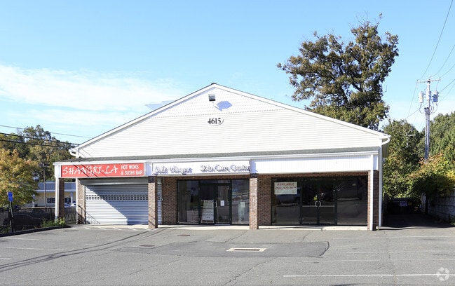
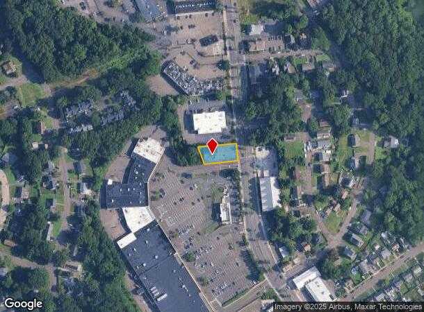
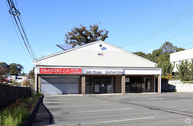
Property Record
4615 Main St, Bridgeport, CT 06606
NEARBY LISTINGS FOR SALE OR LEASE
Property Detail
4615 Main St
BRID-002509-000072A
Fairfield
Commercialbuilding
Connecticut
X
72-a
09001C0427F
0.26 AC
2025
Bridgeport
2025
Westchester/So Connecticut
072600
Bridgeport-Stamford-Norwalk, CT
3,481 SF
DEMOGRAPHICS near 4615 Main St
1 Mile
3 Mile
5 Mile
2024 Total Population
17,946
123,495
261,955
2029 Population
18,189
123,716
262,128
Pop Growth 2024-2029
+ 1.35%
+ 0.18%
+ 0.07%
Average Age
40
38
39
2024 Total Households
6,370
42,088
93,652
HH Growth 2024-2029
+ 1.27%
+ 0.07%
(0.01%)
Median Household Inc
$70,954
$71,710
$70,979
Avg Household Size
2.50
2.70
2.60
2024 Avg HH Vehicles
2.00
2.00
2.00
Median Home Value
$235,464
$312,693
$330,530
Median Year Built
1962
1956
1956
Nearby Places
Map Layers
Map Styles
 Street
 Aerial
- Restaurants
- Banks
- Shops
- Fitness
- Groceries
PUBLIC TRANSPORTATION
COMMUTER RAIL
Bridgeport Station (New Haven Line - Metro-North Commuter Railroad Company (Metro-North))
DRIVE
WALK
Distance
Bridgeport Station (New Haven Line - Metro-North Commuter Railroad Company (Metro-North))
7 min
3.7 mi
DRIVE
WALK
Distance
10 min
5.8 mi
AIRPORT
Tweed/New Haven
DRIVE
WALK
Distance
Tweed/New Haven
37 min
23.7 mi
Westchester County
DRIVE
WALK
Distance
Westchester County
50 min
35.0 mi
Long Island MacArthur
DRIVE
WALK
Distance
Long Island MacArthur
114 min
38.1 mi
Freight Ports
Port of New Haven
DRIVE
WALK
Distance
Port of New Haven
32 min
20.9 mi
SALE & LEASE HISTORY
LISTING DATE
SALE/LEASE

Oct 08, 2018
For Lease
Aug 09, 2023
For Lease
Nearby Properties
Address
Land Use
TOTAL SIZE
Lot Size
Zoning
Address
Land Use
TOTAL SIZE
Lot Size
Zoning
77.74 AC
BC
Address
Land Use
TOTAL SIZE
Lot Size
Zoning
10.42 AC
MDD
Address
Land Use
TOTAL SIZE
Lot Size
Zoning
111,525 SF
Address
Land Use
TOTAL SIZE
Lot Size
Zoning
23.95 AC
RB
Address
Land Use
TOTAL SIZE
Lot Size
Zoning
38.62 AC
Address
Land Use
TOTAL SIZE
Lot Size
Zoning
356,837 SF
8.87 AC
RA
Address
Land Use
TOTAL SIZE
Lot Size
Zoning
120,955 SF
9.37 AC
RA
Address
Land Use
TOTAL SIZE
Lot Size
Zoning
22,848 SF
16.84 AC
IL-2
Address
Land Use
TOTAL SIZE
Lot Size
Zoning
335,633 SF
39.70 AC
R3
Address
Land Use
TOTAL SIZE
Lot Size
Zoning
97,554 SF
6.25 AC
DR
Address
Land Use
TOTAL SIZE
Lot Size
Zoning
10.66 AC
ORR
Address
Land Use
TOTAL SIZE
Lot Size
Zoning
1,482 SF
215.26 AC
R3
Address
Land Use
TOTAL SIZE
Lot Size
Zoning
22.43 AC
R3
Address
Land Use
TOTAL SIZE
Lot Size
Zoning
182,000 SF
12.10 AC
IL-2
Address
Land Use
TOTAL SIZE
Lot Size
Zoning
13.15 AC
ORR
Address
Land Use
TOTAL SIZE
Lot Size
Zoning
3.77 AC
RA
Address
Land Use
TOTAL SIZE
Lot Size
Zoning
79,739 SF
1.53 AC
PDD
Address
Land Use
TOTAL SIZE
Lot Size
Zoning
145,860 SF
2.41 AC
R3
Address
Land Use
TOTAL SIZE
Lot Size
Zoning
14.18 AC
RC
Address
Land Use
TOTAL SIZE
Lot Size
Zoning
630 SF
107.70 AC
RA
Address
Land Use
TOTAL SIZE
Lot Size
Zoning
90 AC
RA
Address
Land Use
TOTAL SIZE
Lot Size
Zoning
101,558 SF
7.74 AC
ORN
Address
Land Use
TOTAL SIZE
Lot Size
Zoning
109,800 SF
1.24 AC
RA
Address
Land Use
TOTAL SIZE
Lot Size
Zoning
8.41 AC
RC
Address
Land Use
TOTAL SIZE
Lot Size
Zoning
11.87 AC
RA
Address
Land Use
TOTAL SIZE
Lot Size
Zoning
78,692 SF
10.79 AC
MFO
Address
Land Use
TOTAL SIZE
Lot Size
Zoning
7.10 AC
RC
Address
Land Use
TOTAL SIZE
Lot Size
Zoning
82,717 SF
34.40 AC
IL2
Address
Land Use
TOTAL SIZE
Lot Size
Zoning
7.30 AC
R-1
Address
Land Use
TOTAL SIZE
Lot Size
Zoning
13.90 AC
IL2
The World's #1 Commercial Real Estate Marketplace
Connect with us
© 2025 CoStar Group
The information above has been obtained from sources believed reliable. While we do not doubt its accuracy we have not verified it and make no guarantee, warranty or representation about it. It is your responsibility to independently confirm its accuracy and completeness. Any projections, opinions, assumptions, or estimates used are for example only and do not represent the current or future performance of the property. The value of this transaction to you depends on tax and other factors which should be evaluated by your tax, financial, and legal advisors. You and your advisors should conduct a careful, independent investigation of the property to determine to your satisfaction the suitability of the property for your needs.