Property Record
4615 Opa Locka Ln, Destin, FL 32541
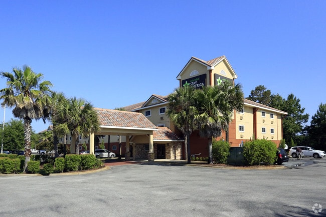

Property Detail
4615 Opa Locka Ln
Crestview-Fort Walton Beach-Destin, FL
EMERALD LAKES COMMERCIAL S/D LOT 3 LESS BEG NW COR LOT 3 S77 DEG E 141.08FT THC S12 DEG W 201.68FT TO N R/W OF OPA-LOCKA LANE THE WLY ALG R/W AND CRV 42.97FT THC CONT ALG CRV 98.47FT TO E R/W TEQUESTA DR THC N12 DEG E ALG R/W 209.99FT TO POB AKA RETA
00-2S-22-0985-0000-0030
Okaloosa
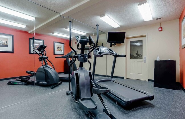
Hotel
Florida
B and X Area of moderate flood hazard, usually the area between the limits of the 100-year and 500-year floods.
3
2025
2.89 AC
2025
Fort Walton Beach
023308
Other Market Areas
31,196 SF
NEARBY LISTINGS FOR SALE OR LEASE
-
-
View all Destin listings for sale on LoopNet.com
DEMOGRAPHICS near 4615 Opa Locka Ln
1 mile
3 mile
5 mile
2025 Total Population
6,181
16,838
34,674
2030 Population
7,022
19,499
40,027
Pop Growth 2025-2030
+ 13.61%
+ 15.80%
+ 15.44%
Average Age
47
49
48
2025 Total Households
2,818
7,975
16,271
HH Growth 2025-2030
+ 13.98%
+ 16.10%
+ 15.82%
Median Household Inc
$100,622
$100,991
$98,862
Avg Household Size
2.20
2.10
2.10
2025 Avg HH Vehicles
2.00
2.00
2.00
Median Home Value
$733,829
$666,456
$589,362
Median Year Built
2000
2001
2000
Nearby Places
Map Layers
Map Styles
 Street
 Aerial
Transit
 Traffic
 Biking
Places
Listings with unknown addresses are not visible on the map
- Restaurants
- Banks
- Shops
- Fitness
- Groceries
PUBLIC TRANSPORTATION
AIRPORT
Eglin AFB/Destin-Ft Walton Beach
Drive
Walk
Distance
Eglin AFB/Destin-Ft Walton Beach
45 min
19.7 mi
Nearby Properties
Address
Land Use
TOTAL SIZE
Lot Size
Zoning
Address
Land Use
TOTAL SIZE
Lot Size
Zoning
619,795 SF
47.80 AC
Address
Land Use
TOTAL SIZE
Lot Size
Zoning
110,181 SF
3.48 AC
Address
Land Use
TOTAL SIZE
Lot Size
Zoning
148,945 SF
12.83 AC
Address
Land Use
TOTAL SIZE
Lot Size
Zoning
125,459 SF
12.57 AC
Address
Land Use
TOTAL SIZE
Lot Size
Zoning
29,385 SF
211.96 AC
Address
Land Use
TOTAL SIZE
Lot Size
Zoning
135,360 SF
16 AC
Address
Land Use
TOTAL SIZE
Lot Size
Zoning
181,240 SF
11.20 AC
Address
Land Use
TOTAL SIZE
Lot Size
Zoning
5.19 AC
GULFFR
Address
Land Use
TOTAL SIZE
Lot Size
Zoning
19,401 SF
6.66 AC
Address
Land Use
TOTAL SIZE
Lot Size
Zoning
138,905 SF
4.01 AC
Address
Land Use
TOTAL SIZE
Lot Size
Zoning
118,963 SF
7.58 AC
Address
Land Use
TOTAL SIZE
Lot Size
Zoning
74,662 SF
6.02 AC
HWY 98
Address
Land Use
TOTAL SIZE
Lot Size
Zoning
223,790 SF
20.75 AC
Address
Land Use
TOTAL SIZE
Lot Size
Zoning
195,622 SF
17.68 AC
Address
Land Use
TOTAL SIZE
Lot Size
Zoning
65,340 SF
1.01 AC
CCMU
Address
Land Use
TOTAL SIZE
Lot Size
Zoning
135,154 SF
15.22 AC
Address
Land Use
TOTAL SIZE
Lot Size
Zoning
28,327 SF
1.45 AC
Address
Land Use
TOTAL SIZE
Lot Size
Zoning
66,001 SF
1.25 AC
HWY 98
Address
Land Use
TOTAL SIZE
Lot Size
Zoning
113,053 SF
7.25 AC
Address
Land Use
TOTAL SIZE
Lot Size
Zoning
231,112 SF
23.03 AC
Address
Land Use
TOTAL SIZE
Lot Size
Zoning
201,131 SF
11.29 AC
Address
Land Use
TOTAL SIZE
Lot Size
Zoning
1.81 AC
GULFFR
Address
Land Use
TOTAL SIZE
Lot Size
Zoning
154,725 SF
15.69 AC
Address
Land Use
TOTAL SIZE
Lot Size
Zoning
33,420 SF
2.56 AC
Address
Land Use
TOTAL SIZE
Lot Size
Zoning
56,505 SF
2.34 AC
Address
Land Use
TOTAL SIZE
Lot Size
Zoning
123,120 SF
4.11 AC
HWY 98
Address
Land Use
TOTAL SIZE
Lot Size
Zoning
74,803 SF
6.97 AC
Address
Land Use
TOTAL SIZE
Lot Size
Zoning
19,487 SF
51.73 AC
Address
Land Use
TOTAL SIZE
Lot Size
Zoning
7,416 SF
25.45 AC
HWY 98
Address
Land Use
TOTAL SIZE
Lot Size
Zoning
22.80 AC
The World's #1 Commercial Real Estate Marketplace
Connect with us
© 2026 CoStar Group
The information above has been obtained from sources believed reliable. While we do not doubt its accuracy we have not verified it and make no guarantee, warranty or representation about it. It is your responsibility to independently confirm its accuracy and completeness. Any projections, opinions, assumptions, or estimates used are for example only and do not represent the current or future performance of the property. The value of this transaction to you depends on tax and other factors which should be evaluated by your tax, financial, and legal advisors. You and your advisors should conduct a careful, independent investigation of the property to determine to your satisfaction the suitability of the property for your needs.