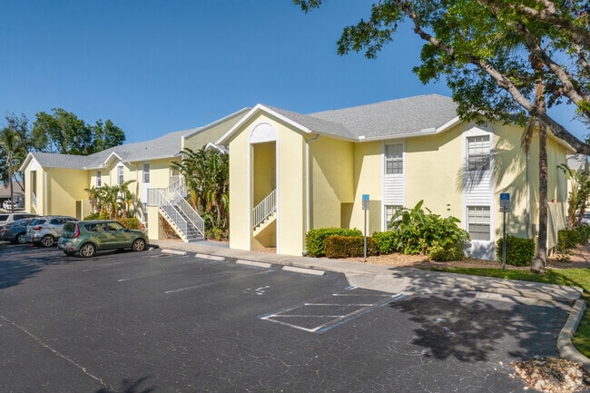
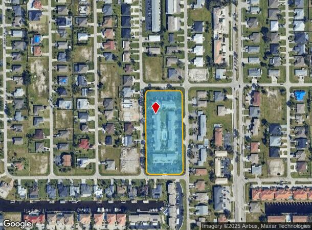
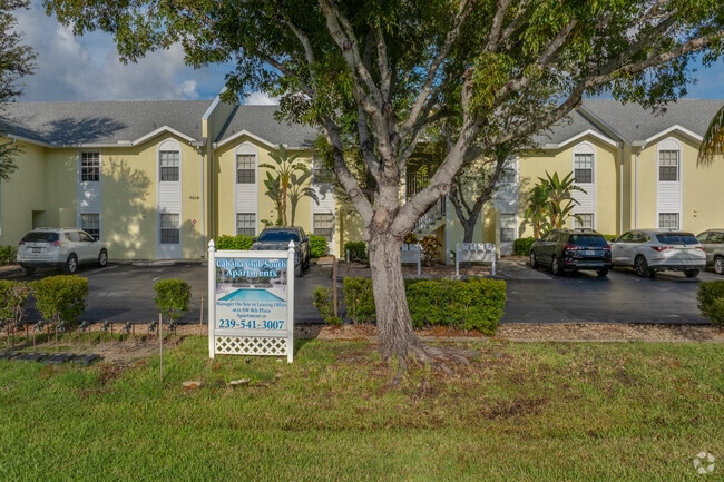
Property Record
4615 Sw 8Th Ct, Cape Coral, FL 33914
NEARBY LISTINGS FOR SALE OR LEASE
Property Detail
4615 Sw 8Th Ct
Cape Coral-Fort Myers, FL
Cape Coral
10-45-23-C3-03371.0010
CAPE CORAL UNIT 65 BLK 3371 PB 21 PG 154 LOTS 1 THRU 28
Multifamilydwelling
Lee
AE
Florida
12071C0403G
1-28
2024
3.26 AC
2025
Pelican
010418
Southwest Florida
52,057 SF
DEMOGRAPHICS near 4615 Sw 8Th Ct
1 Mile
3 Mile
5 Mile
2024 Total Population
10,644
67,762
140,020
2029 Population
12,673
80,946
166,736
Pop Growth 2024-2029
+ 19.06%
+ 19.46%
+ 19.08%
Average Age
48
48
49
2024 Total Households
4,681
29,245
60,680
HH Growth 2024-2029
+ 18.67%
+ 19.06%
+ 18.77%
Median Household Inc
$65,774
$66,527
$66,547
Avg Household Size
2.20
2.30
2.20
2024 Avg HH Vehicles
2.00
2.00
2.00
Median Home Value
$321,570
$325,229
$319,104
Median Year Built
1991
1992
1992
Nearby Places
Map Layers
Map Styles
 Street
 Aerial
- Restaurants
- Banks
- Shops
- Fitness
- Groceries
PUBLIC TRANSPORTATION
AIRPORT
Southwest Florida International
DRIVE
WALK
Distance
Southwest Florida International
32 min
16.8 mi
Punta Gorda
DRIVE
WALK
Distance
Punta Gorda
48 min
29.1 mi
Freight Ports
Port Manatee
DRIVE
WALK
Distance
Port Manatee
128 min
100.8 mi
Nearby Properties
Address
Land Use
TOTAL SIZE
Lot Size
Zoning
Address
Land Use
TOTAL SIZE
Lot Size
Zoning
441,999 SF
19.96 AC
R-3
Address
Land Use
TOTAL SIZE
Lot Size
Zoning
263,280 SF
19.99 AC
RML
Address
Land Use
TOTAL SIZE
Lot Size
Zoning
340,032 SF
30.58 AC
R1-A
Address
Land Use
TOTAL SIZE
Lot Size
Zoning
96,539 SF
74.71 AC
INST
Address
Land Use
TOTAL SIZE
Lot Size
Zoning
212,112 SF
33.92 AC
RD-D
Address
Land Use
TOTAL SIZE
Lot Size
Zoning
744,621 SF
8.01 AC
C1W
Address
Land Use
TOTAL SIZE
Lot Size
Zoning
158,176 SF
20 AC
R-1
Address
Land Use
TOTAL SIZE
Lot Size
Zoning
144,607 SF
20 AC
INS
Address
Land Use
TOTAL SIZE
Lot Size
Zoning
6.09 AC
MR
Address
Land Use
TOTAL SIZE
Lot Size
Zoning
135,838 SF
40 AC
R-1
Address
Land Use
TOTAL SIZE
Lot Size
Zoning
113,239 SF
12.62 AC
R1-D
Address
Land Use
TOTAL SIZE
Lot Size
Zoning
79,839 SF
8.25 AC
C1-D
Address
Land Use
TOTAL SIZE
Lot Size
Zoning
102,906 SF
2.95 AC
C
Address
Land Use
TOTAL SIZE
Lot Size
Zoning
69,261 SF
8.44 AC
WSHP
Address
Land Use
TOTAL SIZE
Lot Size
Zoning
84,145 SF
8.11 AC
C-1
Address
Land Use
TOTAL SIZE
Lot Size
Zoning
58,318 SF
4.99 AC
C
Address
Land Use
TOTAL SIZE
Lot Size
Zoning
74,368 SF
2.32 AC
SC
Address
Land Use
TOTAL SIZE
Lot Size
Zoning
103,490 SF
3.47 AC
C1-D
Address
Land Use
TOTAL SIZE
Lot Size
Zoning
201,687 SF
11.80 AC
C-1
Address
Land Use
TOTAL SIZE
Lot Size
Zoning
86,497 SF
6.20 AC
SC
Address
Land Use
TOTAL SIZE
Lot Size
Zoning
139,446 SF
9.94 AC
C1-D
Address
Land Use
TOTAL SIZE
Lot Size
Zoning
45,809 SF
1.75 AC
SC
Address
Land Use
TOTAL SIZE
Lot Size
Zoning
51,688 SF
3.60 AC
C-1
Address
Land Use
TOTAL SIZE
Lot Size
Zoning
168,937 SF
13.56 AC
C-1
Address
Land Use
TOTAL SIZE
Lot Size
Zoning
67,396 SF
2.02 AC
SC
Address
Land Use
TOTAL SIZE
Lot Size
Zoning
3,327.69 AC
PR
Address
Land Use
TOTAL SIZE
Lot Size
Zoning
54,257 SF
3.34 AC
R-3
Address
Land Use
TOTAL SIZE
Lot Size
Zoning
97,049 SF
1.05 AC
C-1
Address
Land Use
TOTAL SIZE
Lot Size
Zoning
78,297 SF
4.62 AC
P-1
Address
Land Use
TOTAL SIZE
Lot Size
Zoning
51,610 SF
4.67 AC
C1
The World's #1 Commercial Real Estate Marketplace
Connect with us
© 2026 CoStar Group
The information above has been obtained from sources believed reliable. While we do not doubt its accuracy we have not verified it and make no guarantee, warranty or representation about it. It is your responsibility to independently confirm its accuracy and completeness. Any projections, opinions, assumptions, or estimates used are for example only and do not represent the current or future performance of the property. The value of this transaction to you depends on tax and other factors which should be evaluated by your tax, financial, and legal advisors. You and your advisors should conduct a careful, independent investigation of the property to determine to your satisfaction the suitability of the property for your needs.