Property Record
4618 Woodland Dr, Two Rivers, WI 54241

NEARBY LISTINGS FOR SALE OR LEASE
Property Detail
4618 Woodland Dr
Manitowoc, WI
Certified Surv Maps
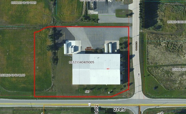
053-233-404-090.05
TRACT 12 OF CSM V25 P147 & TRACT 10 OF CSM V19 P33
Industrialgeneral
Manitowoc
X
Wisconsin
55071C0213E
12
2024
6.19 AC
2024
Wisconsin South Area
010100
Other Market Areas
DEMOGRAPHICS near 4618 Woodland Dr
1 Mile
3 Mile
5 Mile
2024 Total Population
124
14,857
31,284
2029 Population
125
14,955
31,432
Pop Growth 2024-2029
+ 0.81%
+ 0.66%
+ 0.47%
Average Age
44
44
44
2024 Total Households
58
6,835
14,139
HH Growth 2024-2029
0.00%
+ 0.61%
+ 0.46%
Median Household Inc
$63,750
$56,470
$55,376
Avg Household Size
2.10
2.10
2.20
2024 Avg HH Vehicles
2.00
2.00
2.00
Median Home Value
$172,727
$140,351
$148,945
Median Year Built
1979
1964
1961
Nearby Places
Map Layers
Map Styles
 Street
 Aerial
- Restaurants
- Banks
- Shops
- Fitness
- Groceries
Nearby Properties
Address
Land Use
TOTAL SIZE
Lot Size
Zoning
Address
Land Use
TOTAL SIZE
Lot Size
Zoning
97,963 SF
12.33 AC
B3
Address
Land Use
TOTAL SIZE
Lot Size
Zoning
105,564 SF
13.27 AC
Address
Land Use
TOTAL SIZE
Lot Size
Zoning
30,576 SF
11.25 AC
Address
Land Use
TOTAL SIZE
Lot Size
Zoning
69,436 SF
18 AC
Address
Land Use
TOTAL SIZE
Lot Size
Zoning
30.22 AC
I2
Address
Land Use
TOTAL SIZE
Lot Size
Zoning
11.60 AC
Address
Land Use
TOTAL SIZE
Lot Size
Zoning
157,392 SF
7.54 AC
PUD
Address
Land Use
TOTAL SIZE
Lot Size
Zoning
71.56 AC
Address
Land Use
TOTAL SIZE
Lot Size
Zoning
33,012 SF
1.11 AC
B1
Address
Land Use
TOTAL SIZE
Lot Size
Zoning
79,008 SF
11.47 AC
Address
Land Use
TOTAL SIZE
Lot Size
Zoning
82,148 SF
5.34 AC
Address
Land Use
TOTAL SIZE
Lot Size
Zoning
638,600 SF
20.47 AC
I2
Address
Land Use
TOTAL SIZE
Lot Size
Zoning
61,440 SF
4.95 AC
Address
Land Use
TOTAL SIZE
Lot Size
Zoning
83,486 SF
3.82 AC
B2
Address
Land Use
TOTAL SIZE
Lot Size
Zoning
20,696 SF
2.27 AC
B1
Address
Land Use
TOTAL SIZE
Lot Size
Zoning
17,084 SF
3.52 AC
Address
Land Use
TOTAL SIZE
Lot Size
Zoning
37,703 SF
1.76 AC
R4
Address
Land Use
TOTAL SIZE
Lot Size
Zoning
3,700 SF
5.06 AC
R3
Address
Land Use
TOTAL SIZE
Lot Size
Zoning
90,778 SF
3.51 AC
B1
Address
Land Use
TOTAL SIZE
Lot Size
Zoning
60,708 SF
1.91 AC
Address
Land Use
TOTAL SIZE
Lot Size
Zoning
34,578 SF
0.62 AC
PUD
Address
Land Use
TOTAL SIZE
Lot Size
Zoning
46,080 SF
2.01 AC
PUD
Address
Land Use
TOTAL SIZE
Lot Size
Zoning
45,360 SF
1.75 AC
PUD
Address
Land Use
TOTAL SIZE
Lot Size
Zoning
9,776 SF
1.14 AC
OSB
Address
Land Use
TOTAL SIZE
Lot Size
Zoning
84,696 SF
11.69 AC
Address
Land Use
TOTAL SIZE
Lot Size
Zoning
28,262 SF
106.91 AC
Address
Land Use
TOTAL SIZE
Lot Size
Zoning
5.39 AC
I1
Address
Land Use
TOTAL SIZE
Lot Size
Zoning
29,268 SF
1.36 AC
R3
Address
Land Use
TOTAL SIZE
Lot Size
Zoning
46,800 SF
2.06 AC
I2
The World's #1 Commercial Real Estate Marketplace
Connect with us
© 2025 CoStar Group
The information above has been obtained from sources believed reliable. While we do not doubt its accuracy we have not verified it and make no guarantee, warranty or representation about it. It is your responsibility to independently confirm its accuracy and completeness. Any projections, opinions, assumptions, or estimates used are for example only and do not represent the current or future performance of the property. The value of this transaction to you depends on tax and other factors which should be evaluated by your tax, financial, and legal advisors. You and your advisors should conduct a careful, independent investigation of the property to determine to your satisfaction the suitability of the property for your needs.