Property Record
468 Davidson St, Chula Vista, CA 91910
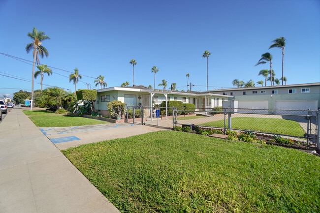
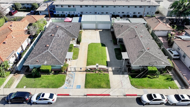
This Property Is For Sale
NEARBY LISTINGS FOR SALE OR LEASE
Property Detail
468 Davidson St
San Diego-Carlsbad, CA
Chula Vista
568-110-11
1/4 SEC 149 LOT 14 POR TR 000505
Multifamilydwelling
San Diego
X
California
06073C1914G
14
2024
0.14 AC
2025
Downtown Chula Vista
012402
San Diego
DEMOGRAPHICS near 468 Davidson St
1 Mile
3 Mile
5 Mile
2024 Total Population
34,857
159,209
424,862
2029 Population
35,119
159,383
424,438
Pop Growth 2024-2029
+ 0.75%
+ 0.11%
(0.10%)
Average Age
39
39
39
2024 Total Households
12,454
50,532
125,715
HH Growth 2024-2029
+ 0.63%
(0.02%)
(0.24%)
Median Household Inc
$67,080
$76,100
$83,248
Avg Household Size
2.70
3.00
3.20
2024 Avg HH Vehicles
2.00
2.00
2.00
Median Home Value
$552,574
$695,658
$707,203
Median Year Built
1966
1966
1973
Nearby Places
- Restaurants
- Banks
- Shops
- Fitness
- Groceries
PUBLIC TRANSPORTATION
TRANSIT/SUBWAY
Bayfront/E Street (Blue Line - San Diego Metropolitan Transit System Trolley (San Diego Trolley))
DRIVE
WALK
Distance
Bayfront/E Street (Blue Line - San Diego Metropolitan Transit System Trolley (San Diego Trolley))
4 min
17 min
0.9 mi
COMMUTER RAIL
San Diego (Santa Fe Depot) (Coaster - San Diego North County Transit District (Coaster/Sprinter/Breeze))
DRIVE
WALK
Distance
San Diego (Santa Fe Depot) (Coaster - San Diego North County Transit District (Coaster/Sprinter/Breeze))
14 min
8.9 mi
AIRPORT
San Diego International
DRIVE
WALK
Distance
San Diego International
17 min
11.5 mi
Freight Ports
Port of San Diego
DRIVE
WALK
Distance
Port of San Diego
12 min
7.5 mi
Nearby Properties
Address
Land Use
TOTAL SIZE
Lot Size
Zoning
Address
Land Use
TOTAL SIZE
Lot Size
Zoning
17.38 AC
UNZ
Address
Land Use
TOTAL SIZE
Lot Size
Zoning
11.42 AC
CP
Address
Land Use
TOTAL SIZE
Lot Size
Zoning
6.55 AC
MXD-2
Address
Land Use
TOTAL SIZE
Lot Size
Zoning
115.70 AC
Marine Ter
Address
Land Use
TOTAL SIZE
Lot Size
Zoning
10.43 AC
RM-2
Address
Land Use
TOTAL SIZE
Lot Size
Zoning
15 AC
UC-14
Address
Land Use
TOTAL SIZE
Lot Size
Zoning
9.84 AC
C
Address
Land Use
TOTAL SIZE
Lot Size
Zoning
19.90 AC
C
Address
Land Use
TOTAL SIZE
Lot Size
Zoning
24.06 AC
R3
Address
Land Use
TOTAL SIZE
Lot Size
Zoning
7.52 AC
MCR-2
Address
Land Use
TOTAL SIZE
Lot Size
Zoning
8.96 AC
UC-4
Address
Land Use
TOTAL SIZE
Lot Size
Zoning
6.03 AC
R3
Address
Land Use
TOTAL SIZE
Lot Size
Zoning
2.81 AC
IP
Address
Land Use
TOTAL SIZE
Lot Size
Zoning
6.85 AC
IL
Address
Land Use
TOTAL SIZE
Lot Size
Zoning
16,410 SF
UNZ
Address
Land Use
TOTAL SIZE
Lot Size
Zoning
6.07 AC
MXD-1
Address
Land Use
TOTAL SIZE
Lot Size
Zoning
4.80 AC
MXD-2
Address
Land Use
TOTAL SIZE
Lot Size
Zoning
Address
Land Use
TOTAL SIZE
Lot Size
Zoning
1.05 AC
C-1
Address
Land Use
TOTAL SIZE
Lot Size
Zoning
9.44 AC
PC
Address
Land Use
TOTAL SIZE
Lot Size
Zoning
0.68 AC
MXU
Address
Land Use
TOTAL SIZE
Lot Size
Zoning
1.43 AC
UC-2
Address
Land Use
TOTAL SIZE
Lot Size
Zoning
86,920 SF
2.38 AC
RM-2
Address
Land Use
TOTAL SIZE
Lot Size
Zoning
1.88 AC
UC-2
Address
Land Use
TOTAL SIZE
Lot Size
Zoning
2.24 AC
MXD-2
Address
Land Use
TOTAL SIZE
Lot Size
Zoning
0.89 AC
MXU
Address
Land Use
TOTAL SIZE
Lot Size
Zoning
1.43 AC
UC-2
Address
Land Use
TOTAL SIZE
Lot Size
Zoning
4.71 AC
R3
Address
Land Use
TOTAL SIZE
Lot Size
Zoning
4.42 AC
MM
Address
Land Use
TOTAL SIZE
Lot Size
Zoning
13.87 AC
MXD-2
The World's #1 Commercial Real Estate Marketplace
Connect with us
© 2025 CoStar Group
The information above has been obtained from sources believed reliable. While we do not doubt its accuracy we have not verified it and make no guarantee, warranty or representation about it. It is your responsibility to independently confirm its accuracy and completeness. Any projections, opinions, assumptions, or estimates used are for example only and do not represent the current or future performance of the property. The value of this transaction to you depends on tax and other factors which should be evaluated by your tax, financial, and legal advisors. You and your advisors should conduct a careful, independent investigation of the property to determine to your satisfaction the suitability of the property for your needs.