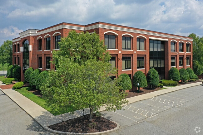
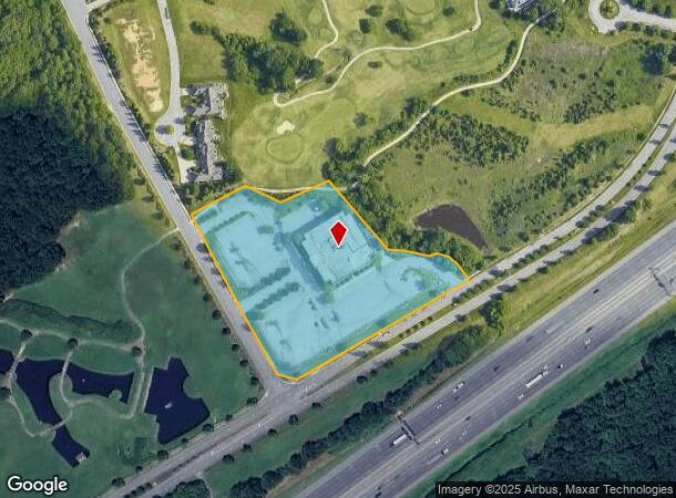
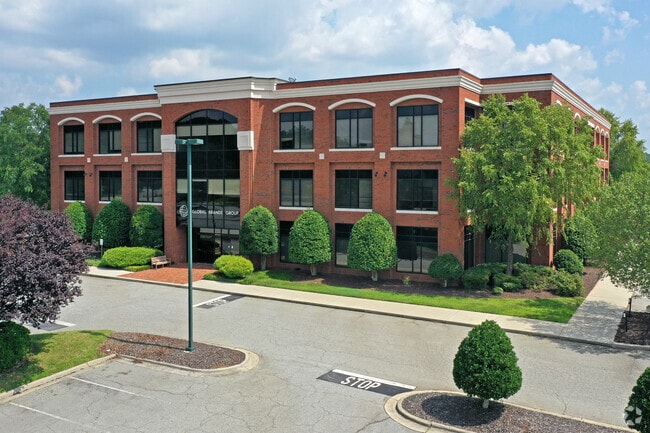
Property Record
4620 Grandover Pkwy, Greensboro, NC 27407
NEARBY LISTINGS FOR SALE OR LEASE
Property Detail
4620 Grandover Pkwy
Greensboro-High Point, NC
Grandover
0082731
C-3 S10-1 PH3 GRANDOVER OFFICE PARK PL:124-34
Officebuilding
Guilford
X
North Carolina
3710784100J
51
2024
5.56 AC
2025
Central Guilford County
016502
Greensboro/Winston-Salem
76,692 SF
DEMOGRAPHICS near 4620 Grandover Pkwy
1 Mile
3 Mile
5 Mile
2024 Total Population
1,043
23,554
97,780
2029 Population
1,053
23,544
97,217
Pop Growth 2024-2029
+ 0.96%
(0.04%)
(0.58%)
Average Age
44
41
39
2024 Total Households
432
9,623
40,673
HH Growth 2024-2029
+ 0.93%
(0.05%)
(0.58%)
Median Household Inc
$70,178
$63,740
$57,670
Avg Household Size
2.40
2.40
2.30
2024 Avg HH Vehicles
2.00
2.00
2.00
Median Home Value
$265,131
$198,811
$169,169
Median Year Built
1983
1987
1987
Nearby Places
- Restaurants
- Banks
- Shops
- Fitness
- Groceries
PUBLIC TRANSPORTATION
COMMUTER RAIL
Greensboro Station (Piedmont - North Carolina by Train (NC Train))
DRIVE
WALK
Distance
Greensboro Station (Piedmont - North Carolina by Train (NC Train))
13 min
8.6 mi
AIRPORT
Piedmont Triad International
DRIVE
WALK
Distance
Piedmont Triad International
23 min
11.6 mi
Nearby Properties
Address
Land Use
TOTAL SIZE
Lot Size
Zoning
Address
Land Use
TOTAL SIZE
Lot Size
Zoning
1,307,155 SF
60.56 AC
C-H
Address
Land Use
TOTAL SIZE
Lot Size
Zoning
341,210 SF
13.43 AC
PUD
Address
Land Use
TOTAL SIZE
Lot Size
Zoning
536,466 SF
46.90 AC
PUD
Address
Land Use
TOTAL SIZE
Lot Size
Zoning
419,281 SF
25.12 AC
CIV
Address
Land Use
TOTAL SIZE
Lot Size
Zoning
228,994 SF
15.59 AC
PUD
Address
Land Use
TOTAL SIZE
Lot Size
Zoning
231,597 SF
8.46 AC
PD-R
Address
Land Use
TOTAL SIZE
Lot Size
Zoning
395,043 SF
15.74 AC
PUD
Address
Land Use
TOTAL SIZE
Lot Size
Zoning
177,780 SF
11.80 AC
PUD
Address
Land Use
TOTAL SIZE
Lot Size
Zoning
403,590 SF
72.06 AC
CIV
Address
Land Use
TOTAL SIZE
Lot Size
Zoning
144,746 SF
8.17 AC
AG
Address
Land Use
TOTAL SIZE
Lot Size
Zoning
272,917 SF
33.57 AC
MS
Address
Land Use
TOTAL SIZE
Lot Size
Zoning
91,414 SF
11.72 AC
C-H
Address
Land Use
TOTAL SIZE
Lot Size
Zoning
87,514 SF
40.62 AC
O
Address
Land Use
TOTAL SIZE
Lot Size
Zoning
89,901 SF
10.65 AC
RM-12
Address
Land Use
TOTAL SIZE
Lot Size
Zoning
79,022 SF
6.52 AC
CIV
Address
Land Use
TOTAL SIZE
Lot Size
Zoning
161,556 SF
47.70 AC
HI
Address
Land Use
TOTAL SIZE
Lot Size
Zoning
64,721 SF
10.65 AC
AG
Address
Land Use
TOTAL SIZE
Lot Size
Zoning
122,137 SF
17.13 AC
RM-8
Address
Land Use
TOTAL SIZE
Lot Size
Zoning
177,850 SF
93.40 AC
AG
Address
Land Use
TOTAL SIZE
Lot Size
Zoning
55,923 SF
37.65 AC
C-M
Address
Land Use
TOTAL SIZE
Lot Size
Zoning
83,617 SF
8.90 AC
RM-18
Address
Land Use
TOTAL SIZE
Lot Size
Zoning
96,720 SF
7.83 AC
RM-18
Address
Land Use
TOTAL SIZE
Lot Size
Zoning
144,843 SF
22.14 AC
MS
Address
Land Use
TOTAL SIZE
Lot Size
Zoning
109,740 SF
6.41 AC
LI
Address
Land Use
TOTAL SIZE
Lot Size
Zoning
123,940 SF
9.34 AC
RM-18
Address
Land Use
TOTAL SIZE
Lot Size
Zoning
90,548 SF
8.69 AC
RM-12
Address
Land Use
TOTAL SIZE
Lot Size
Zoning
27,160 SF
6.16 AC
O
Address
Land Use
TOTAL SIZE
Lot Size
Zoning
84,657 SF
11.90 AC
RM-12
Address
Land Use
TOTAL SIZE
Lot Size
Zoning
154,028 SF
17.91 AC
LI
Address
Land Use
TOTAL SIZE
Lot Size
Zoning
33,510 SF
11.56 AC
GO-M
The World's #1 Commercial Real Estate Marketplace
Connect with us
© 2025 CoStar Group
The information above has been obtained from sources believed reliable. While we do not doubt its accuracy we have not verified it and make no guarantee, warranty or representation about it. It is your responsibility to independently confirm its accuracy and completeness. Any projections, opinions, assumptions, or estimates used are for example only and do not represent the current or future performance of the property. The value of this transaction to you depends on tax and other factors which should be evaluated by your tax, financial, and legal advisors. You and your advisors should conduct a careful, independent investigation of the property to determine to your satisfaction the suitability of the property for your needs.