Property Record
4620 Se 122Nd Ave, Portland, OR 97236
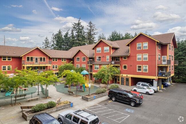


Property Detail
4620 Se 122Nd Ave
R335065
SECTION 14 1S 2E, TL 2000 1.08 ACRES, POTENTIAL ADDITIONAL TAX
Multifamilydwelling
Multnomah
RM2
Oregon
B and X Area of moderate flood hazard, usually the area between the limits of the 100-year and 500-year floods.
1.08 AC
0
Powellhurst-Gilbert
2025
Portland
009001
Portland-Vancouver-Hillsboro, OR-WA
53,564 SF
NEARBY LISTINGS FOR SALE OR LEASE
DEMOGRAPHICS near 4620 Se 122Nd Ave
1 mile
3 mile
5 mile
2025 Total Population
24,964
161,013
416,542
2030 Population
24,641
158,713
411,587
Pop Growth 2025-2030
(1.29%)
(1.43%)
(1.19%)
Average Age
39
40
40
2025 Total Households
8,059
57,588
157,139
HH Growth 2025-2030
(1.66%)
(1.75%)
(1.49%)
Median Household Inc
$67,493
$71,510
$81,848
Avg Household Size
2.80
2.60
2.50
2025 Avg HH Vehicles
2.00
2.00
2.00
Median Home Value
$410,935
$446,729
$491,319
Median Year Built
1977
1973
1972
Nearby Places
Map Layers
Map Styles
 Street
 Aerial
Transit
 Traffic
 Biking
Places
Listings with unknown addresses are not visible on the map
- Restaurants
- Banks
- Shops
- Fitness
- Groceries
PUBLIC TRANSPORTATION
AIRPORT
Portland International
Drive
Walk
Distance
Portland International
19 min
10.0 mi
Freight Ports
Port of Portland
Drive
Walk
Distance
Port of Portland
23 min
13.4 mi
Nearby Properties
Address
Land Use
TOTAL SIZE
Lot Size
Zoning
Address
Land Use
TOTAL SIZE
Lot Size
Zoning
1,024 SF
15.92 AC
OS
Address
Land Use
TOTAL SIZE
Lot Size
Zoning
361,549 SF
39.26 AC
IR
Address
Land Use
TOTAL SIZE
Lot Size
Zoning
250,280 SF
23.86 AC
IR
Address
Land Use
TOTAL SIZE
Lot Size
Zoning
31,878 SF
15.95 AC
IG2
Address
Land Use
TOTAL SIZE
Lot Size
Zoning
317,656 SF
21.94 AC
CX
Address
Land Use
TOTAL SIZE
Lot Size
Zoning
828 SF
23.69 AC
MR2
Address
Land Use
TOTAL SIZE
Lot Size
Zoning
100,217 SF
1.99 AC
R5
Address
Land Use
TOTAL SIZE
Lot Size
Zoning
181,493 SF
3.70 AC
CM1
Address
Land Use
TOTAL SIZE
Lot Size
Zoning
123,716 SF
20.03 AC
LDR-5
Address
Land Use
TOTAL SIZE
Lot Size
Zoning
15.05 AC
CC
Address
Land Use
TOTAL SIZE
Lot Size
Zoning
2,108 SF
12.08 AC
HDR
Address
Land Use
TOTAL SIZE
Lot Size
Zoning
369,835 SF
6.67 AC
IRD
Address
Land Use
TOTAL SIZE
Lot Size
Zoning
99,100 SF
1.31 AC
CS
Address
Land Use
TOTAL SIZE
Lot Size
Zoning
129,462 SF
15.90 AC
R7
Address
Land Use
TOTAL SIZE
Lot Size
Zoning
21,200 SF
16.03 AC
OS
Address
Land Use
TOTAL SIZE
Lot Size
Zoning
258,564 SF
20.56 AC
LDR7
Address
Land Use
TOTAL SIZE
Lot Size
Zoning
64,658 SF
7.79 AC
R5
Address
Land Use
TOTAL SIZE
Lot Size
Zoning
53,774 SF
3 AC
Address
Land Use
TOTAL SIZE
Lot Size
Zoning
105,961 SF
8.76 AC
RM1
Address
Land Use
TOTAL SIZE
Lot Size
Zoning
126,776 SF
5.07 AC
RH
Address
Land Use
TOTAL SIZE
Lot Size
Zoning
82,335 SF
11.34 AC
R5
Address
Land Use
TOTAL SIZE
Lot Size
Zoning
153,648 SF
12.31 AC
CX
Address
Land Use
TOTAL SIZE
Lot Size
Zoning
122,558 SF
9.85 AC
CM2
Address
Land Use
TOTAL SIZE
Lot Size
Zoning
91,064 SF
0.90 AC
RXD
Address
Land Use
TOTAL SIZE
Lot Size
Zoning
121,144 SF
2.30 AC
RM3
Address
Land Use
TOTAL SIZE
Lot Size
Zoning
68,533 SF
4.18 AC
OS
Address
Land Use
TOTAL SIZE
Lot Size
Zoning
121,966 SF
1.97 AC
CM
Address
Land Use
TOTAL SIZE
Lot Size
Zoning
58,558 SF
3.40 AC
RM1
Address
Land Use
TOTAL SIZE
Lot Size
Zoning
154,347 SF
12.35 AC
CE
Address
Land Use
TOTAL SIZE
Lot Size
Zoning
62,592 SF
1.47 AC
RM3
The World's #1 Commercial Real Estate Marketplace
Connect with us
© 2026 CoStar Group
The information above has been obtained from sources believed reliable. While we do not doubt its accuracy we have not verified it and make no guarantee, warranty or representation about it. It is your responsibility to independently confirm its accuracy and completeness. Any projections, opinions, assumptions, or estimates used are for example only and do not represent the current or future performance of the property. The value of this transaction to you depends on tax and other factors which should be evaluated by your tax, financial, and legal advisors. You and your advisors should conduct a careful, independent investigation of the property to determine to your satisfaction the suitability of the property for your needs.