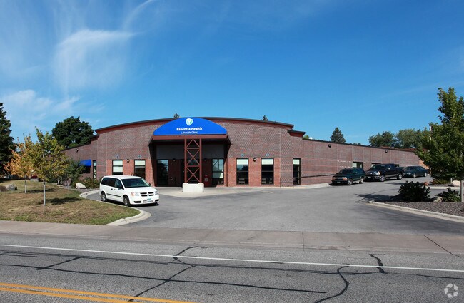
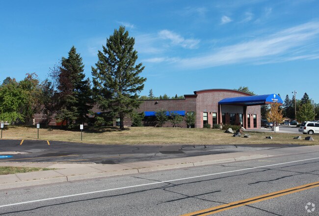
Property Record
4621 E Superior St, Duluth, MN 55804


Property Detail
4621 E Superior St
Duluth, MN-WI
LOTS 1 THRU 6 AND WLY 25 FT OF LOT 7 BLK 45INC LOT 12 BLK 45 AND INCLUDING THAT PART OFVACATED ALLEY ADJACENT SERIAL #
010301002880
Saint Louis
Commercialnec
Minnesota
B and X Area of moderate flood hazard, usually the area between the limits of the 100-year and 500-year floods.
1-7,12
2026
0.26 AC
2024
Lakeside/East End
000600
Duluth
18,078 SF
NEARBY LISTINGS FOR SALE OR LEASE
DEMOGRAPHICS near 4621 E Superior St
1 mile
3 mile
5 mile
2025 Total Population
6,179
26,164
51,575
2030 Population
6,062
25,726
50,821
Pop Growth 2025-2030
(1.89%)
(1.67%)
(1.46%)
Average Age
42
38
38
2025 Total Households
2,514
9,730
21,077
HH Growth 2025-2030
(1.87%)
(1.86%)
(1.65%)
Median Household Inc
$100,144
$92,001
$68,159
Avg Household Size
2.30
2.30
2.10
2025 Avg HH Vehicles
2.00
2.00
2.00
Median Home Value
$271,842
$298,577
$293,060
Median Year Built
1949
1949
1952
Nearby Places
Map Layers
Map Styles
 Street
 Aerial
Layers
 Traffic
 Biking
Places
Listings with unknown addresses are not visible on the map
- Restaurants
- Banks
- Shops
- Fitness
- Groceries
PUBLIC TRANSPORTATION
AIRPORT
Duluth International
Drive
Walk
Distance
Duluth International
28 min
11.8 mi
Freight Ports
Port Milwaukee
Drive
Walk
Distance
Port Milwaukee
460 min
403.4 mi
Nearby Properties
Address
Land Use
TOTAL SIZE
Lot Size
Zoning
Address
Land Use
TOTAL SIZE
Lot Size
Zoning
210,288 SF
146 AC
Address
Land Use
TOTAL SIZE
Lot Size
Zoning
299,603 SF
27.91 AC
Address
Land Use
TOTAL SIZE
Lot Size
Zoning
143,370 SF
8.69 AC
Address
Land Use
TOTAL SIZE
Lot Size
Zoning
148,777 SF
1.19 AC
Address
Land Use
TOTAL SIZE
Lot Size
Zoning
132,316 SF
2.13 AC
Address
Land Use
TOTAL SIZE
Lot Size
Zoning
164,700 SF
2.69 AC
R4
Address
Land Use
TOTAL SIZE
Lot Size
Zoning
77,816 SF
4.43 AC
Address
Land Use
TOTAL SIZE
Lot Size
Zoning
140,999 SF
1.57 AC
Address
Land Use
TOTAL SIZE
Lot Size
Zoning
177,479 SF
1.69 AC
Address
Land Use
TOTAL SIZE
Lot Size
Zoning
50,703 SF
2.07 AC
Address
Land Use
TOTAL SIZE
Lot Size
Zoning
97,573 SF
4.26 AC
R3
Address
Land Use
TOTAL SIZE
Lot Size
Zoning
91,980 SF
0.58 AC
R4
Address
Land Use
TOTAL SIZE
Lot Size
Zoning
50,180 SF
0.67 AC
Address
Land Use
TOTAL SIZE
Lot Size
Zoning
39,615 SF
1.73 AC
Address
Land Use
TOTAL SIZE
Lot Size
Zoning
61,088 SF
4.58 AC
R4
Address
Land Use
TOTAL SIZE
Lot Size
Zoning
177,479 SF
0.77 AC
Address
Land Use
TOTAL SIZE
Lot Size
Zoning
19,127 SF
9.48 AC
Address
Land Use
TOTAL SIZE
Lot Size
Zoning
43,856 SF
2.51 AC
Address
Land Use
TOTAL SIZE
Lot Size
Zoning
58,756 SF
126.18 AC
Address
Land Use
TOTAL SIZE
Lot Size
Zoning
61,088 SF
0.32 AC
Address
Land Use
TOTAL SIZE
Lot Size
Zoning
28,764 SF
0.11 AC
Address
Land Use
TOTAL SIZE
Lot Size
Zoning
29,274 SF
0.28 AC
Address
Land Use
TOTAL SIZE
Lot Size
Zoning
50,322 SF
1.60 AC
R4
Address
Land Use
TOTAL SIZE
Lot Size
Zoning
61,980 SF
2.43 AC
R3
Address
Land Use
TOTAL SIZE
Lot Size
Zoning
45,290 SF
3.07 AC
Address
Land Use
TOTAL SIZE
Lot Size
Zoning
128,100 SF
1.15 AC
Address
Land Use
TOTAL SIZE
Lot Size
Zoning
29,520 SF
0.58 AC
Address
Land Use
TOTAL SIZE
Lot Size
Zoning
177,479 SF
0.56 AC
Address
Land Use
TOTAL SIZE
Lot Size
Zoning
33,438 SF
1.15 AC
R4
The World's #1 Commercial Real Estate Marketplace
Connect with us
© 2026 CoStar Group
The information above has been obtained from sources believed reliable. While we do not doubt its accuracy we have not verified it and make no guarantee, warranty or representation about it. It is your responsibility to independently confirm its accuracy and completeness. Any projections, opinions, assumptions, or estimates used are for example only and do not represent the current or future performance of the property. The value of this transaction to you depends on tax and other factors which should be evaluated by your tax, financial, and legal advisors. You and your advisors should conduct a careful, independent investigation of the property to determine to your satisfaction the suitability of the property for your needs.