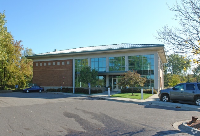
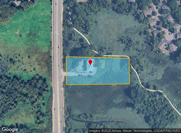
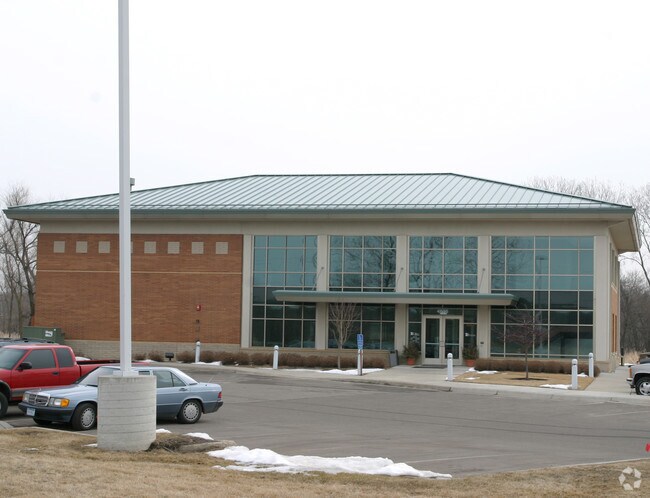
Property Record
4625 Co Rd N, Minnetonka, MN 55345
NEARBY LISTINGS FOR SALE OR LEASE
Property Detail
4625 Co Rd N
Minneapolis-St. Paul-Bloomington, MN-WI
Willow Wood
29-117-22-22-0007
LOT 001 BLOCK 001 B WILLOW WOOD W 263X590X242X589
Commercialnec
Hennepin
AE
Minnesota
27019C0117D
1
2024
3.42 AC
2024
I-394 Corridor
026205
Minneapolis/St Paul
5,394 SF
DEMOGRAPHICS near 4625 Co Rd N
1 Mile
3 Mile
5 Mile
2024 Total Population
5,310
39,821
123,316
2029 Population
5,192
39,139
122,714
Pop Growth 2024-2029
(2.22%)
(1.71%)
(0.49%)
Average Age
43
43
43
2024 Total Households
2,007
15,236
51,830
HH Growth 2024-2029
(2.34%)
(1.93%)
(0.61%)
Median Household Inc
$134,814
$134,629
$110,000
Avg Household Size
2.60
2.50
2.30
2024 Avg HH Vehicles
2.00
2.00
2.00
Median Home Value
$433,406
$459,777
$447,485
Median Year Built
1968
1975
1981
Nearby Places
Map Layers
Map Styles
 Street
 Aerial
- Restaurants
- Banks
- Shops
- Fitness
- Groceries
PUBLIC TRANSPORTATION
AIRPORT
Minneapolis-St Paul International/Wold-Chamberlain
DRIVE
WALK
Distance
Minneapolis-St Paul International/Wold-Chamberlain
28 min
19.2 mi
Freight Ports
Port Milwaukee
DRIVE
WALK
Distance
Port Milwaukee
396 min
353.0 mi
Nearby Properties
Address
Land Use
TOTAL SIZE
Lot Size
Zoning
Address
Land Use
TOTAL SIZE
Lot Size
Zoning
171,900 SF
39.17 AC
B1
Address
Land Use
TOTAL SIZE
Lot Size
Zoning
46,726 SF
2.65 AC
PUD
Address
Land Use
TOTAL SIZE
Lot Size
Zoning
7.06 AC
PUD
Address
Land Use
TOTAL SIZE
Lot Size
Zoning
49,925 SF
18.37 AC
B1
Address
Land Use
TOTAL SIZE
Lot Size
Zoning
7,209 SF
2.53 AC
B1
Address
Land Use
TOTAL SIZE
Lot Size
Zoning
177,644 SF
10.49 AC
I1
Address
Land Use
TOTAL SIZE
Lot Size
Zoning
29,091 SF
34.94 AC
PUD
Address
Land Use
TOTAL SIZE
Lot Size
Zoning
7.82 AC
R4
Address
Land Use
TOTAL SIZE
Lot Size
Zoning
17.67 AC
R4
Address
Land Use
TOTAL SIZE
Lot Size
Zoning
9.29 AC
R4
Address
Land Use
TOTAL SIZE
Lot Size
Zoning
88,948 SF
10.14 AC
B2
Address
Land Use
TOTAL SIZE
Lot Size
Zoning
14.04 AC
R4
Address
Land Use
TOTAL SIZE
Lot Size
Zoning
38,825 SF
5.38 AC
B3
Address
Land Use
TOTAL SIZE
Lot Size
Zoning
47,485 SF
2.19 AC
PUD
Address
Land Use
TOTAL SIZE
Lot Size
Zoning
1,000 SF
14 AC
Address
Land Use
TOTAL SIZE
Lot Size
Zoning
12,993 SF
2.22 AC
R5
Address
Land Use
TOTAL SIZE
Lot Size
Zoning
Address
Land Use
TOTAL SIZE
Lot Size
Zoning
Address
Land Use
TOTAL SIZE
Lot Size
Zoning
123,472 SF
9.07 AC
B2
Address
Land Use
TOTAL SIZE
Lot Size
Zoning
104,969 SF
8.09 AC
I1
Address
Land Use
TOTAL SIZE
Lot Size
Zoning
3.20 AC
Address
Land Use
TOTAL SIZE
Lot Size
Zoning
3.55 AC
Address
Land Use
TOTAL SIZE
Lot Size
Zoning
18,302 SF
3.52 AC
PUD
Address
Land Use
TOTAL SIZE
Lot Size
Zoning
28,134 SF
2.70 AC
PUD
Address
Land Use
TOTAL SIZE
Lot Size
Zoning
62,862 SF
7.91 AC
B2
Address
Land Use
TOTAL SIZE
Lot Size
Zoning
21,208 SF
3.59 AC
B1
Address
Land Use
TOTAL SIZE
Lot Size
Zoning
5.84 AC
R4
Address
Land Use
TOTAL SIZE
Lot Size
Zoning
16,986 SF
1.77 AC
PUD
Address
Land Use
TOTAL SIZE
Lot Size
Zoning
2.72 AC
Address
Land Use
TOTAL SIZE
Lot Size
Zoning
63,098 SF
6.06 AC
I1
The World's #1 Commercial Real Estate Marketplace
Connect with us
© 2025 CoStar Group
The information above has been obtained from sources believed reliable. While we do not doubt its accuracy we have not verified it and make no guarantee, warranty or representation about it. It is your responsibility to independently confirm its accuracy and completeness. Any projections, opinions, assumptions, or estimates used are for example only and do not represent the current or future performance of the property. The value of this transaction to you depends on tax and other factors which should be evaluated by your tax, financial, and legal advisors. You and your advisors should conduct a careful, independent investigation of the property to determine to your satisfaction the suitability of the property for your needs.