Property Record
4626 32Nd St, San Diego, CA 92116
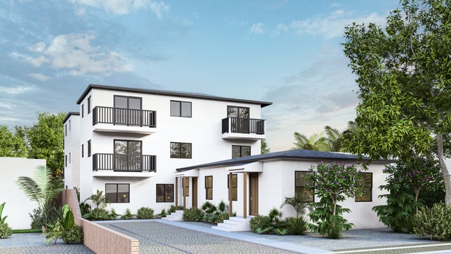


This Property Is For Sale
NEARBY LISTINGS FOR SALE OR LEASE
Property Detail
4626 32Nd St
San Diego-Carlsbad, CA
Normal Heights
439-420-15
BLK 36 LOT 23 TR 000985
Multifamilydwelling
San Diego
X
California
06073C1619G
23
2024
0.14 AC
2025
Normal Heights
001802
San Diego
1,525 SF
DEMOGRAPHICS near 4626 32Nd St
1 Mile
3 Mile
5 Mile
2024 Total Population
40,690
253,572
589,288
2029 Population
41,027
255,452
593,737
Pop Growth 2024-2029
+ 0.83%
+ 0.74%
+ 0.75%
Average Age
37
38
38
2024 Total Households
20,534
112,112
237,992
HH Growth 2024-2029
+ 0.71%
+ 0.74%
+ 0.83%
Median Household Inc
$86,831
$93,488
$92,216
Avg Household Size
1.90
2.20
2.30
2024 Avg HH Vehicles
1.00
2.00
2.00
Median Home Value
$776,515
$840,653
$819,160
Median Year Built
1973
1973
1974
Nearby Places
Map Layers
Map Styles
 Street
 Aerial
- Restaurants
- Banks
- Shops
- Fitness
- Groceries
PUBLIC TRANSPORTATION
COMMUTER RAIL
San Diego (Santa Fe Depot) (Coaster - San Diego North County Transit District (Coaster/Sprinter/Breeze))
DRIVE
WALK
Distance
San Diego (Santa Fe Depot) (Coaster - San Diego North County Transit District (Coaster/Sprinter/Breeze))
12 min
6.0 mi
Old Town Transit Center (Coaster - San Diego North County Transit District (Coaster/Sprinter/Breeze))
DRIVE
WALK
Distance
Old Town Transit Center (Coaster - San Diego North County Transit District (Coaster/Sprinter/Breeze))
11 min
6.1 mi
AIRPORT
San Diego International
DRIVE
WALK
Distance
San Diego International
11 min
5.0 mi
Freight Ports
Port of San Diego
DRIVE
WALK
Distance
Port of San Diego
14 min
6.2 mi
Nearby Properties
Address
Land Use
TOTAL SIZE
Lot Size
Zoning
Address
Land Use
TOTAL SIZE
Lot Size
Zoning
30,000 SF
62.51 AC
MVPD-MV-CR
Address
Land Use
TOTAL SIZE
Lot Size
Zoning
4,774 SF
74.75 AC
RM-2-5
Address
Land Use
TOTAL SIZE
Lot Size
Zoning
17.88 AC
CO-1-2
Address
Land Use
TOTAL SIZE
Lot Size
Zoning
107.28 AC
UNZONED
Address
Land Use
TOTAL SIZE
Lot Size
Zoning
2.53 AC
EMX-1
Address
Land Use
TOTAL SIZE
Lot Size
Zoning
4.41 AC
CC-3-8
Address
Land Use
TOTAL SIZE
Lot Size
Zoning
1.51 AC
CC-3-9
Address
Land Use
TOTAL SIZE
Lot Size
Zoning
RM-4-10
Address
Land Use
TOTAL SIZE
Lot Size
Zoning
6.96 AC
MVPD-MVR-4
Address
Land Use
TOTAL SIZE
Lot Size
Zoning
18.70 AC
RS-1-7
Address
Land Use
TOTAL SIZE
Lot Size
Zoning
19.25 AC
CC-3-5
Address
Land Use
TOTAL SIZE
Lot Size
Zoning
15.37 AC
CC-3-8
Address
Land Use
TOTAL SIZE
Lot Size
Zoning
5.02 AC
CC-3-8
Address
Land Use
TOTAL SIZE
Lot Size
Zoning
54,240 SF
8.18 AC
MVPD-MVR-2
Address
Land Use
TOTAL SIZE
Lot Size
Zoning
2.50 AC
MVPD-MV-CO
Address
Land Use
TOTAL SIZE
Lot Size
Zoning
5.35 AC
MVPD-MV-CR
Address
Land Use
TOTAL SIZE
Lot Size
Zoning
3.97 AC
C
Address
Land Use
TOTAL SIZE
Lot Size
Zoning
7.69 AC
MVPD-MV-M/
Address
Land Use
TOTAL SIZE
Lot Size
Zoning
13.04 AC
RM-2-5
Address
Land Use
TOTAL SIZE
Lot Size
Zoning
7.19 AC
MVPD-MV-M/
Address
Land Use
TOTAL SIZE
Lot Size
Zoning
17.35 AC
C-6
Address
Land Use
TOTAL SIZE
Lot Size
Zoning
902,919 SF
45.23 AC
MVPD-MV-CR
Address
Land Use
TOTAL SIZE
Lot Size
Zoning
2.90 AC
MVPD-MV-CR
Address
Land Use
TOTAL SIZE
Lot Size
Zoning
1.99 AC
EMX-1
Address
Land Use
TOTAL SIZE
Lot Size
Zoning
1.81 AC
EMX-1
Address
Land Use
TOTAL SIZE
Lot Size
Zoning
6.68 AC
RM-3-7
Address
Land Use
TOTAL SIZE
Lot Size
Zoning
16.91 AC
EMX-1
Address
Land Use
TOTAL SIZE
Lot Size
Zoning
3.36 AC
RM-4-10
Address
Land Use
TOTAL SIZE
Lot Size
Zoning
194,809 SF
19.82 AC
MVPD-MV-M/
Address
Land Use
TOTAL SIZE
Lot Size
Zoning
19.67 AC
RM-2-5
The World's #1 Commercial Real Estate Marketplace
Connect with us
© 2025 CoStar Group
The information above has been obtained from sources believed reliable. While we do not doubt its accuracy we have not verified it and make no guarantee, warranty or representation about it. It is your responsibility to independently confirm its accuracy and completeness. Any projections, opinions, assumptions, or estimates used are for example only and do not represent the current or future performance of the property. The value of this transaction to you depends on tax and other factors which should be evaluated by your tax, financial, and legal advisors. You and your advisors should conduct a careful, independent investigation of the property to determine to your satisfaction the suitability of the property for your needs.