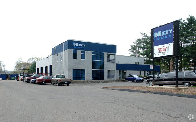
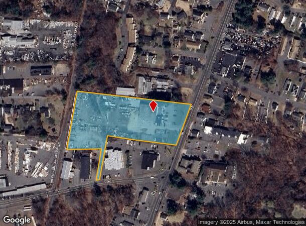
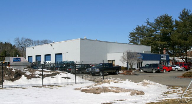
Property Record
463 East St, Plainville, CT 06062
NEARBY LISTINGS FOR SALE OR LEASE
Property Detail
463 East St
PLAI-000042-L000000-000024-000001
Hartford
Parkingstructure
Connecticut
X
24.1
09003C0488G
4.03 AC
2025
Southwest Outlying
2025
Hartford
420500
Hartford-West Hartford-East Hartford, CT
14,613 SF
DEMOGRAPHICS near 463 East St
1 Mile
3 Mile
5 Mile
2024 Total Population
6,467
43,411
151,480
2029 Population
6,442
43,399
150,959
Pop Growth 2024-2029
(0.39%)
(0.03%)
(0.34%)
Average Age
44
43
42
2024 Total Households
2,842
18,899
63,006
HH Growth 2024-2029
(0.42%)
(0.06%)
(0.36%)
Median Household Inc
$76,014
$75,909
$70,924
Avg Household Size
2.20
2.20
2.30
2024 Avg HH Vehicles
2.00
2.00
2.00
Median Home Value
$249,314
$245,519
$245,864
Median Year Built
1970
1971
1964
Nearby Places
Map Layers
Map Styles
 Street
 Aerial
- Restaurants
- Banks
- Shops
- Fitness
- Groceries
PUBLIC TRANSPORTATION
COMMUTER RAIL
DRIVE
WALK
Distance
13 min
8.0 mi
DRIVE
WALK
Distance
13 min
8.0 mi
AIRPORT
Tweed/New Haven
DRIVE
WALK
Distance
Tweed/New Haven
44 min
29.4 mi
Bradley International
DRIVE
WALK
Distance
Bradley International
46 min
30.3 mi
Freight Ports
Port of New Haven
DRIVE
WALK
Distance
Port of New Haven
39 min
26.8 mi
Nearby Properties
Address
Land Use
TOTAL SIZE
Lot Size
Zoning
Address
Land Use
TOTAL SIZE
Lot Size
Zoning
77,001 SF
54.59 AC
IP-1
Address
Land Use
TOTAL SIZE
Lot Size
Zoning
100,304 SF
28.80 AC
IP-1
Address
Land Use
TOTAL SIZE
Lot Size
Zoning
134,488 SF
63.26 AC
GC
Address
Land Use
TOTAL SIZE
Lot Size
Zoning
138.27 AC
S1
Address
Land Use
TOTAL SIZE
Lot Size
Zoning
64,822 SF
9.47 AC
TP
Address
Land Use
TOTAL SIZE
Lot Size
Zoning
58,473 SF
18.20 AC
IP-1
Address
Land Use
TOTAL SIZE
Lot Size
Zoning
145,719 SF
17.90 AC
R-15
Address
Land Use
TOTAL SIZE
Lot Size
Zoning
395,492 SF
54.09 AC
R-20/2
Address
Land Use
TOTAL SIZE
Lot Size
Zoning
114,375 SF
12.72 AC
IP-1
Address
Land Use
TOTAL SIZE
Lot Size
Zoning
330,400 SF
36.90 AC
IP-1
Address
Land Use
TOTAL SIZE
Lot Size
Zoning
28.47 AC
R-10
Address
Land Use
TOTAL SIZE
Lot Size
Zoning
288,827 SF
24.01 AC
RI
Address
Land Use
TOTAL SIZE
Lot Size
Zoning
502,440 SF
27.87 AC
I-2
Address
Land Use
TOTAL SIZE
Lot Size
Zoning
17.62 AC
B
Address
Land Use
TOTAL SIZE
Lot Size
Zoning
29.05 AC
R-20
Address
Land Use
TOTAL SIZE
Lot Size
Zoning
149,912 SF
13.66 AC
B
Address
Land Use
TOTAL SIZE
Lot Size
Zoning
3,084 SF
14.90 AC
BG
Address
Land Use
TOTAL SIZE
Lot Size
Zoning
133,720 SF
7.34 AC
IP-1
Address
Land Use
TOTAL SIZE
Lot Size
Zoning
19 AC
GI
Address
Land Use
TOTAL SIZE
Lot Size
Zoning
16.04 AC
B
Address
Land Use
TOTAL SIZE
Lot Size
Zoning
150,972 SF
9.99 AC
I-1
Address
Land Use
TOTAL SIZE
Lot Size
Zoning
98,463 SF
5.01 AC
I-1
Address
Land Use
TOTAL SIZE
Lot Size
Zoning
106,336 SF
7.63 AC
B2
Address
Land Use
TOTAL SIZE
Lot Size
Zoning
109,212 SF
20.15 AC
B
Address
Land Use
TOTAL SIZE
Lot Size
Zoning
95,940 SF
12 AC
B
Address
Land Use
TOTAL SIZE
Lot Size
Zoning
12.28 AC
R-20/2
Address
Land Use
TOTAL SIZE
Lot Size
Zoning
40 AC
I-2
Address
Land Use
TOTAL SIZE
Lot Size
Zoning
101,495 SF
9.74 AC
B
Address
Land Use
TOTAL SIZE
Lot Size
Zoning
67,503 SF
2.53 AC
B
Address
Land Use
TOTAL SIZE
Lot Size
Zoning
56,734 SF
8.83 AC
R-12
The World's #1 Commercial Real Estate Marketplace
Connect with us
© 2025 CoStar Group
The information above has been obtained from sources believed reliable. While we do not doubt its accuracy we have not verified it and make no guarantee, warranty or representation about it. It is your responsibility to independently confirm its accuracy and completeness. Any projections, opinions, assumptions, or estimates used are for example only and do not represent the current or future performance of the property. The value of this transaction to you depends on tax and other factors which should be evaluated by your tax, financial, and legal advisors. You and your advisors should conduct a careful, independent investigation of the property to determine to your satisfaction the suitability of the property for your needs.