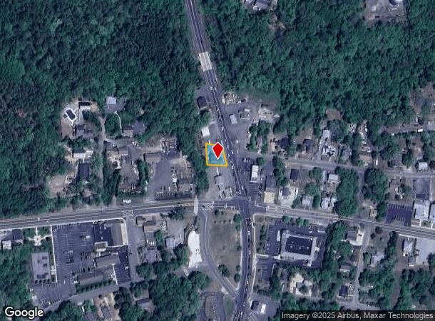
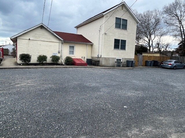
Property Record
463 Route 9, Waretown, NJ 08758
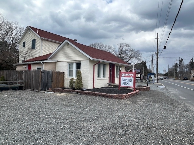
This Property Is For Sale
NEARBY LISTINGS FOR SALE OR LEASE
Property Detail
463 Route 9
21-00045-0000-00001-02
81X82 BARBER SHOP
Commercialnec
Ocean
X
New Jersey
34029C0412F
1.2
2024
0.15 AC
2025
Ocean County
733002
Northern New Jersey
2,300 SF
New York-Jersey City-White Plains, NY-NJ
DEMOGRAPHICS near 463 Route 9
1 Mile
3 Mile
5 Mile
2024 Total Population
3,648
21,463
53,859
2029 Population
4,009
23,342
57,589
Pop Growth 2024-2029
+ 9.90%
+ 8.75%
+ 6.93%
Average Age
44
44
43
2024 Total Households
1,529
8,757
21,071
HH Growth 2024-2029
+ 8.89%
+ 7.99%
+ 6.26%
Median Household Inc
$85,548
$88,651
$86,405
Avg Household Size
2.40
2.40
2.50
2024 Avg HH Vehicles
2.00
2.00
2.00
Median Home Value
$346,909
$351,921
$327,764
Median Year Built
1980
1983
1984
Nearby Places
- Restaurants
- Banks
- Shops
- Fitness
- Groceries
Nearby Properties
Address
Land Use
TOTAL SIZE
Lot Size
Zoning
Address
Land Use
TOTAL SIZE
Lot Size
Zoning
139.60 AC
M6
Address
Land Use
TOTAL SIZE
Lot Size
Zoning
85.65 AC
R40
Address
Land Use
TOTAL SIZE
Lot Size
Zoning
528.70 AC
M6
Address
Land Use
TOTAL SIZE
Lot Size
Zoning
15.27 AC
C-2
Address
Land Use
TOTAL SIZE
Lot Size
Zoning
46.40 AC
ML-4
Address
Land Use
TOTAL SIZE
Lot Size
Zoning
85.65 AC
R40
Address
Land Use
TOTAL SIZE
Lot Size
Zoning
2.76 AC
TC
Address
Land Use
TOTAL SIZE
Lot Size
Zoning
15.12 AC
R-2
Address
Land Use
TOTAL SIZE
Lot Size
Zoning
9.32 AC
TCO+
Address
Land Use
TOTAL SIZE
Lot Size
Zoning
6,600 SF
10.67 AC
PRD
Address
Land Use
TOTAL SIZE
Lot Size
Zoning
11.24 AC
R-2
Address
Land Use
TOTAL SIZE
Lot Size
Zoning
9.65 AC
R-75
Address
Land Use
TOTAL SIZE
Lot Size
Zoning
37.70 AC
TCMX
Address
Land Use
TOTAL SIZE
Lot Size
Zoning
23.70 AC
BCWD
Address
Land Use
TOTAL SIZE
Lot Size
Zoning
89.90 AC
R-2
Address
Land Use
TOTAL SIZE
Lot Size
Zoning
56.23 AC
BC
Address
Land Use
TOTAL SIZE
Lot Size
Zoning
2,557 SF
633.96 AC
Address
Land Use
TOTAL SIZE
Lot Size
Zoning
18.15 AC
TCMX
Address
Land Use
TOTAL SIZE
Lot Size
Zoning
4,230 SF
10.65 AC
CPHD
Address
Land Use
TOTAL SIZE
Lot Size
Zoning
40 AC
TCEC
Address
Land Use
TOTAL SIZE
Lot Size
Zoning
4.85 AC
CPHD
Address
Land Use
TOTAL SIZE
Lot Size
Zoning
18,980 SF
4.19 AC
TCEC
Address
Land Use
TOTAL SIZE
Lot Size
Zoning
3.34 AC
C-1
Address
Land Use
TOTAL SIZE
Lot Size
Zoning
6.25 AC
C100
Address
Land Use
TOTAL SIZE
Lot Size
Zoning
16,992 SF
31.88 AC
FO
Address
Land Use
TOTAL SIZE
Lot Size
Zoning
13,092 SF
1.79 AC
C-2
Address
Land Use
TOTAL SIZE
Lot Size
Zoning
6.39 AC
ML-1
Address
Land Use
TOTAL SIZE
Lot Size
Zoning
6,976 SF
1.29 AC
C150
Address
Land Use
TOTAL SIZE
Lot Size
Zoning
4.70 AC
ML5
Address
Land Use
TOTAL SIZE
Lot Size
Zoning
31.49 AC
M6
The World's #1 Commercial Real Estate Marketplace
Connect with us
© 2025 CoStar Group
The information above has been obtained from sources believed reliable. While we do not doubt its accuracy we have not verified it and make no guarantee, warranty or representation about it. It is your responsibility to independently confirm its accuracy and completeness. Any projections, opinions, assumptions, or estimates used are for example only and do not represent the current or future performance of the property. The value of this transaction to you depends on tax and other factors which should be evaluated by your tax, financial, and legal advisors. You and your advisors should conduct a careful, independent investigation of the property to determine to your satisfaction the suitability of the property for your needs.