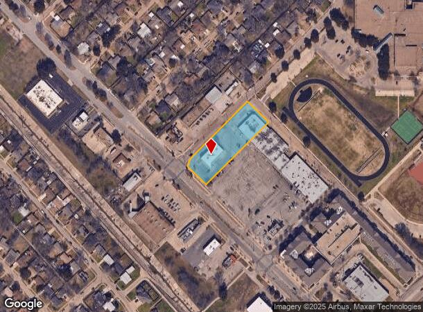
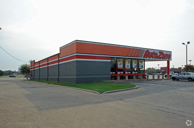
Property Record
4630 Gus Thomasson Rd, Mesquite, TX 75150

NEARBY LISTINGS FOR SALE OR LEASE
Property Detail
4630 Gus Thomasson Rd
38048500250019900
Country Club Ests 2
Storebuilding
COUNTRY CLUB ESTS 2 SHEET 2A TR 12 IMPTS ONLY CO-DALLAS 04850025001990 33804850025
X
Dallas
48113C0360L
Texas
2024
1
2025
Northeast Dallas
018001
Dallas/Ft Worth
5,400 SF
Dallas-Fort Worth-Arlington, TX
DEMOGRAPHICS near 4630 Gus Thomasson Rd
1 Mile
3 Mile
5 Mile
2024 Total Population
17,880
140,943
323,472
2029 Population
17,525
138,827
319,003
Pop Growth 2024-2029
(1.99%)
(1.50%)
(1.38%)
Average Age
35
36
36
2024 Total Households
5,382
49,286
113,003
HH Growth 2024-2029
(2.23%)
(1.68%)
(1.57%)
Median Household Inc
$60,224
$54,362
$58,021
Avg Household Size
3.20
2.80
2.80
2024 Avg HH Vehicles
2.00
2.00
2.00
Median Home Value
$171,689
$197,597
$225,424
Median Year Built
1963
1974
1974
Nearby Places
Map Layers
Map Styles
 Street
 Aerial
- Restaurants
- Banks
- Shops
- Fitness
- Groceries
PUBLIC TRANSPORTATION
AIRPORT
Dallas Love Field
DRIVE
WALK
Distance
Dallas Love Field
29 min
16.6 mi
Dallas-Fort Worth International
DRIVE
WALK
Distance
Dallas-Fort Worth International
42 min
32.2 mi
Nearby Properties
Address
Land Use
TOTAL SIZE
Lot Size
Zoning
Address
Land Use
TOTAL SIZE
Lot Size
Zoning
567,463 SF
19.43 AC
Z31
Address
Land Use
TOTAL SIZE
Lot Size
Zoning
351,901 SF
11.84 AC
Z239
Address
Land Use
TOTAL SIZE
Lot Size
Zoning
491,903 SF
22.48 AC
Z164
Address
Land Use
TOTAL SIZE
Lot Size
Zoning
352,187 SF
20.32 AC
Z237
Address
Land Use
TOTAL SIZE
Lot Size
Zoning
386,240 SF
20.03 AC
Z237
Address
Land Use
TOTAL SIZE
Lot Size
Zoning
588,625 SF
29.01 AC
Z109
Address
Land Use
TOTAL SIZE
Lot Size
Zoning
284,990 SF
24.80 AC
Z298
Address
Land Use
TOTAL SIZE
Lot Size
Zoning
555,510 SF
32.62 AC
Z31
Address
Land Use
TOTAL SIZE
Lot Size
Zoning
509,014 SF
30.82 AC
Z31
Address
Land Use
TOTAL SIZE
Lot Size
Zoning
236,812 SF
13.91 AC
Z237
Address
Land Use
TOTAL SIZE
Lot Size
Zoning
298,038 SF
9.06 AC
Z59
Address
Land Use
TOTAL SIZE
Lot Size
Zoning
298,255 SF
15.59 AC
Z237
Address
Land Use
TOTAL SIZE
Lot Size
Zoning
161,796 SF
14.84 AC
Z239
Address
Land Use
TOTAL SIZE
Lot Size
Zoning
242,741 SF
14.25 AC
Z237
Address
Land Use
TOTAL SIZE
Lot Size
Zoning
263,564 SF
12.71 AC
Z237
Address
Land Use
TOTAL SIZE
Lot Size
Zoning
244,575 SF
9.91 AC
Z164
Address
Land Use
TOTAL SIZE
Lot Size
Zoning
441,696 SF
30.72 AC
Z31
Address
Land Use
TOTAL SIZE
Lot Size
Zoning
263,968 SF
11.51 AC
Z237
Address
Land Use
TOTAL SIZE
Lot Size
Zoning
174,353 SF
12.64 AC
Z248
Address
Land Use
TOTAL SIZE
Lot Size
Zoning
284,470 SF
25.31 AC
Z31
Address
Land Use
TOTAL SIZE
Lot Size
Zoning
116,162 SF
228.26 AC
Z372
Address
Land Use
TOTAL SIZE
Lot Size
Zoning
388,800 SF
28.99 AC
Z122
Address
Land Use
TOTAL SIZE
Lot Size
Zoning
289,172 SF
12.56 AC
Z164
Address
Land Use
TOTAL SIZE
Lot Size
Zoning
206,646 SF
10.35 AC
Z237
Address
Land Use
TOTAL SIZE
Lot Size
Zoning
177,784 SF
19.51 AC
Z237
Address
Land Use
TOTAL SIZE
Lot Size
Zoning
228,857 SF
21.91 AC
Z298
Address
Land Use
TOTAL SIZE
Lot Size
Zoning
205,620 SF
9.03 AC
Z237
Address
Land Use
TOTAL SIZE
Lot Size
Zoning
110,708 SF
16.79 AC
Z298
Address
Land Use
TOTAL SIZE
Lot Size
Zoning
190,106 SF
12.31 AC
Z160
Address
Land Use
TOTAL SIZE
Lot Size
Zoning
249,764 SF
11.43 AC
Z237
The World's #1 Commercial Real Estate Marketplace
Connect with us
© 2025 CoStar Group
The information above has been obtained from sources believed reliable. While we do not doubt its accuracy we have not verified it and make no guarantee, warranty or representation about it. It is your responsibility to independently confirm its accuracy and completeness. Any projections, opinions, assumptions, or estimates used are for example only and do not represent the current or future performance of the property. The value of this transaction to you depends on tax and other factors which should be evaluated by your tax, financial, and legal advisors. You and your advisors should conduct a careful, independent investigation of the property to determine to your satisfaction the suitability of the property for your needs.