Property Record
4630 Pine Ridge Rd, Naples, FL 34119

Save to a Folder
{{folder.Name}}
{{folder.ListingIds.length}} Properties
{{folder.ListingIds.length}} Property
Create a New Folder
Property Detail
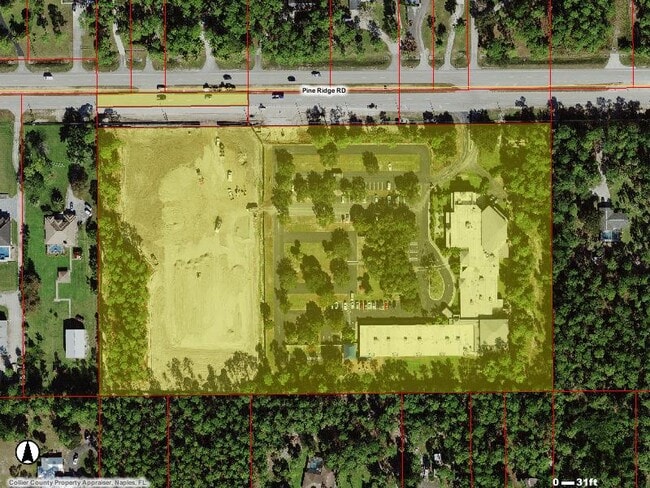
4630 Pine Ridge Rd
37926120008
GOLDEN GATE EST UNIT 26 TR 64, 65 & 68,LESS S 45FT OF N 75FT OF TR 64, LESS N 75FT OF TR 65 AND TR 68
Religious
Collier
E
Florida
AH Areas with a 1% annual chance of shallow flooding, usually in the form of a pond, withan average depth ranging from 1 to 3 feet. These areas have a 26% chance of flooding over the life of a 30-year mortgage.
13.52 AC
0
Golden Gate
2025
Southwest Florida
010408
Naples-Marco Island, FL
56,819 SF
NEARBY LISTINGS FOR SALE OR LEASE
-
-
View all Naples listings for sale on LoopNet.com
DEMOGRAPHICS near 4630 Pine Ridge Rd
1 mile
3 mile
5 mile
2025 Total Population
3,248
43,254
121,809
2030 Population
3,338
44,897
129,434
Pop Growth 2025-2030
+ 2.77%
+ 3.80%
+ 6.26%
Average Age
38
42
45
2025 Total Households
1,087
14,986
48,361
HH Growth 2025-2030
+ 1.56%
+ 3.31%
+ 5.91%
Median Household Inc
$67,951
$82,509
$88,160
Avg Household Size
2.80
2.70
2.40
2025 Avg HH Vehicles
2.00
2.00
2.00
Median Home Value
$741,007
$531,036
$544,091
Median Year Built
1990
1994
1998
Nearby Places
Map Layers
Map Styles
 Street
 Aerial
Layers
 Traffic
 Biking
Places
Listings with unknown addresses are not visible on the map
- Restaurants
- Banks
- Shops
- Fitness
- Groceries
PUBLIC TRANSPORTATION
AIRPORT
Southwest Florida International
Drive
Walk
Distance
Southwest Florida International
38 min
29.6 mi
Freight Ports
Port Everglades
Drive
Walk
Distance
Port Everglades
118 min
103.9 mi
Nearby Properties
Address
Land Use
TOTAL SIZE
Lot Size
Zoning
Address
Land Use
TOTAL SIZE
Lot Size
Zoning
371,089 SF
27.48 AC
PUD
Address
Land Use
TOTAL SIZE
Lot Size
Zoning
251,849 SF
27.42 AC
PUD
Address
Land Use
TOTAL SIZE
Lot Size
Zoning
174,840 SF
28.34 AC
PUD
Address
Land Use
TOTAL SIZE
Lot Size
Zoning
219,443 SF
18.05 AC
PUD
Address
Land Use
TOTAL SIZE
Lot Size
Zoning
106,596 SF
9.23 AC
PUD
Address
Land Use
TOTAL SIZE
Lot Size
Zoning
189,520 SF
9.98 AC
Address
Land Use
TOTAL SIZE
Lot Size
Zoning
52,982 SF
10.58 AC
Address
Land Use
TOTAL SIZE
Lot Size
Zoning
76,691 SF
4.91 AC
PUD
Address
Land Use
TOTAL SIZE
Lot Size
Zoning
126,448 SF
13.74 AC
PUD
Address
Land Use
TOTAL SIZE
Lot Size
Zoning
98,464 SF
9.99 AC
PUD
Address
Land Use
TOTAL SIZE
Lot Size
Zoning
4,529 SF
165.08 AC
GC
Address
Land Use
TOTAL SIZE
Lot Size
Zoning
52,370 SF
7.82 AC
PUD
Address
Land Use
TOTAL SIZE
Lot Size
Zoning
54,140 SF
50.66 AC
PUD
Address
Land Use
TOTAL SIZE
Lot Size
Zoning
60,719 SF
12.54 AC
C-1
Address
Land Use
TOTAL SIZE
Lot Size
Zoning
52,787 SF
6.84 AC
Address
Land Use
TOTAL SIZE
Lot Size
Zoning
159,628 SF
7.02 AC
PUD
Address
Land Use
TOTAL SIZE
Lot Size
Zoning
72,033 SF
19.01 AC
RSF-3
Address
Land Use
TOTAL SIZE
Lot Size
Zoning
63,378 SF
20.70 AC
CF
Address
Land Use
TOTAL SIZE
Lot Size
Zoning
59,616 SF
2.51 AC
Address
Land Use
TOTAL SIZE
Lot Size
Zoning
46,068 SF
8.02 AC
RSF-3
Address
Land Use
TOTAL SIZE
Lot Size
Zoning
84,474 SF
18.16 AC
PUD
Address
Land Use
TOTAL SIZE
Lot Size
Zoning
108,552 SF
2.59 AC
PUD
Address
Land Use
TOTAL SIZE
Lot Size
Zoning
37,222 SF
15.22 AC
PUD
Address
Land Use
TOTAL SIZE
Lot Size
Zoning
55,867 SF
6.58 AC
PUD
Address
Land Use
TOTAL SIZE
Lot Size
Zoning
92,070 SF
2.37 AC
Address
Land Use
TOTAL SIZE
Lot Size
Zoning
101,241 SF
17.19 AC
PUD
Address
Land Use
TOTAL SIZE
Lot Size
Zoning
109,140 SF
26.94 AC
RSF-3
Address
Land Use
TOTAL SIZE
Lot Size
Zoning
57,012 SF
2.87 AC
Address
Land Use
TOTAL SIZE
Lot Size
Zoning
78,454 SF
19.27 AC
E
The World's #1 Commercial Real Estate Marketplace
Connect with us
© 2026 CoStar Group
The information above has been obtained from sources believed reliable. While we do not doubt its accuracy we have not verified it and make no guarantee, warranty or representation about it. It is your responsibility to independently confirm its accuracy and completeness. Any projections, opinions, assumptions, or estimates used are for example only and do not represent the current or future performance of the property. The value of this transaction to you depends on tax and other factors which should be evaluated by your tax, financial, and legal advisors. You and your advisors should conduct a careful, independent investigation of the property to determine to your satisfaction the suitability of the property for your needs.