Property Record
4631 Spring Grove Ave, Cincinnati, OH 45232
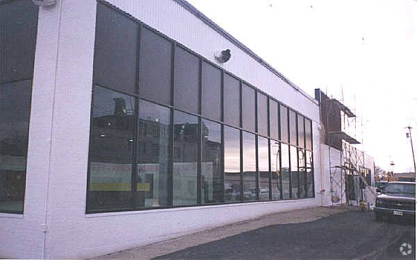
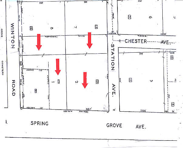
Property Detail
4631 Spring Grove Ave
Cincinnati, OH-KY-IN
NEC WINTON & SPRING GROVE87.52 X 150 IRR PT LOT 1 EVANS PLAT A EST
219-0055-0015
Hamilton
Storebuilding
Ohio
MG
1
2025
2.22 AC
2025
Forest Park/West
008000
Cincinnati/Dayton
28,280 SF
NEARBY LISTINGS FOR SALE OR LEASE
DEMOGRAPHICS near 4631 Spring Grove Ave
1 mile
3 mile
5 mile
2025 Total Population
5,397
117,979
347,949
2030 Population
5,440
120,590
354,471
Pop Growth 2025-2030
+ 0.80%
+ 2.21%
+ 1.87%
Average Age
40
35
37
2025 Total Households
2,461
48,730
152,259
HH Growth 2025-2030
+ 0.73%
+ 2.29%
+ 1.96%
Median Household Inc
$74,719
$42,959
$55,023
Avg Household Size
2.10
2.10
2.10
2025 Avg HH Vehicles
2.00
1.00
1.00
Median Home Value
$222,945
$225,909
$219,961
Median Year Built
1947
1951
1952
Nearby Places
Map Layers
Map Styles
 Street
 Aerial
Layers
 Traffic
 Biking
Places
Listings with unknown addresses are not visible on the map
- Restaurants
- Banks
- Shops
- Fitness
- Groceries
PUBLIC TRANSPORTATION
COMMUTER RAIL
Drive
Walk
Distance
12 min
6.1 mi
AIRPORT
Cincinnati/Northern Kentucky International
Drive
Walk
Distance
Cincinnati/Northern Kentucky International
36 min
20.2 mi
Nearby Properties
Address
Land Use
TOTAL SIZE
Lot Size
Zoning
Address
Land Use
TOTAL SIZE
Lot Size
Zoning
77.73 AC
IR
Address
Land Use
TOTAL SIZE
Lot Size
Zoning
6.35 AC
IR
Address
Land Use
TOTAL SIZE
Lot Size
Zoning
62.10 AC
Address
Land Use
TOTAL SIZE
Lot Size
Zoning
22.45 AC
Address
Land Use
TOTAL SIZE
Lot Size
Zoning
3.09 AC
Address
Land Use
TOTAL SIZE
Lot Size
Zoning
2.80 AC
IR
Address
Land Use
TOTAL SIZE
Lot Size
Zoning
3.40 AC
IR
Address
Land Use
TOTAL SIZE
Lot Size
Zoning
Address
Land Use
TOTAL SIZE
Lot Size
Zoning
Address
Land Use
TOTAL SIZE
Lot Size
Zoning
7.14 AC
Address
Land Use
TOTAL SIZE
Lot Size
Zoning
26.16 AC
Address
Land Use
TOTAL SIZE
Lot Size
Zoning
13.32 AC
Address
Land Use
TOTAL SIZE
Lot Size
Zoning
16.67 AC
IR
Address
Land Use
TOTAL SIZE
Lot Size
Zoning
3,184 SF
2.34 AC
IR
Address
Land Use
TOTAL SIZE
Lot Size
Zoning
Address
Land Use
TOTAL SIZE
Lot Size
Zoning
2.97 AC
IR
Address
Land Use
TOTAL SIZE
Lot Size
Zoning
112.35 AC
RM20
Address
Land Use
TOTAL SIZE
Lot Size
Zoning
29.60 AC
IR
Address
Land Use
TOTAL SIZE
Lot Size
Zoning
11.36 AC
IR
Address
Land Use
TOTAL SIZE
Lot Size
Zoning
0.37 AC
IR
Address
Land Use
TOTAL SIZE
Lot Size
Zoning
Address
Land Use
TOTAL SIZE
Lot Size
Zoning
2,916 SF
27.68 AC
Address
Land Use
TOTAL SIZE
Lot Size
Zoning
Address
Land Use
TOTAL SIZE
Lot Size
Zoning
10,778 SF
0.09 AC
CCM
Address
Land Use
TOTAL SIZE
Lot Size
Zoning
3.34 AC
Address
Land Use
TOTAL SIZE
Lot Size
Zoning
1.88 AC
Address
Land Use
TOTAL SIZE
Lot Size
Zoning
1.57 AC
Address
Land Use
TOTAL SIZE
Lot Size
Zoning
6.34 AC
Address
Land Use
TOTAL SIZE
Lot Size
Zoning
1,020 SF
44.83 AC
PR
Address
Land Use
TOTAL SIZE
Lot Size
Zoning
The World's #1 Commercial Real Estate Marketplace
Connect with us
© 2026 CoStar Group
The information above has been obtained from sources believed reliable. While we do not doubt its accuracy we have not verified it and make no guarantee, warranty or representation about it. It is your responsibility to independently confirm its accuracy and completeness. Any projections, opinions, assumptions, or estimates used are for example only and do not represent the current or future performance of the property. The value of this transaction to you depends on tax and other factors which should be evaluated by your tax, financial, and legal advisors. You and your advisors should conduct a careful, independent investigation of the property to determine to your satisfaction the suitability of the property for your needs.