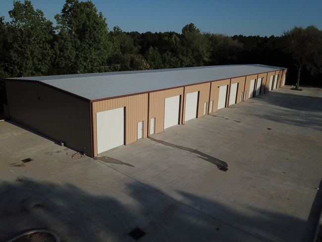
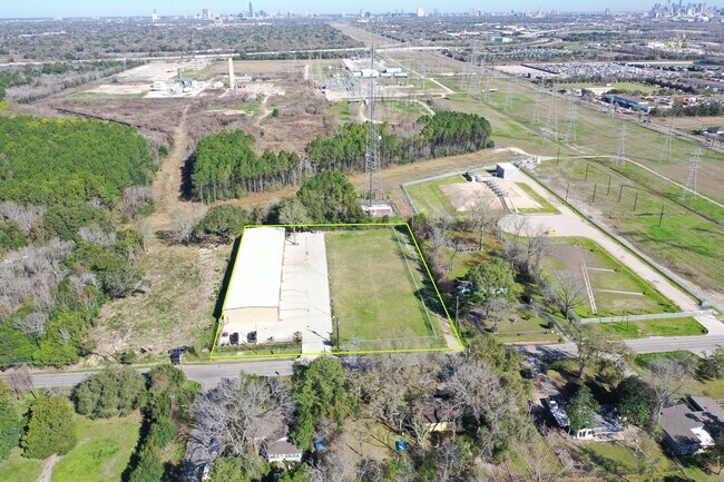
Property Record
4632 Allum Rd, Houston, TX 77045

NEARBY LISTINGS FOR SALE OR LEASE
Property Detail
4632 Allum Rd
Houston-The Woodlands-Sugar Land, TX
Allum Acre Home
0642420010035
LT 35 BLK 1 ALLUM ACRE HOME
Autorepair
Harris
X
Texas
48201C0865M
35
2024
1 AC
2025
Southwest Far
330200
Houston
15,000 SF
DEMOGRAPHICS near 4632 Allum Rd
1 Mile
3 Mile
5 Mile
2024 Total Population
10,126
107,554
335,802
2029 Population
10,532
109,815
350,840
Pop Growth 2024-2029
+ 4.01%
+ 2.10%
+ 4.48%
Average Age
38
37
37
2024 Total Households
3,203
37,780
124,762
HH Growth 2024-2029
+ 3.84%
+ 2.11%
+ 4.28%
Median Household Inc
$68,282
$65,206
$58,910
Avg Household Size
3.00
2.80
2.60
2024 Avg HH Vehicles
2.00
2.00
2.00
Median Home Value
$147,740
$197,118
$231,832
Median Year Built
1981
1976
1981
Nearby Places
Map Layers
Map Styles
 Street
 Aerial
- Restaurants
- Banks
- Shops
- Fitness
- Groceries
PUBLIC TRANSPORTATION
AIRPORT
William P Hobby
DRIVE
WALK
Distance
William P Hobby
26 min
12.8 mi
George Bush Intcntl/Houston
DRIVE
WALK
Distance
George Bush Intcntl/Houston
42 min
29.0 mi
Freight Ports
Port of Houston
DRIVE
WALK
Distance
Port of Houston
26 min
16.5 mi
SALE & LEASE HISTORY
LISTING DATE
SALE/LEASE

Jan 11, 2019
For Sale
Feb 12, 2020
For Sale
Apr 25, 2018
For Lease
Nearby Properties
Address
Land Use
TOTAL SIZE
Lot Size
Zoning
Address
Land Use
TOTAL SIZE
Lot Size
Zoning
1,139,160 SF
75.11 AC
Address
Land Use
TOTAL SIZE
Lot Size
Zoning
15.46 AC
Address
Land Use
TOTAL SIZE
Lot Size
Zoning
354,377 SF
8.10 AC
Address
Land Use
TOTAL SIZE
Lot Size
Zoning
28.22 AC
Address
Land Use
TOTAL SIZE
Lot Size
Zoning
305,512 SF
13.74 AC
Address
Land Use
TOTAL SIZE
Lot Size
Zoning
640,860 SF
5.31 AC
Address
Land Use
TOTAL SIZE
Lot Size
Zoning
429,368 SF
27.94 AC
Address
Land Use
TOTAL SIZE
Lot Size
Zoning
297,620 SF
11.01 AC
Address
Land Use
TOTAL SIZE
Lot Size
Zoning
292,644 SF
15.47 AC
Address
Land Use
TOTAL SIZE
Lot Size
Zoning
261,824 SF
10 AC
Address
Land Use
TOTAL SIZE
Lot Size
Zoning
432,938 SF
4.31 AC
Address
Land Use
TOTAL SIZE
Lot Size
Zoning
534,800 SF
33.43 AC
Address
Land Use
TOTAL SIZE
Lot Size
Zoning
290,624 SF
3.17 AC
Address
Land Use
TOTAL SIZE
Lot Size
Zoning
51.50 AC
Address
Land Use
TOTAL SIZE
Lot Size
Zoning
255,680 SF
13.42 AC
Address
Land Use
TOTAL SIZE
Lot Size
Zoning
301,360 SF
11.97 AC
Address
Land Use
TOTAL SIZE
Lot Size
Zoning
242,982 SF
11.56 AC
Address
Land Use
TOTAL SIZE
Lot Size
Zoning
423,270 SF
32.95 AC
Address
Land Use
TOTAL SIZE
Lot Size
Zoning
363,134 SF
18.52 AC
Address
Land Use
TOTAL SIZE
Lot Size
Zoning
414,014 SF
7.77 AC
Address
Land Use
TOTAL SIZE
Lot Size
Zoning
253,163 SF
8.66 AC
Address
Land Use
TOTAL SIZE
Lot Size
Zoning
371,335 SF
31.65 AC
Address
Land Use
TOTAL SIZE
Lot Size
Zoning
186,759 SF
42.60 AC
Address
Land Use
TOTAL SIZE
Lot Size
Zoning
143,100 SF
9.77 AC
Address
Land Use
TOTAL SIZE
Lot Size
Zoning
240,000 SF
12.45 AC
Address
Land Use
TOTAL SIZE
Lot Size
Zoning
310,527 SF
11.48 AC
Address
Land Use
TOTAL SIZE
Lot Size
Zoning
116,350 SF
7.81 AC
Address
Land Use
TOTAL SIZE
Lot Size
Zoning
209,728 SF
11.93 AC
Address
Land Use
TOTAL SIZE
Lot Size
Zoning
191,931 SF
8.25 AC
Address
Land Use
TOTAL SIZE
Lot Size
Zoning
411,605 SF
19.51 AC
The World's #1 Commercial Real Estate Marketplace
Connect with us
© 2026 CoStar Group
The information above has been obtained from sources believed reliable. While we do not doubt its accuracy we have not verified it and make no guarantee, warranty or representation about it. It is your responsibility to independently confirm its accuracy and completeness. Any projections, opinions, assumptions, or estimates used are for example only and do not represent the current or future performance of the property. The value of this transaction to you depends on tax and other factors which should be evaluated by your tax, financial, and legal advisors. You and your advisors should conduct a careful, independent investigation of the property to determine to your satisfaction the suitability of the property for your needs.