Property Record
4406 Snapfinger Woods Dr, Decatur, GA 30035
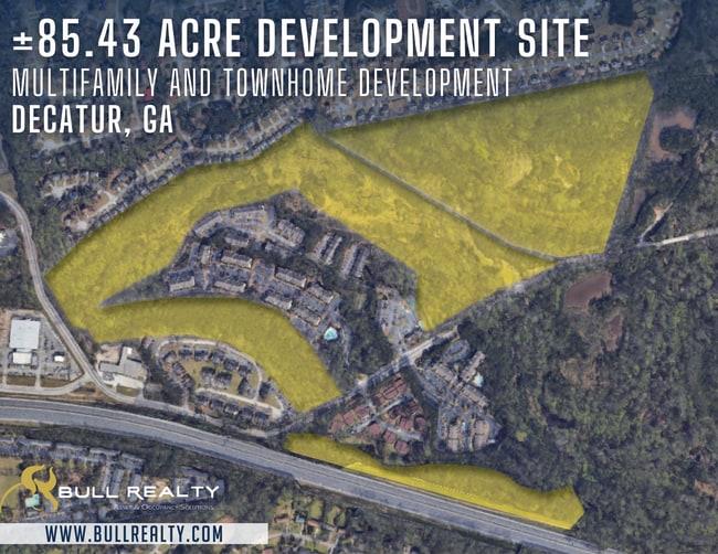
This Property Is For Sale
NEARBY LISTINGS FOR SALE OR LEASE
Property Detail
4406 Snapfinger Woods Dr
Atlanta-Sandy Springs-Roswell, GA
234 X 503 X 46 X 89 X 245 X 489 X 37 X 110 2.32AC
15-127-02-005
DeKalb
Commercialacreage
Georgia
AE
28
13089C0154J
33.34 AC
2025
I-20 East/Conyers
2025
Atlanta
023213
DEMOGRAPHICS near 4406 Snapfinger Woods Dr
1 Mile
3 Mile
5 Mile
2024 Total Population
7,635
80,597
180,995
2029 Population
7,431
79,563
179,463
Pop Growth 2024-2029
(2.67%)
(1.28%)
(0.85%)
Average Age
36
39
40
2024 Total Households
3,066
30,108
66,862
HH Growth 2024-2029
(2.84%)
(1.45%)
(0.96%)
Median Household Inc
$58,922
$60,724
$60,774
Avg Household Size
2.50
2.60
2.60
2024 Avg HH Vehicles
1.00
2.00
2.00
Median Home Value
$192,374
$177,844
$191,771
Median Year Built
1995
1989
1986
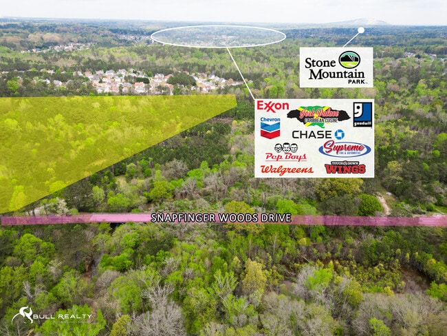
Nearby Places
Map Layers
Map Styles
 Street
 Aerial
- Restaurants
- Banks
- Shops
- Fitness
- Groceries
PUBLIC TRANSPORTATION
AIRPORT
Hartsfield - Jackson Atlanta International
DRIVE
WALK
Distance
Hartsfield - Jackson Atlanta International
27 min
16.5 mi
Freight Ports
Georgia Ports - Savannah
DRIVE
WALK
Distance
Georgia Ports - Savannah
280 min
248.4 mi
Nearby Properties
Address
Land Use
TOTAL SIZE
Lot Size
Zoning
Address
Land Use
TOTAL SIZE
Lot Size
Zoning
988,394 SF
102.84 AC
RM100
Address
Land Use
TOTAL SIZE
Lot Size
Zoning
834,629 SF
59.49 AC
RM100
Address
Land Use
TOTAL SIZE
Lot Size
Zoning
317,008 SF
37.05 AC
RM100
Address
Land Use
TOTAL SIZE
Lot Size
Zoning
484,198 SF
31.10 AC
RM100
Address
Land Use
TOTAL SIZE
Lot Size
Zoning
250,496 SF
14.35 AC
OI
Address
Land Use
TOTAL SIZE
Lot Size
Zoning
284,650 SF
21.75 AC
R100
Address
Land Use
TOTAL SIZE
Lot Size
Zoning
249,506 SF
21 AC
RM100
Address
Land Use
TOTAL SIZE
Lot Size
Zoning
71,208 SF
15 AC
X
Address
Land Use
TOTAL SIZE
Lot Size
Zoning
217,925 SF
23.69 AC
RM100
Address
Land Use
TOTAL SIZE
Lot Size
Zoning
292,395 SF
19.65 AC
RM100
Address
Land Use
TOTAL SIZE
Lot Size
Zoning
253,740 SF
13.33 AC
RM75
Address
Land Use
TOTAL SIZE
Lot Size
Zoning
158,939 SF
14.09 AC
RM85
Address
Land Use
TOTAL SIZE
Lot Size
Zoning
256,445 SF
11.71 AC
RM85
Address
Land Use
TOTAL SIZE
Lot Size
Zoning
209,022 SF
16.22 AC
RM100
Address
Land Use
TOTAL SIZE
Lot Size
Zoning
814,943 SF
40.83 AC
M
Address
Land Use
TOTAL SIZE
Lot Size
Zoning
249,668 SF
16.76 AC
RM100
Address
Land Use
TOTAL SIZE
Lot Size
Zoning
221,594 SF
15.90 AC
RM85
Address
Land Use
TOTAL SIZE
Lot Size
Zoning
174,027 SF
35.37 AC
R100
Address
Land Use
TOTAL SIZE
Lot Size
Zoning
23,072 SF
5.48 AC
C1
Address
Land Use
TOTAL SIZE
Lot Size
Zoning
300,697 SF
21.18 AC
RM85
Address
Land Use
TOTAL SIZE
Lot Size
Zoning
208,711 SF
34.59 AC
X
Address
Land Use
TOTAL SIZE
Lot Size
Zoning
277,816 SF
18.15 AC
RM100
Address
Land Use
TOTAL SIZE
Lot Size
Zoning
217,904 SF
14.84 AC
Address
Land Use
TOTAL SIZE
Lot Size
Zoning
182,490 SF
12.46 AC
RM100
Address
Land Use
TOTAL SIZE
Lot Size
Zoning
168,610 SF
19 AC
M
Address
Land Use
TOTAL SIZE
Lot Size
Zoning
372,399 SF
12.63 AC
M
Address
Land Use
TOTAL SIZE
Lot Size
Zoning
83,910 SF
10.90 AC
RCH
Address
Land Use
TOTAL SIZE
Lot Size
Zoning
144,950 SF
8.96 AC
RM100
Address
Land Use
TOTAL SIZE
Lot Size
Zoning
137,574 SF
10.40 AC
RM100
Address
Land Use
TOTAL SIZE
Lot Size
Zoning
155,447 SF
14.33 AC
X
The World's #1 Commercial Real Estate Marketplace
Connect with us
© 2026 CoStar Group
The information above has been obtained from sources believed reliable. While we do not doubt its accuracy we have not verified it and make no guarantee, warranty or representation about it. It is your responsibility to independently confirm its accuracy and completeness. Any projections, opinions, assumptions, or estimates used are for example only and do not represent the current or future performance of the property. The value of this transaction to you depends on tax and other factors which should be evaluated by your tax, financial, and legal advisors. You and your advisors should conduct a careful, independent investigation of the property to determine to your satisfaction the suitability of the property for your needs.