Property Record
463651 State Road 200, Yulee, FL 32097

Property Detail
463651 State Road 200
37-2N-27-0000-0001-0280
PT JOHN LOW MILL GRANT SEC 37-2N-27E IN OR 2376/820 UTIL ESMT IN OR 2301/1581 ESMT OR 2307/1722
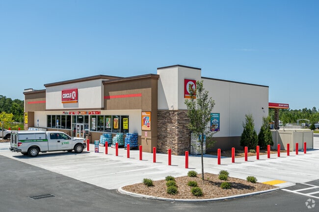
Storebuilding
NASSAU
IW
Florida
B and X Area of moderate flood hazard, usually the area between the limits of the 100-year and 500-year floods.
1
2025
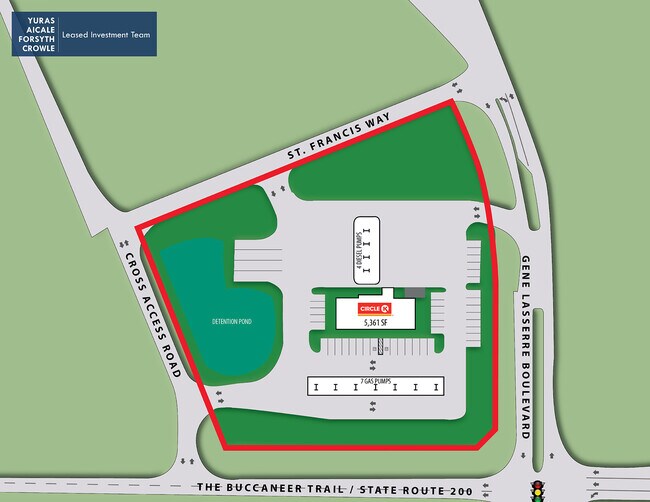
3.82 AC
2025
Nassau County
050306
Jacksonville (Florida)
5,382 SF
Jacksonville, FL
NEARBY LISTINGS FOR SALE OR LEASE
DEMOGRAPHICS near 463651 State Road 200
1 mile
3 mile
5 mile
2025 Total Population
1,701
21,134
39,542
2030 Population
1,903
23,614
44,501
Pop Growth 2025-2030
+ 11.88%
+ 11.73%
+ 12.54%
Average Age
44
43
42
2025 Total Households
699
8,260
15,008
HH Growth 2025-2030
+ 11.87%
+ 11.85%
+ 12.45%
Median Household Inc
$85,889
$90,903
$93,498
Avg Household Size
2.40
2.50
2.50
2025 Avg HH Vehicles
2.00
2.00
2.00
Median Home Value
$383,216
$386,520
$380,226
Median Year Built
2006
2007
2007
Nearby Places
Map Layers
Map Styles
 Street
 Aerial
Layers
 Traffic
 Biking
Places
Listings with unknown addresses are not visible on the map
- Restaurants
- Banks
- Shops
- Fitness
- Groceries
PUBLIC TRANSPORTATION
AIRPORT
Jacksonville International
Drive
Walk
Distance
Jacksonville International
28 min
16.1 mi
Freight Ports
Jacksonville Port
Drive
Walk
Distance
Jacksonville Port
38 min
27.6 mi
SALE & LEASE HISTORY
LISTING DATE
SALE/LEASE

Apr 20, 2020
For Sale
Nearby Properties
Address
Land Use
TOTAL SIZE
Lot Size
Zoning
Address
Land Use
TOTAL SIZE
Lot Size
Zoning
297,748 SF
92.23 AC
OR
Address
Land Use
TOTAL SIZE
Lot Size
Zoning
327,682 SF
24.09 AC
RG-2
Address
Land Use
TOTAL SIZE
Lot Size
Zoning
282,898 SF
22.88 AC
RG-2
Address
Land Use
TOTAL SIZE
Lot Size
Zoning
493,661 SF
49.08 AC
PUD
Address
Land Use
TOTAL SIZE
Lot Size
Zoning
112,634 SF
16 AC
GPU
Address
Land Use
TOTAL SIZE
Lot Size
Zoning
92,327 SF
22.06 AC
OR
Address
Land Use
TOTAL SIZE
Lot Size
Zoning
134,407 SF
2.77 AC
PUD
Address
Land Use
TOTAL SIZE
Lot Size
Zoning
63,363 SF
10.41 AC
PUD
Address
Land Use
TOTAL SIZE
Lot Size
Zoning
66,417 SF
8.75 AC
PUD
Address
Land Use
TOTAL SIZE
Lot Size
Zoning
163,686 SF
28.08 AC
CI
Address
Land Use
TOTAL SIZE
Lot Size
Zoning
59,703 SF
12.06 AC
GPU
Address
Land Use
TOTAL SIZE
Lot Size
Zoning
145,581 SF
3 AC
CG
Address
Land Use
TOTAL SIZE
Lot Size
Zoning
59,770 SF
8.51 AC
GPU
Address
Land Use
TOTAL SIZE
Lot Size
Zoning
48,863 SF
40.38 AC
RG-1
Address
Land Use
TOTAL SIZE
Lot Size
Zoning
125,733 SF
10.89 AC
IW
Address
Land Use
TOTAL SIZE
Lot Size
Zoning
109,094 SF
11.03 AC
IW
Address
Land Use
TOTAL SIZE
Lot Size
Zoning
44,933 SF
5.03 AC
PUD
Address
Land Use
TOTAL SIZE
Lot Size
Zoning
24.41 AC
IW
Address
Land Use
TOTAL SIZE
Lot Size
Zoning
44,734 SF
9.59 AC
OR
Address
Land Use
TOTAL SIZE
Lot Size
Zoning
89.52 AC
PD - ENCPA
Address
Land Use
TOTAL SIZE
Lot Size
Zoning
95,332 SF
23.03 AC
PUD
Address
Land Use
TOTAL SIZE
Lot Size
Zoning
35,296 SF
6.72 AC
PUD
Address
Land Use
TOTAL SIZE
Lot Size
Zoning
32,449 SF
7.57 AC
CI
Address
Land Use
TOTAL SIZE
Lot Size
Zoning
48,460 SF
14.60 AC
PUD
Address
Land Use
TOTAL SIZE
Lot Size
Zoning
83.12 AC
PD - ENCPA
Address
Land Use
TOTAL SIZE
Lot Size
Zoning
18,750 SF
4.58 AC
CI
Address
Land Use
TOTAL SIZE
Lot Size
Zoning
50,286 SF
4.39 AC
PUD
Address
Land Use
TOTAL SIZE
Lot Size
Zoning
35,463 SF
9.08 AC
PUD
Address
Land Use
TOTAL SIZE
Lot Size
Zoning
33,818 SF
2.88 AC
CI
Address
Land Use
TOTAL SIZE
Lot Size
Zoning
12,927 SF
8.03 AC
OR
The World's #1 Commercial Real Estate Marketplace
Connect with us
© 2026 CoStar Group
The information above has been obtained from sources believed reliable. While we do not doubt its accuracy we have not verified it and make no guarantee, warranty or representation about it. It is your responsibility to independently confirm its accuracy and completeness. Any projections, opinions, assumptions, or estimates used are for example only and do not represent the current or future performance of the property. The value of this transaction to you depends on tax and other factors which should be evaluated by your tax, financial, and legal advisors. You and your advisors should conduct a careful, independent investigation of the property to determine to your satisfaction the suitability of the property for your needs.