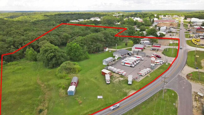
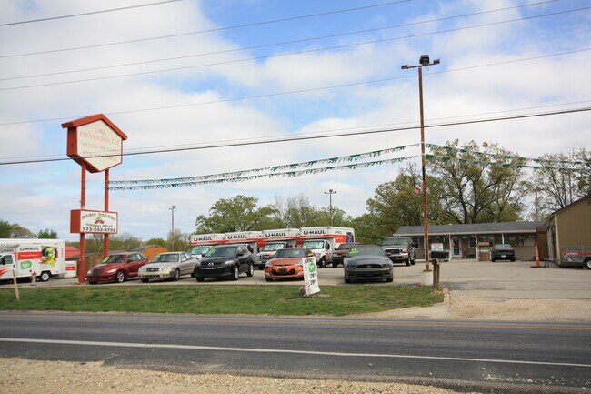
Property Record
464 Highway 42, Kaiser, MO 65047
NEARBY LISTINGS FOR SALE OR LEASE
Property Detail
464 Highway 42
Other Market Areas
Patoma Sub
143052000000024004
LOT 2 PATOMA SUB
Commercialacreage
Miller
X
Missouri
29029C0140C
2
2025
0.80 AC
2025
Missouri South Central Area
962801
DEMOGRAPHICS near 464 Highway 42
1 Mile
3 Mile
5 Mile
2024 Total Population
386
3,746
7,837
2029 Population
403
3,915
8,269
Pop Growth 2024-2029
+ 4.40%
+ 4.51%
+ 5.51%
Average Age
44
42
44
2024 Total Households
165
1,679
3,511
HH Growth 2024-2029
+ 4.24%
+ 4.05%
+ 5.07%
Median Household Inc
$47,500
$50,175
$53,651
Avg Household Size
2.20
2.10
2.10
2024 Avg HH Vehicles
2.00
2.00
2.00
Median Home Value
$130,303
$228,057
$249,700
Median Year Built
1990
1986
1986
Nearby Places
Map Layers
Map Styles
 Street
 Aerial
- Restaurants
- Banks
- Shops
- Fitness
- Groceries
SALE & LEASE HISTORY
LISTING DATE
SALE/LEASE

Jul 31, 2020
For Sale
Nearby Properties
Address
Land Use
TOTAL SIZE
Lot Size
Zoning
Address
Land Use
TOTAL SIZE
Lot Size
Zoning
Address
Land Use
TOTAL SIZE
Lot Size
Zoning
160,640 SF
19.90 AC
Address
Land Use
TOTAL SIZE
Lot Size
Zoning
38,951 SF
49.30 AC
Address
Land Use
TOTAL SIZE
Lot Size
Zoning
140,240 SF
9.10 AC
Address
Land Use
TOTAL SIZE
Lot Size
Zoning
124,432 SF
8.50 AC
Address
Land Use
TOTAL SIZE
Lot Size
Zoning
16,849 SF
26.40 AC
Address
Land Use
TOTAL SIZE
Lot Size
Zoning
49,740 SF
4.90 AC
Address
Land Use
TOTAL SIZE
Lot Size
Zoning
Address
Land Use
TOTAL SIZE
Lot Size
Zoning
84,646 SF
6.60 AC
Address
Land Use
TOTAL SIZE
Lot Size
Zoning
22,248 SF
2.39 AC
Address
Land Use
TOTAL SIZE
Lot Size
Zoning
17,234 SF
2.20 AC
Address
Land Use
TOTAL SIZE
Lot Size
Zoning
10,253 SF
9.20 AC
Address
Land Use
TOTAL SIZE
Lot Size
Zoning
55,350 SF
3.60 AC
Address
Land Use
TOTAL SIZE
Lot Size
Zoning
98,642 SF
16.20 AC
Address
Land Use
TOTAL SIZE
Lot Size
Zoning
33,990 SF
3.60 AC
Address
Land Use
TOTAL SIZE
Lot Size
Zoning
11,893 SF
1 AC
Address
Land Use
TOTAL SIZE
Lot Size
Zoning
11.23 AC
Address
Land Use
TOTAL SIZE
Lot Size
Zoning
53,429 SF
5.10 AC
Address
Land Use
TOTAL SIZE
Lot Size
Zoning
Address
Land Use
TOTAL SIZE
Lot Size
Zoning
19,314 SF
1.80 AC
Address
Land Use
TOTAL SIZE
Lot Size
Zoning
30,378 SF
1 AC
Address
Land Use
TOTAL SIZE
Lot Size
Zoning
26,776 SF
1.27 AC
Address
Land Use
TOTAL SIZE
Lot Size
Zoning
0.50 AC
Address
Land Use
TOTAL SIZE
Lot Size
Zoning
24,346 SF
19.51 AC
Address
Land Use
TOTAL SIZE
Lot Size
Zoning
19,099 SF
3.20 AC
Address
Land Use
TOTAL SIZE
Lot Size
Zoning
1,540 SF
13.20 AC
Address
Land Use
TOTAL SIZE
Lot Size
Zoning
14,820 SF
1.90 AC
Address
Land Use
TOTAL SIZE
Lot Size
Zoning
14,890 SF
2 AC
The World's #1 Commercial Real Estate Marketplace
Connect with us
© 2025 CoStar Group
The information above has been obtained from sources believed reliable. While we do not doubt its accuracy we have not verified it and make no guarantee, warranty or representation about it. It is your responsibility to independently confirm its accuracy and completeness. Any projections, opinions, assumptions, or estimates used are for example only and do not represent the current or future performance of the property. The value of this transaction to you depends on tax and other factors which should be evaluated by your tax, financial, and legal advisors. You and your advisors should conduct a careful, independent investigation of the property to determine to your satisfaction the suitability of the property for your needs.