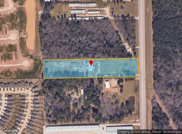
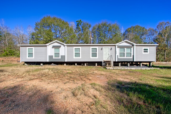
Property Record
464 Mccaleb Rd, Montgomery, TX 77316

NEARBY LISTINGS FOR SALE OR LEASE
Property Detail
464 Mccaleb Rd
0037-00-01630
Smith James
Commercialnec
A0037 - SMITH JAMES, TRACT 16-D, ACRES 5
X
Montgomery
48339C0375G
Texas
2024
5 AC
2025
Outlying Montgomery Cnty
694402
Houston
5,300 SF
Houston-Pasadena-The Woodlands, TX
DEMOGRAPHICS near 464 Mccaleb Rd
1 Mile
3 Mile
5 Mile
2024 Total Population
2,489
21,162
62,089
2029 Population
3,095
26,335
77,237
Pop Growth 2024-2029
+ 24.35%
+ 24.44%
+ 24.40%
Average Age
41
43
42
2024 Total Households
986
8,552
24,070
HH Growth 2024-2029
+ 24.44%
+ 24.47%
+ 24.50%
Median Household Inc
$72,499
$85,108
$97,434
Avg Household Size
2.50
2.50
2.60
2024 Avg HH Vehicles
2.00
2.00
2.00
Median Home Value
$242,996
$295,771
$335,942
Median Year Built
2003
1999
2006
Nearby Places
Map Layers
Map Styles
 Street
 Aerial
- Restaurants
- Banks
- Shops
- Fitness
- Groceries
PUBLIC TRANSPORTATION
AIRPORT
George Bush Intcntl/Houston
DRIVE
WALK
Distance
George Bush Intcntl/Houston
51 min
39.3 mi
Freight Ports
Port of Houston
DRIVE
WALK
Distance
Port of Houston
74 min
55.1 mi
SALE & LEASE HISTORY
LISTING DATE
SALE/LEASE

Mar 13, 2023
For Sale
Jan 16, 2025
For Sale
Nearby Properties
Address
Land Use
TOTAL SIZE
Lot Size
Zoning
Address
Land Use
TOTAL SIZE
Lot Size
Zoning
313,974 SF
25.03 AC
1
Address
Land Use
TOTAL SIZE
Lot Size
Zoning
203,934 SF
11.75 AC
Address
Land Use
TOTAL SIZE
Lot Size
Zoning
382,810 SF
18.58 AC
1
Address
Land Use
TOTAL SIZE
Lot Size
Zoning
114,101 SF
43.80 AC
Address
Land Use
TOTAL SIZE
Lot Size
Zoning
402,840 SF
26.73 AC
Address
Land Use
TOTAL SIZE
Lot Size
Zoning
69,122 SF
5.57 AC
Address
Land Use
TOTAL SIZE
Lot Size
Zoning
170,050 SF
10.80 AC
Address
Land Use
TOTAL SIZE
Lot Size
Zoning
47,530 SF
8.03 AC
3
Address
Land Use
TOTAL SIZE
Lot Size
Zoning
99,820 SF
4.51 AC
1
Address
Land Use
TOTAL SIZE
Lot Size
Zoning
74,395 SF
8.44 AC
Address
Land Use
TOTAL SIZE
Lot Size
Zoning
35,816 SF
251.16 AC
1
Address
Land Use
TOTAL SIZE
Lot Size
Zoning
94,100 SF
30.61 AC
Address
Land Use
TOTAL SIZE
Lot Size
Zoning
87,897 SF
6.69 AC
3
Address
Land Use
TOTAL SIZE
Lot Size
Zoning
54,511 SF
14.42 AC
1
Address
Land Use
TOTAL SIZE
Lot Size
Zoning
41,058 SF
35.94 AC
3
Address
Land Use
TOTAL SIZE
Lot Size
Zoning
18,630 SF
11.34 AC
1
Address
Land Use
TOTAL SIZE
Lot Size
Zoning
77,850 SF
6.11 AC
1
Address
Land Use
TOTAL SIZE
Lot Size
Zoning
39,210 SF
3.50 AC
Address
Land Use
TOTAL SIZE
Lot Size
Zoning
50,008 SF
8.86 AC
1
Address
Land Use
TOTAL SIZE
Lot Size
Zoning
125,615 SF
9.40 AC
Address
Land Use
TOTAL SIZE
Lot Size
Zoning
18,666 SF
10 AC
1
Address
Land Use
TOTAL SIZE
Lot Size
Zoning
24,376 SF
1.53 AC
Address
Land Use
TOTAL SIZE
Lot Size
Zoning
45,000 SF
6.59 AC
Address
Land Use
TOTAL SIZE
Lot Size
Zoning
48,000 SF
4.25 AC
Address
Land Use
TOTAL SIZE
Lot Size
Zoning
72,040 SF
5.50 AC
Address
Land Use
TOTAL SIZE
Lot Size
Zoning
17,271 SF
2.30 AC
3
Address
Land Use
TOTAL SIZE
Lot Size
Zoning
229,703 SF
13.42 AC
1
Address
Land Use
TOTAL SIZE
Lot Size
Zoning
51,320 SF
42.64 AC
1
Address
Land Use
TOTAL SIZE
Lot Size
Zoning
91,155 SF
7.15 AC
The World's #1 Commercial Real Estate Marketplace
Connect with us
© 2026 CoStar Group
The information above has been obtained from sources believed reliable. While we do not doubt its accuracy we have not verified it and make no guarantee, warranty or representation about it. It is your responsibility to independently confirm its accuracy and completeness. Any projections, opinions, assumptions, or estimates used are for example only and do not represent the current or future performance of the property. The value of this transaction to you depends on tax and other factors which should be evaluated by your tax, financial, and legal advisors. You and your advisors should conduct a careful, independent investigation of the property to determine to your satisfaction the suitability of the property for your needs.