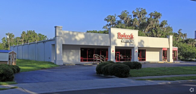
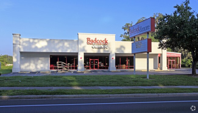
Property Record
464 S Duval Ave, Madison, FL 32340

NEARBY LISTINGS FOR SALE OR LEASE
Property Detail
464 S Duval Ave
27-1N-09-4212-001-000
Inglis Add
Storemultistory
BEG AT IP AT SE COR OF LOT 11 INGLIS ADD RUN E 147 TO POB THEN RUN N 278 NE 612 E 56 S 335 E 288 SLY 76 S 149 SWLY 536 S 90 W 43 TO POB OR 352/308 LESS .73 AC OR 448/65 ALSO .1 AC OR 448/63 ALSO .64 AC OR 469/234 OR 555/283 OR 685/355 LESS 2.451 AC O
X
Madison
12079C0285D
Florida
2025
11
2025
1.59 AC
110302
Florida Panhandle Area
18,284 SF
Other Market Areas
DEMOGRAPHICS near 464 S Duval Ave
1 Mile
3 Mile
5 Mile
2024 Total Population
4,474
7,439
8,697
2029 Population
4,569
7,569
8,832
Pop Growth 2024-2029
+ 2.12%
+ 1.75%
+ 1.55%
Average Age
42
42
43
2024 Total Households
1,586
2,611
3,113
HH Growth 2024-2029
+ 2.65%
+ 2.22%
+ 1.93%
Median Household Inc
$29,506
$31,033
$32,325
Avg Household Size
2.30
2.30
2.30
2024 Avg HH Vehicles
2.00
2.00
2.00
Median Home Value
$83,178
$92,675
$99,019
Median Year Built
1975
1978
1980
Nearby Places
Map Layers
Map Styles
 Street
 Aerial
- Restaurants
- Banks
- Shops
- Fitness
- Groceries
PUBLIC TRANSPORTATION
AIRPORT
Valdosta Regional
DRIVE
WALK
Distance
Valdosta Regional
36 min
25.4 mi
Freight Ports
Jacksonville Port
DRIVE
WALK
Distance
Jacksonville Port
132 min
115.5 mi
Nearby Properties
Address
Land Use
TOTAL SIZE
Lot Size
Zoning
Address
Land Use
TOTAL SIZE
Lot Size
Zoning
212,291 SF
59.16 AC
Address
Land Use
TOTAL SIZE
Lot Size
Zoning
228,223 SF
94.53 AC
INC
Address
Land Use
TOTAL SIZE
Lot Size
Zoning
78,953 SF
4.05 AC
INC
Address
Land Use
TOTAL SIZE
Lot Size
Zoning
136,374 SF
45.30 AC
PUB
Address
Land Use
TOTAL SIZE
Lot Size
Zoning
113,576 SF
8.92 AC
INC
Address
Land Use
TOTAL SIZE
Lot Size
Zoning
46,885 SF
4.84 AC
Address
Land Use
TOTAL SIZE
Lot Size
Zoning
40,872 SF
9.60 AC
Address
Land Use
TOTAL SIZE
Lot Size
Zoning
106,153 SF
10.22 AC
R2
Address
Land Use
TOTAL SIZE
Lot Size
Zoning
32,536 SF
2.03 AC
Address
Land Use
TOTAL SIZE
Lot Size
Zoning
27,283 SF
24.74 AC
Address
Land Use
TOTAL SIZE
Lot Size
Zoning
23,066 SF
5 AC
Address
Land Use
TOTAL SIZE
Lot Size
Zoning
57,806 SF
6.83 AC
INC
Address
Land Use
TOTAL SIZE
Lot Size
Zoning
13,486 SF
1.01 AC
INC
Address
Land Use
TOTAL SIZE
Lot Size
Zoning
11,432 SF
3.56 AC
Address
Land Use
TOTAL SIZE
Lot Size
Zoning
228.95 AC
Address
Land Use
TOTAL SIZE
Lot Size
Zoning
50,894 SF
5.74 AC
C5
Address
Land Use
TOTAL SIZE
Lot Size
Zoning
73,847 SF
4.60 AC
Address
Land Use
TOTAL SIZE
Lot Size
Zoning
64,621 SF
7.05 AC
Address
Land Use
TOTAL SIZE
Lot Size
Zoning
29,088 SF
0.68 AC
Address
Land Use
TOTAL SIZE
Lot Size
Zoning
10,918 SF
0.46 AC
Address
Land Use
TOTAL SIZE
Lot Size
Zoning
15,319 SF
6.50 AC
Address
Land Use
TOTAL SIZE
Lot Size
Zoning
22,384 SF
0.92 AC
Address
Land Use
TOTAL SIZE
Lot Size
Zoning
30,868 SF
7.77 AC
INC
Address
Land Use
TOTAL SIZE
Lot Size
Zoning
27,467 SF
4.17 AC
C1
Address
Land Use
TOTAL SIZE
Lot Size
Zoning
20,750 SF
7.38 AC
Address
Land Use
TOTAL SIZE
Lot Size
Zoning
11,055 SF
1.90 AC
INC
Address
Land Use
TOTAL SIZE
Lot Size
Zoning
10,390 SF
1.87 AC
Address
Land Use
TOTAL SIZE
Lot Size
Zoning
24,061 SF
8.36 AC
Address
Land Use
TOTAL SIZE
Lot Size
Zoning
10,049 SF
8.36 AC
Address
Land Use
TOTAL SIZE
Lot Size
Zoning
7,822 SF
20 AC
The World's #1 Commercial Real Estate Marketplace
Connect with us
© 2025 CoStar Group
The information above has been obtained from sources believed reliable. While we do not doubt its accuracy we have not verified it and make no guarantee, warranty or representation about it. It is your responsibility to independently confirm its accuracy and completeness. Any projections, opinions, assumptions, or estimates used are for example only and do not represent the current or future performance of the property. The value of this transaction to you depends on tax and other factors which should be evaluated by your tax, financial, and legal advisors. You and your advisors should conduct a careful, independent investigation of the property to determine to your satisfaction the suitability of the property for your needs.