Property Record
4640 N Henry Blvd, Stockbridge, GA 30281
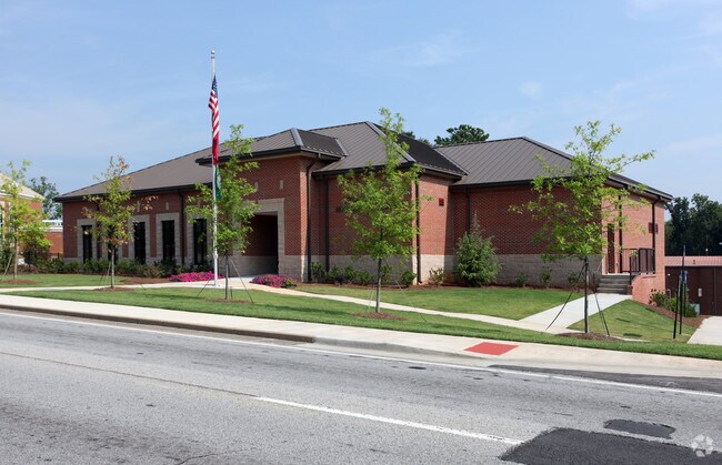


Property Detail
4640 N Henry Blvd
Atlanta-Sandy Springs-Roswell, GA
LAND LOT: 61 /LAND DISTRICT: 12; CITY OWNED
0S26-02-027-000
HENRY
Officebuilding
Georgia
B and X Area of moderate flood hazard, usually the area between the limits of the 100-year and 500-year floods.
61
2025
6.12 AC
2025
South Clayton/Henry Cnty
070113
Atlanta
45,169 SF
NEARBY LISTINGS FOR SALE OR LEASE
-
-
View all Stockbridge listings for sale on LoopNet.com
DEMOGRAPHICS near 4640 N Henry Blvd
1 mile
3 mile
5 mile
2025 Total Population
4,654
47,241
117,493
2030 Population
4,927
49,424
121,826
Pop Growth 2025-2030
+ 5.87%
+ 4.62%
+ 3.69%
Average Age
36
37
39
2025 Total Households
1,754
17,589
41,938
HH Growth 2025-2030
+ 6.04%
+ 4.64%
+ 3.72%
Median Household Inc
$52,541
$66,393
$72,856
Avg Household Size
2.60
2.60
2.70
2025 Avg HH Vehicles
2.00
2.00
2.00
Median Home Value
$202,273
$267,720
$290,916
Median Year Built
1991
1995
1995
Nearby Places
Map Layers
Map Styles
 Street
 Aerial
Layers
 Traffic
 Biking
Places
Listings with unknown addresses are not visible on the map
- Restaurants
- Banks
- Shops
- Fitness
- Groceries
PUBLIC TRANSPORTATION
AIRPORT
Hartsfield - Jackson Atlanta International
Drive
Walk
Distance
Hartsfield - Jackson Atlanta International
24 min
15.9 mi
Freight Ports
Georgia Ports - Savannah
Drive
Walk
Distance
Georgia Ports - Savannah
259 min
229.2 mi
Nearby Properties
Address
Land Use
TOTAL SIZE
Lot Size
Zoning
Address
Land Use
TOTAL SIZE
Lot Size
Zoning
368 SF
42.85 AC
RM
Address
Land Use
TOTAL SIZE
Lot Size
Zoning
22,400 SF
45.37 AC
RM
Address
Land Use
TOTAL SIZE
Lot Size
Zoning
35,082 SF
31.82 AC
C3
Address
Land Use
TOTAL SIZE
Lot Size
Zoning
476,716 SF
28.93 AC
C2
Address
Land Use
TOTAL SIZE
Lot Size
Zoning
4,010 SF
37.60 AC
C2
Address
Land Use
TOTAL SIZE
Lot Size
Zoning
17,862 SF
30 AC
PD
Address
Land Use
TOTAL SIZE
Lot Size
Zoning
19,140 SF
40.11 AC
RM
Address
Land Use
TOTAL SIZE
Lot Size
Zoning
21,678 SF
26.44 AC
RM
Address
Land Use
TOTAL SIZE
Lot Size
Zoning
707,800 SF
27.81 AC
M1
Address
Land Use
TOTAL SIZE
Lot Size
Zoning
2,426 SF
19.79 AC
RM
Address
Land Use
TOTAL SIZE
Lot Size
Zoning
284 SF
29 AC
RM
Address
Land Use
TOTAL SIZE
Lot Size
Zoning
25,952 SF
28.88 AC
RM
Address
Land Use
TOTAL SIZE
Lot Size
Zoning
9,264 SF
26.63 AC
RM
Address
Land Use
TOTAL SIZE
Lot Size
Zoning
510,053 SF
39.93 AC
M1
Address
Land Use
TOTAL SIZE
Lot Size
Zoning
25,508 SF
26.03 AC
RM
Address
Land Use
TOTAL SIZE
Lot Size
Zoning
439,225 SF
19.81 AC
M1
Address
Land Use
TOTAL SIZE
Lot Size
Zoning
399,189 SF
29.60 AC
M1
Address
Land Use
TOTAL SIZE
Lot Size
Zoning
182 SF
19.46 AC
RM
Address
Land Use
TOTAL SIZE
Lot Size
Zoning
269,100 SF
30.64 AC
Address
Land Use
TOTAL SIZE
Lot Size
Zoning
74,395 SF
49.35 AC
PD
Address
Land Use
TOTAL SIZE
Lot Size
Zoning
216,361 SF
27.44 AC
C3
Address
Land Use
TOTAL SIZE
Lot Size
Zoning
158 SF
15.59 AC
RM
Address
Land Use
TOTAL SIZE
Lot Size
Zoning
1,638 SF
12.79 AC
RM
Address
Land Use
TOTAL SIZE
Lot Size
Zoning
391,708 SF
20.04 AC
C2
Address
Land Use
TOTAL SIZE
Lot Size
Zoning
127,735 SF
20.74 AC
M1
Address
Land Use
TOTAL SIZE
Lot Size
Zoning
26,018 SF
11.03 AC
GB
Address
Land Use
TOTAL SIZE
Lot Size
Zoning
62,142 SF
4.36 AC
C1
Address
Land Use
TOTAL SIZE
Lot Size
Zoning
8,590 SF
11.09 AC
R3
Address
Land Use
TOTAL SIZE
Lot Size
Zoning
14,862 SF
10.18 AC
GB
Address
Land Use
TOTAL SIZE
Lot Size
Zoning
466,048 SF
6.51 AC
RA
The World's #1 Commercial Real Estate Marketplace
Connect with us
© 2026 CoStar Group
The information above has been obtained from sources believed reliable. While we do not doubt its accuracy we have not verified it and make no guarantee, warranty or representation about it. It is your responsibility to independently confirm its accuracy and completeness. Any projections, opinions, assumptions, or estimates used are for example only and do not represent the current or future performance of the property. The value of this transaction to you depends on tax and other factors which should be evaluated by your tax, financial, and legal advisors. You and your advisors should conduct a careful, independent investigation of the property to determine to your satisfaction the suitability of the property for your needs.