Property Record
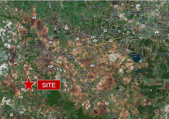
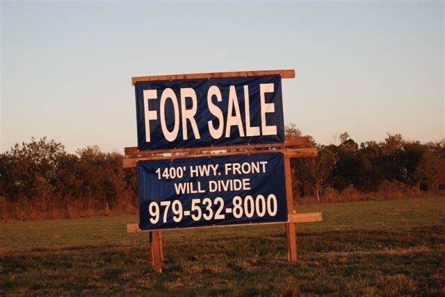
4643 Us 59 Hwy N, Hungerford, TX 77448

Property Detail
4643 Us 59 Hwy N
R34446
A20058 ABST.58 TRACT 75C
Commercialnec
WHARTON
B and X Area of moderate flood hazard, usually the area between the limits of the 100-year and 500-year floods.
Texas
2024
7.35 AC
2025
Texas South Area
740100
Other Market Areas
15,597 SF
El Campo, TX
NEARBY LISTINGS FOR SALE OR LEASE
DEMOGRAPHICS near 4643 Us 59 Hwy N
1 mile
3 mile
5 mile
2025 Total Population
76
833
5,297
2030 Population
74
842
5,357
Pop Growth 2025-2030
(2.63%)
+ 1.08%
+ 1.13%
Average Age
44
44
41
2025 Total Households
28
304
2,062
HH Growth 2025-2030
(3.57%)
+ 0.99%
+ 1.16%
Median Household Inc
$65,357
$63,375
$62,112
Avg Household Size
2.60
2.60
2.50
2025 Avg HH Vehicles
2.00
2.00
2.00
Median Home Value
$225,000
$187,499
$168,137
Median Year Built
1996
1985
1978
Nearby Places
Map Layers
Map Styles
 Street
 Aerial
Transit
 Traffic
 Biking
Places
Listings with unknown addresses are not visible on the map
- Restaurants
- Banks
- Shops
- Fitness
- Groceries
SALE & LEASE HISTORY
LISTING DATE
SALE/LEASE

Sep 13, 2017
For Sale
Jun 19, 2017
For Sale
Jul 21, 2017
For Lease
Apr 04, 2017
For Sale
Nearby Properties
Address
Land Use
TOTAL SIZE
Lot Size
Zoning
Address
Land Use
TOTAL SIZE
Lot Size
Zoning
Address
Land Use
TOTAL SIZE
Lot Size
Zoning
52,561 SF
13.24 AC
Address
Land Use
TOTAL SIZE
Lot Size
Zoning
38,018 SF
2.31 AC
Address
Land Use
TOTAL SIZE
Lot Size
Zoning
Address
Land Use
TOTAL SIZE
Lot Size
Zoning
7.03 AC
Address
Land Use
TOTAL SIZE
Lot Size
Zoning
9,040 SF
1.87 AC
Address
Land Use
TOTAL SIZE
Lot Size
Zoning
10,656 SF
1.90 AC
Address
Land Use
TOTAL SIZE
Lot Size
Zoning
Address
Land Use
TOTAL SIZE
Lot Size
Zoning
9,860 SF
1.29 AC
Address
Land Use
TOTAL SIZE
Lot Size
Zoning
72,234 SF
4.64 AC
Address
Land Use
TOTAL SIZE
Lot Size
Zoning
7,040 SF
9.39 AC
Address
Land Use
TOTAL SIZE
Lot Size
Zoning
5,363 SF
43 AC
Address
Land Use
TOTAL SIZE
Lot Size
Zoning
5,631 SF
36.22 AC
Address
Land Use
TOTAL SIZE
Lot Size
Zoning
14.41 AC
Address
Land Use
TOTAL SIZE
Lot Size
Zoning
4,941 SF
35.03 AC
Address
Land Use
TOTAL SIZE
Lot Size
Zoning
2,828 SF
17.03 AC
Address
Land Use
TOTAL SIZE
Lot Size
Zoning
4,008 SF
7.63 AC
Address
Land Use
TOTAL SIZE
Lot Size
Zoning
4,267 SF
4 AC
Address
Land Use
TOTAL SIZE
Lot Size
Zoning
4,464 SF
2.20 AC
Address
Land Use
TOTAL SIZE
Lot Size
Zoning
4,560 SF
77.12 AC
Address
Land Use
TOTAL SIZE
Lot Size
Zoning
5,189 SF
24.05 AC
Address
Land Use
TOTAL SIZE
Lot Size
Zoning
5,472 SF
1.10 AC
Address
Land Use
TOTAL SIZE
Lot Size
Zoning
5,343 SF
227.04 AC
Address
Land Use
TOTAL SIZE
Lot Size
Zoning
3,962 SF
11.52 AC
Address
Land Use
TOTAL SIZE
Lot Size
Zoning
23,150 SF
3.50 AC
Address
Land Use
TOTAL SIZE
Lot Size
Zoning
2,852 SF
10 AC
Address
Land Use
TOTAL SIZE
Lot Size
Zoning
3,705 SF
2 AC
Address
Land Use
TOTAL SIZE
Lot Size
Zoning
19,649 SF
0.59 AC
Address
Land Use
TOTAL SIZE
Lot Size
Zoning
2,293 SF
3.96 AC
The World's #1 Commercial Real Estate Marketplace
Connect with us
© 2026 CoStar Group
The information above has been obtained from sources believed reliable. While we do not doubt its accuracy we have not verified it and make no guarantee, warranty or representation about it. It is your responsibility to independently confirm its accuracy and completeness. Any projections, opinions, assumptions, or estimates used are for example only and do not represent the current or future performance of the property. The value of this transaction to you depends on tax and other factors which should be evaluated by your tax, financial, and legal advisors. You and your advisors should conduct a careful, independent investigation of the property to determine to your satisfaction the suitability of the property for your needs.