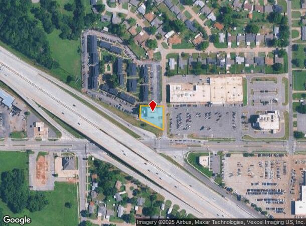
Property Record
4645 Tinker Diagonal, Oklahoma City, OK 73115
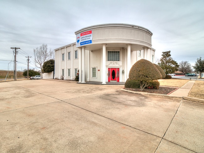

This Property Is For Sale
NEARBY LISTINGS FOR SALE OR LEASE
Property Detail
4645 Tinker Diagonal
Oklahoma City, OK
Del Crest Hts
153231175
DEL CREST HTS 000 000 BEG SE/C LOT 18 BLK 2 N150FT W136FT S86FT SELY TO BEG
Commercialnec
Oklahoma
X
Oklahoma
40109C0310H
18
2023
0.37 AC
2024
East Oklahoma County
107806
Oklahoma City
6,648 SF
DEMOGRAPHICS near 4645 Tinker Diagonal
1 Mile
3 Mile
5 Mile
2024 Total Population
8,466
68,536
140,960
2029 Population
8,645
70,850
145,851
Pop Growth 2024-2029
+ 2.11%
+ 3.38%
+ 3.47%
Average Age
39
36
37
2024 Total Households
3,526
27,429
56,576
HH Growth 2024-2029
+ 2.10%
+ 3.19%
+ 3.44%
Median Household Inc
$44,015
$47,825
$46,871
Avg Household Size
2.40
2.40
2.40
2024 Avg HH Vehicles
2.00
2.00
2.00
Median Home Value
$71,750
$106,307
$116,378
Median Year Built
1959
1969
1971
Nearby Places
Map Layers
Map Styles
 Street
 Aerial
- Restaurants
- Banks
- Shops
- Fitness
- Groceries
PUBLIC TRANSPORTATION
COMMUTER RAIL
Oklahoma City (Heartland Flyer - Amtrak)
DRIVE
WALK
Distance
Oklahoma City (Heartland Flyer - Amtrak)
8 min
5.5 mi
AIRPORT
Will Rogers World
DRIVE
WALK
Distance
Will Rogers World
26 min
15.0 mi
Freight Ports
Tulsa Port Of Catoosa
DRIVE
WALK
Distance
Tulsa Port Of Catoosa
134 min
123.7 mi
Nearby Properties
Address
Land Use
TOTAL SIZE
Lot Size
Zoning
Address
Land Use
TOTAL SIZE
Lot Size
Zoning
318,692 SF
15.25 AC
Address
Land Use
TOTAL SIZE
Lot Size
Zoning
142,772 SF
11.07 AC
Address
Land Use
TOTAL SIZE
Lot Size
Zoning
242,484 SF
13.18 AC
Address
Land Use
TOTAL SIZE
Lot Size
Zoning
392,100 SF
7.87 AC
I-2
Address
Land Use
TOTAL SIZE
Lot Size
Zoning
95,330 SF
25.68 AC
Address
Land Use
TOTAL SIZE
Lot Size
Zoning
431,366 SF
17.57 AC
Address
Land Use
TOTAL SIZE
Lot Size
Zoning
84,940 SF
9.58 AC
Address
Land Use
TOTAL SIZE
Lot Size
Zoning
119,916 SF
15.06 AC
I-3
Address
Land Use
TOTAL SIZE
Lot Size
Zoning
100,000 SF
11.18 AC
I-2
Address
Land Use
TOTAL SIZE
Lot Size
Zoning
203,263 SF
45.46 AC
Address
Land Use
TOTAL SIZE
Lot Size
Zoning
14,992 SF
1.34 AC
Address
Land Use
TOTAL SIZE
Lot Size
Zoning
124,997 SF
9.80 AC
Address
Land Use
TOTAL SIZE
Lot Size
Zoning
126,556 SF
6.74 AC
R-4
Address
Land Use
TOTAL SIZE
Lot Size
Zoning
145,328 SF
14.95 AC
R-4
Address
Land Use
TOTAL SIZE
Lot Size
Zoning
209,552 SF
11.67 AC
R-4
Address
Land Use
TOTAL SIZE
Lot Size
Zoning
35,245 SF
2.60 AC
Address
Land Use
TOTAL SIZE
Lot Size
Zoning
171,622 SF
9.74 AC
Address
Land Use
TOTAL SIZE
Lot Size
Zoning
8,811 SF
1.73 AC
Address
Land Use
TOTAL SIZE
Lot Size
Zoning
29,549 SF
89.39 AC
PUD
Address
Land Use
TOTAL SIZE
Lot Size
Zoning
109,637 SF
10.14 AC
I-2
Address
Land Use
TOTAL SIZE
Lot Size
Zoning
164,256 SF
8.38 AC
R-4
Address
Land Use
TOTAL SIZE
Lot Size
Zoning
94,261 SF
13.12 AC
Address
Land Use
TOTAL SIZE
Lot Size
Zoning
54,338 SF
10.24 AC
Address
Land Use
TOTAL SIZE
Lot Size
Zoning
141,254 SF
12.15 AC
Address
Land Use
TOTAL SIZE
Lot Size
Zoning
74,184 SF
3.43 AC
Address
Land Use
TOTAL SIZE
Lot Size
Zoning
53,001 SF
1.71 AC
I-1
Address
Land Use
TOTAL SIZE
Lot Size
Zoning
208,900 SF
10.15 AC
Address
Land Use
TOTAL SIZE
Lot Size
Zoning
100,092 SF
5.37 AC
Address
Land Use
TOTAL SIZE
Lot Size
Zoning
62,506 SF
5.97 AC
Address
Land Use
TOTAL SIZE
Lot Size
Zoning
47,040 SF
5.41 AC
The World's #1 Commercial Real Estate Marketplace
Connect with us
© 2025 CoStar Group
The information above has been obtained from sources believed reliable. While we do not doubt its accuracy we have not verified it and make no guarantee, warranty or representation about it. It is your responsibility to independently confirm its accuracy and completeness. Any projections, opinions, assumptions, or estimates used are for example only and do not represent the current or future performance of the property. The value of this transaction to you depends on tax and other factors which should be evaluated by your tax, financial, and legal advisors. You and your advisors should conduct a careful, independent investigation of the property to determine to your satisfaction the suitability of the property for your needs.