Property Record
4647 S 33Rd St, Phoenix, AZ 85040
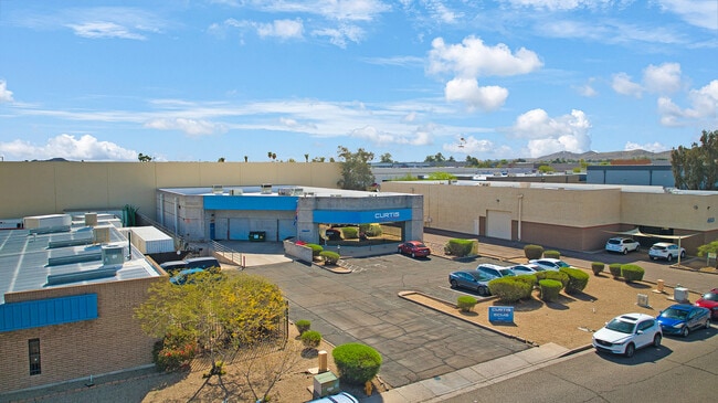

Property Detail
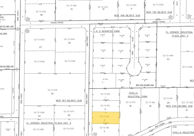
4647 S 33Rd St
122-72-064
CHOLLA INDUSTRIAL PARK MCR 234-38
Warehouse
MARICOPA
I-P
Arizona
C and X Area of minimal flood hazard, usually depicted on FIRMs as above the 500-year flood level.
3
2025
0.51 AC
2025
S Airport N of Roeser
116203
Phoenix
7,763 SF
Phoenix-Mesa-Chandler, AZ
NEARBY LISTINGS FOR SALE OR LEASE
DEMOGRAPHICS near 4647 S 33Rd St
1 mile
3 mile
5 mile
2025 Total Population
7,277
68,185
293,817
2030 Population
7,650
70,583
305,873
Pop Growth 2025-2030
+ 5.13%
+ 3.52%
+ 4.10%
Average Age
32
36
35
2025 Total Households
2,342
23,628
107,448
HH Growth 2025-2030
+ 5.38%
+ 3.63%
+ 4.36%
Median Household Inc
$69,317
$73,592
$67,618
Avg Household Size
3.00
2.80
2.50
2025 Avg HH Vehicles
2.00
2.00
2.00
Median Home Value
$360,286
$365,415
$392,130
Median Year Built
1988
1987
1984
Nearby Places
Map Layers
Map Styles
 Street
 Aerial
Layers
 Traffic
 Biking
Places
Listings with unknown addresses are not visible on the map
- Restaurants
- Banks
- Shops
- Fitness
- Groceries
PUBLIC TRANSPORTATION
AIRPORT
Phoenix Sky Harbor International
Drive
Walk
Distance
Phoenix Sky Harbor International
11 min
5.3 mi
Phoenix-Mesa Gateway
Drive
Walk
Distance
Phoenix-Mesa Gateway
37 min
27.3 mi
Freight Ports
Port of San Diego
Drive
Walk
Distance
Port of San Diego
403 min
368.6 mi
SALE & LEASE HISTORY
LISTING DATE
SALE/LEASE

Apr 22, 2025
For Sale
Nearby Properties
Address
Land Use
TOTAL SIZE
Lot Size
Zoning
Address
Land Use
TOTAL SIZE
Lot Size
Zoning
12.93 AC
I-P
Address
Land Use
TOTAL SIZE
Lot Size
Zoning
2,901,193 SF
20.73 AC
A-1
Address
Land Use
TOTAL SIZE
Lot Size
Zoning
1,949,842 SF
40 AC
I-1
Address
Land Use
TOTAL SIZE
Lot Size
Zoning
2,705,875 SF
133.42 AC
I-1
Address
Land Use
TOTAL SIZE
Lot Size
Zoning
81,816 SF
7.95 AC
Address
Land Use
TOTAL SIZE
Lot Size
Zoning
94,162 SF
9.40 AC
I-2
Address
Land Use
TOTAL SIZE
Lot Size
Zoning
1,479,006 SF
84.96 AC
C-R
Address
Land Use
TOTAL SIZE
Lot Size
Zoning
Address
Land Use
TOTAL SIZE
Lot Size
Zoning
10,776 SF
10.14 AC
C-C
Address
Land Use
TOTAL SIZE
Lot Size
Zoning
1,020,776 SF
11.33 AC
I-1
Address
Land Use
TOTAL SIZE
Lot Size
Zoning
331,050 SF
39 AC
I-1
Address
Land Use
TOTAL SIZE
Lot Size
Zoning
522,676 SF
264.16 AC
I-1
Address
Land Use
TOTAL SIZE
Lot Size
Zoning
32,968 SF
2.10 AC
I-P
Address
Land Use
TOTAL SIZE
Lot Size
Zoning
635,169 SF
92.76 AC
I-1
Address
Land Use
TOTAL SIZE
Lot Size
Zoning
9,344 SF
134.45 AC
R3
Address
Land Use
TOTAL SIZE
Lot Size
Zoning
746,457 SF
20.95 AC
I-1
Address
Land Use
TOTAL SIZE
Lot Size
Zoning
1,524,499 SF
159.88 AC
I-1
Address
Land Use
TOTAL SIZE
Lot Size
Zoning
13.72 AC
Address
Land Use
TOTAL SIZE
Lot Size
Zoning
469,025 SF
199.15 AC
A-1
Address
Land Use
TOTAL SIZE
Lot Size
Zoning
277,910 SF
53.82 AC
A-1
Address
Land Use
TOTAL SIZE
Lot Size
Zoning
359,401 SF
96.70 AC
R-6
Address
Land Use
TOTAL SIZE
Lot Size
Zoning
25,289 SF
2.70 AC
I-2
Address
Land Use
TOTAL SIZE
Lot Size
Zoning
252,306 SF
112.57 AC
A-2
Address
Land Use
TOTAL SIZE
Lot Size
Zoning
180,690 SF
11.20 AC
I-P
Address
Land Use
TOTAL SIZE
Lot Size
Zoning
351,199 SF
22.04 AC
I-1
Address
Land Use
TOTAL SIZE
Lot Size
Zoning
586,083 SF
69.82 AC
Address
Land Use
TOTAL SIZE
Lot Size
Zoning
494,504 SF
18.83 AC
I-1
Address
Land Use
TOTAL SIZE
Lot Size
Zoning
40 AC
I-1
Address
Land Use
TOTAL SIZE
Lot Size
Zoning
756,193 SF
23.40 AC
I-1
Address
Land Use
TOTAL SIZE
Lot Size
Zoning
309.82 AC
R-35
The World's #1 Commercial Real Estate Marketplace
Connect with us
© 2026 CoStar Group
The information above has been obtained from sources believed reliable. While we do not doubt its accuracy we have not verified it and make no guarantee, warranty or representation about it. It is your responsibility to independently confirm its accuracy and completeness. Any projections, opinions, assumptions, or estimates used are for example only and do not represent the current or future performance of the property. The value of this transaction to you depends on tax and other factors which should be evaluated by your tax, financial, and legal advisors. You and your advisors should conduct a careful, independent investigation of the property to determine to your satisfaction the suitability of the property for your needs.