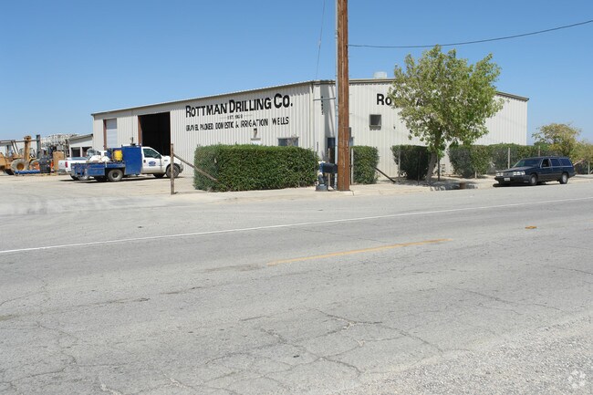
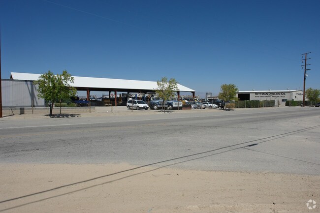
Property Record
46471 Division St, Lancaster, CA 93535


Property Detail
46471 Division St
3137-007-023
*S 1/2 (EX OF ST) OF E 20 ACS OF THAT POR OF LOT 1 LYING N OF A LINE PARALLEL WITH AND DIST N AT R/A 608 FT FROM S LINE OF SD LOT 1 IN NE 1/4 OF SEC 3 T 7N R 12W
Lightindustrial
Los Angeles
LRHI
California
C and X Area of minimal flood hazard, usually depicted on FIRMs as above the 500-year flood level.
1
2024
9.78 AC
2025
Antelope Valley
901300
Los Angeles
19,050 SF
Los Angeles-Long Beach-Glendale, CA
NEARBY LISTINGS FOR SALE OR LEASE
DEMOGRAPHICS near 46471 Division St
1 mile
3 mile
5 mile
2025 Total Population
312
52,491
136,118
2030 Population
317
52,244
136,473
Pop Growth 2025-2030
+ 1.60%
(0.47%)
+ 0.26%
Average Age
38
37
37
2025 Total Households
96
16,131
43,307
HH Growth 2025-2030
+ 1.04%
(0.53%)
+ 0.41%
Median Household Inc
$60,750
$58,617
$67,217
Avg Household Size
3.20
3.10
3.00
2025 Avg HH Vehicles
2.00
2.00
2.00
Median Home Value
$373,809
$322,294
$382,030
Median Year Built
1981
1979
1984
Nearby Places
Map Layers
Map Styles
 Street
 Aerial
Layers
 Traffic
 Biking
Places
Listings with unknown addresses are not visible on the map
- Restaurants
- Banks
- Shops
- Fitness
- Groceries
PUBLIC TRANSPORTATION
COMMUTER RAIL
Lancaster (Antelope Valley Line - Southern California Regional Rail Authority (Metrolink))
Drive
Walk
Distance
Lancaster (Antelope Valley Line - Southern California Regional Rail Authority (Metrolink))
5 min
2.6 mi
Freight Ports
Port of Long Beach
Drive
Walk
Distance
Port of Long Beach
115 min
98.1 mi
Nearby Properties
Address
Land Use
TOTAL SIZE
Lot Size
Zoning
Address
Land Use
TOTAL SIZE
Lot Size
Zoning
2,922,905 SF
85.01 AC
LRLI
Address
Land Use
TOTAL SIZE
Lot Size
Zoning
552,178 SF
17.77 AC
LRHI*
Address
Land Use
TOTAL SIZE
Lot Size
Zoning
145,593 SF
5.18 AC
LRC3*
Address
Land Use
TOTAL SIZE
Lot Size
Zoning
76,093 SF
1.37 AC
LRC3*
Address
Land Use
TOTAL SIZE
Lot Size
Zoning
73,248 SF
3.56 AC
LRR325UDP*
Address
Land Use
TOTAL SIZE
Lot Size
Zoning
70,456 SF
3.05 AC
LRRC
Address
Land Use
TOTAL SIZE
Lot Size
Zoning
51,233 SF
3.22 AC
LRC3*
Address
Land Use
TOTAL SIZE
Lot Size
Zoning
71,300 SF
5.25 AC
LRMDRZ*
Address
Land Use
TOTAL SIZE
Lot Size
Zoning
52,659 SF
2.16 AC
LRRC
Address
Land Use
TOTAL SIZE
Lot Size
Zoning
49,891 SF
1.62 AC
LRC3*
Address
Land Use
TOTAL SIZE
Lot Size
Zoning
113,960 SF
9 AC
LRD21*
Address
Land Use
TOTAL SIZE
Lot Size
Zoning
106,485 SF
1.09 AC
LRC3*
Address
Land Use
TOTAL SIZE
Lot Size
Zoning
52,478 SF
5.07 AC
LRCPD
Address
Land Use
TOTAL SIZE
Lot Size
Zoning
Address
Land Use
TOTAL SIZE
Lot Size
Zoning
41,162 SF
2.91 AC
LRC3-B1*
Address
Land Use
TOTAL SIZE
Lot Size
Zoning
83,194 SF
5.82 AC
LRSP80-03*
Address
Land Use
TOTAL SIZE
Lot Size
Zoning
59,384 SF
13.56 AC
LRHI*
Address
Land Use
TOTAL SIZE
Lot Size
Zoning
278,061 SF
7.01 AC
LRCPD*
Address
Land Use
TOTAL SIZE
Lot Size
Zoning
46,352 SF
9.46 AC
LRR7000*
Address
Land Use
TOTAL SIZE
Lot Size
Zoning
48,943 SF
2.99 AC
LRP*
Address
Land Use
TOTAL SIZE
Lot Size
Zoning
57,442 SF
3.11 AC
LRHDR
Address
Land Use
TOTAL SIZE
Lot Size
Zoning
110,636 SF
6.86 AC
LRD2
Address
Land Use
TOTAL SIZE
Lot Size
Zoning
100,856 SF
2.74 AC
LRC3*
Address
Land Use
TOTAL SIZE
Lot Size
Zoning
62,860 SF
2.68 AC
LRCPD*
Address
Land Use
TOTAL SIZE
Lot Size
Zoning
42,052 SF
0.56 AC
LRR2*
Address
Land Use
TOTAL SIZE
Lot Size
Zoning
552,178 SF
4.70 AC
LRHI
Address
Land Use
TOTAL SIZE
Lot Size
Zoning
27,070 SF
17.12 AC
LRHI
Address
Land Use
TOTAL SIZE
Lot Size
Zoning
57,050 SF
4.28 AC
LRLI
Address
Land Use
TOTAL SIZE
Lot Size
Zoning
15,126 SF
1.24 AC
LRC3*
The World's #1 Commercial Real Estate Marketplace
Connect with us
© 2026 CoStar Group
The information above has been obtained from sources believed reliable. While we do not doubt its accuracy we have not verified it and make no guarantee, warranty or representation about it. It is your responsibility to independently confirm its accuracy and completeness. Any projections, opinions, assumptions, or estimates used are for example only and do not represent the current or future performance of the property. The value of this transaction to you depends on tax and other factors which should be evaluated by your tax, financial, and legal advisors. You and your advisors should conduct a careful, independent investigation of the property to determine to your satisfaction the suitability of the property for your needs.