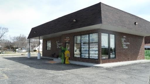
Property Record
465 E Roosevelt Rd, West Chicago, IL 60185


Property Detail
465 E Roosevelt Rd
04-15-301-001
WM KRONINGS PLAT OF SURVEY PRT LYG NWLY OF A LN DRAWN FROM A PT ON C/L DAYTON AVE 568.1 FT E OF INTERSECTION WITH C/L ROOSEVELT RD TO A PT ON C/L ROOSEVELT RD 506.54 FT SELY FROM SD INTERSECTION TRACT 1
Commercialnec
DuPage
C
Illinois
B and X Area of moderate flood hazard, usually the area between the limits of the 100-year and 500-year floods.
4
2024
0.53 AC
2024
Western East/West Corr
841503
Chicago
1,356 SF
Chicago-Naperville-Elgin, IL-IN
NEARBY LISTINGS FOR SALE OR LEASE
DEMOGRAPHICS near 465 E Roosevelt Rd
1 mile
3 mile
5 mile
2025 Total Population
7,849
40,814
122,321
2030 Population
7,828
40,725
123,071
Pop Growth 2025-2030
(0.27%)
(0.22%)
+ 0.61%
Average Age
36
40
41
2025 Total Households
2,148
13,590
43,432
HH Growth 2025-2030
(0.37%)
(0.35%)
+ 0.74%
Median Household Inc
$89,150
$99,060
$113,170
Avg Household Size
3.40
2.90
2.70
2025 Avg HH Vehicles
2.00
2.00
2.00
Median Home Value
$258,197
$292,775
$365,547
Median Year Built
1972
1976
1980
Nearby Places
Map Layers
Map Styles
 Street
 Aerial
Layers
 Traffic
 Biking
Places
Listings with unknown addresses are not visible on the map
- Restaurants
- Banks
- Shops
- Fitness
- Groceries
PUBLIC TRANSPORTATION
COMMUTER RAIL
West Chicago Station (Union Pacific West Line - Northeast Illinois Regional Commuter Railroad (Metra))
Drive
Walk
Distance
West Chicago Station (Union Pacific West Line - Northeast Illinois Regional Commuter Railroad (Metra))
4 min
1.8 mi
Winfield Station (Union Pacific West Line - Northeast Illinois Regional Commuter Railroad (Metra))
Drive
Walk
Distance
Winfield Station (Union Pacific West Line - Northeast Illinois Regional Commuter Railroad (Metra))
5 min
3.0 mi
AIRPORT
Chicago Midway International
Drive
Walk
Distance
Chicago Midway International
46 min
27.3 mi
Chicago O'Hare International
Drive
Walk
Distance
Chicago O'Hare International
45 min
27.4 mi
Freight Ports
Port Milwaukee
Drive
Walk
Distance
Port Milwaukee
125 min
99.9 mi
SALE & LEASE HISTORY
LISTING DATE
SALE/LEASE

Sep 23, 2016
For Sale
Nov 02, 2019
For Sale
Jul 15, 2021
For Sale
Nearby Properties
Address
Land Use
TOTAL SIZE
Lot Size
Zoning
Address
Land Use
TOTAL SIZE
Lot Size
Zoning
545,570 SF
22.66 AC
C
Address
Land Use
TOTAL SIZE
Lot Size
Zoning
38.68 AC
Address
Land Use
TOTAL SIZE
Lot Size
Zoning
42.27 AC
Address
Land Use
TOTAL SIZE
Lot Size
Zoning
26,302 SF
2.09 AC
C
Address
Land Use
TOTAL SIZE
Lot Size
Zoning
Address
Land Use
TOTAL SIZE
Lot Size
Zoning
26.41 AC
Address
Land Use
TOTAL SIZE
Lot Size
Zoning
28.84 AC
Address
Land Use
TOTAL SIZE
Lot Size
Zoning
277,018 SF
12.36 AC
I
Address
Land Use
TOTAL SIZE
Lot Size
Zoning
242,748 SF
11.65 AC
R
Address
Land Use
TOTAL SIZE
Lot Size
Zoning
13.15 AC
R
Address
Land Use
TOTAL SIZE
Lot Size
Zoning
39.42 AC
Address
Land Use
TOTAL SIZE
Lot Size
Zoning
16.68 AC
I
Address
Land Use
TOTAL SIZE
Lot Size
Zoning
168,302 SF
13.78 AC
I
Address
Land Use
TOTAL SIZE
Lot Size
Zoning
409,705 SF
16.21 AC
I
Address
Land Use
TOTAL SIZE
Lot Size
Zoning
1,808 SF
0.19 AC
C
Address
Land Use
TOTAL SIZE
Lot Size
Zoning
137,196 SF
8.82 AC
R
Address
Land Use
TOTAL SIZE
Lot Size
Zoning
80,180 SF
5.81 AC
R-4
Address
Land Use
TOTAL SIZE
Lot Size
Zoning
65,113 SF
2.77 AC
C
Address
Land Use
TOTAL SIZE
Lot Size
Zoning
181,420 SF
6.69 AC
I
Address
Land Use
TOTAL SIZE
Lot Size
Zoning
6.55 AC
C
Address
Land Use
TOTAL SIZE
Lot Size
Zoning
108,825 SF
23.42 AC
C
Address
Land Use
TOTAL SIZE
Lot Size
Zoning
14.09 AC
Address
Land Use
TOTAL SIZE
Lot Size
Zoning
153,965 SF
9.22 AC
I
Address
Land Use
TOTAL SIZE
Lot Size
Zoning
126,720 SF
5.84 AC
C
Address
Land Use
TOTAL SIZE
Lot Size
Zoning
64,384 SF
6.97 AC
C
Address
Land Use
TOTAL SIZE
Lot Size
Zoning
97,122 SF
4.42 AC
I
Address
Land Use
TOTAL SIZE
Lot Size
Zoning
159,960 SF
7.42 AC
C
Address
Land Use
TOTAL SIZE
Lot Size
Zoning
41,529 SF
7.73 AC
C
Address
Land Use
TOTAL SIZE
Lot Size
Zoning
137,661 SF
5.06 AC
I
Address
Land Use
TOTAL SIZE
Lot Size
Zoning
38,749 SF
6.75 AC
C
The World's #1 Commercial Real Estate Marketplace
Connect with us
© 2026 CoStar Group
The information above has been obtained from sources believed reliable. While we do not doubt its accuracy we have not verified it and make no guarantee, warranty or representation about it. It is your responsibility to independently confirm its accuracy and completeness. Any projections, opinions, assumptions, or estimates used are for example only and do not represent the current or future performance of the property. The value of this transaction to you depends on tax and other factors which should be evaluated by your tax, financial, and legal advisors. You and your advisors should conduct a careful, independent investigation of the property to determine to your satisfaction the suitability of the property for your needs.