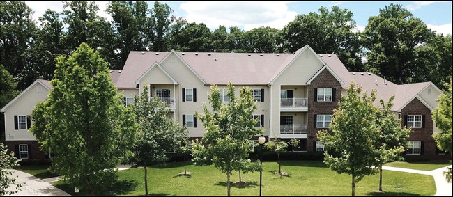
Property Record
465 Meadow Rd, Princeton, NJ 08540

NEARBY LISTINGS FOR SALE OR LEASE
Property Detail
465 Meadow Rd
Trenton, NJ
INCL BLK 8 LOTS 10-02 & 54
13-00008-0000-00010-02
Mercer
Apartment
New Jersey
X
10.2
34021C0141F
8.72 AC
2024
Princeton/Lawrenceville
2025
Northern New Jersey
004314
DEMOGRAPHICS near 465 Meadow Rd
1 Mile
3 Mile
5 Mile
2024 Total Population
6,528
37,109
102,340
2029 Population
6,539
36,981
101,598
Pop Growth 2024-2029
+ 0.17%
(0.34%)
(0.73%)
Average Age
34
38
41
2024 Total Households
2,536
12,964
38,321
HH Growth 2024-2029
+ 0.32%
(0.04%)
(0.69%)
Median Household Inc
$111,612
$152,906
$139,093
Avg Household Size
2.50
2.70
2.60
2024 Avg HH Vehicles
1.00
2.00
2.00
Median Home Value
$580,508
$696,420
$574,966
Median Year Built
2006
1987
1981
Nearby Places
Map Layers
Map Styles
 Street
 Aerial
- Restaurants
- Banks
- Shops
- Fitness
- Groceries
PUBLIC TRANSPORTATION
COMMUTER RAIL
Princeton (Princeton Branch - NJ Transit Commuter Rail (NJ Transit))
DRIVE
WALK
Distance
Princeton (Princeton Branch - NJ Transit Commuter Rail (NJ Transit))
8 min
3.5 mi
Princeton Junction (Northeast Corridor Line - NJ Transit Commuter Rail (NJ Transit), Princeton Branch - NJ Transit Commuter Rail (NJ Transit))
DRIVE
WALK
Distance
Princeton Junction (Northeast Corridor Line - NJ Transit Commuter Rail (NJ Transit), Princeton Branch - NJ Transit Commuter Rail (NJ Transit))
8 min
3.7 mi
AIRPORT
Trenton Mercer
DRIVE
WALK
Distance
Trenton Mercer
19 min
12.3 mi
Freight Ports
Port of Philadelphia
DRIVE
WALK
Distance
Port of Philadelphia
56 min
39.7 mi
Nearby Properties
Address
Land Use
TOTAL SIZE
Lot Size
Zoning
Address
Land Use
TOTAL SIZE
Lot Size
Zoning
272.88 AC
RD-1
Address
Land Use
TOTAL SIZE
Lot Size
Zoning
636,000 SF
60.76 AC
PHCR
Address
Land Use
TOTAL SIZE
Lot Size
Zoning
492,110 SF
58.48 AC
I100
Address
Land Use
TOTAL SIZE
Lot Size
Zoning
Address
Land Use
TOTAL SIZE
Lot Size
Zoning
Address
Land Use
TOTAL SIZE
Lot Size
Zoning
30.62 AC
E
Address
Land Use
TOTAL SIZE
Lot Size
Zoning
24.85 AC
E
Address
Land Use
TOTAL SIZE
Lot Size
Zoning
62.22 AC
PRN1
Address
Land Use
TOTAL SIZE
Lot Size
Zoning
42.56 AC
RC
Address
Land Use
TOTAL SIZE
Lot Size
Zoning
23.76 AC
R5A
Address
Land Use
TOTAL SIZE
Lot Size
Zoning
64.36 AC
R4B
Address
Land Use
TOTAL SIZE
Lot Size
Zoning
19.63 AC
MX
Address
Land Use
TOTAL SIZE
Lot Size
Zoning
265,000 SF
4.84 AC
Address
Land Use
TOTAL SIZE
Lot Size
Zoning
39.03 AC
HC
Address
Land Use
TOTAL SIZE
Lot Size
Zoning
42.53 AC
R-4B
Address
Land Use
TOTAL SIZE
Lot Size
Zoning
70.44 AC
MX-1
Address
Land Use
TOTAL SIZE
Lot Size
Zoning
24.38 AC
ROM2
Address
Land Use
TOTAL SIZE
Lot Size
Zoning
25.66 AC
PHCR
Address
Land Use
TOTAL SIZE
Lot Size
Zoning
44.62 AC
R5A
Address
Land Use
TOTAL SIZE
Lot Size
Zoning
405,811 SF
4.14 AC
Address
Land Use
TOTAL SIZE
Lot Size
Zoning
17.17 AC
PMN
Address
Land Use
TOTAL SIZE
Lot Size
Zoning
18.52 AC
ROM2
Address
Land Use
TOTAL SIZE
Lot Size
Zoning
27.69 AC
B-2
Address
Land Use
TOTAL SIZE
Lot Size
Zoning
258,277 SF
5.96 AC
Address
Land Use
TOTAL SIZE
Lot Size
Zoning
31.27 AC
LI
Address
Land Use
TOTAL SIZE
Lot Size
Zoning
2.49 AC
E3
Address
Land Use
TOTAL SIZE
Lot Size
Zoning
0.78 AC
PHCR
Address
Land Use
TOTAL SIZE
Lot Size
Zoning
74.65 AC
B-3
Address
Land Use
TOTAL SIZE
Lot Size
Zoning
27.13 AC
MX
Address
Land Use
TOTAL SIZE
Lot Size
Zoning
49.96 AC
R24
The World's #1 Commercial Real Estate Marketplace
Connect with us
© 2025 CoStar Group
The information above has been obtained from sources believed reliable. While we do not doubt its accuracy we have not verified it and make no guarantee, warranty or representation about it. It is your responsibility to independently confirm its accuracy and completeness. Any projections, opinions, assumptions, or estimates used are for example only and do not represent the current or future performance of the property. The value of this transaction to you depends on tax and other factors which should be evaluated by your tax, financial, and legal advisors. You and your advisors should conduct a careful, independent investigation of the property to determine to your satisfaction the suitability of the property for your needs.