Property Record
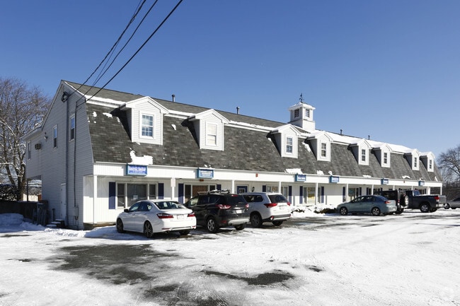
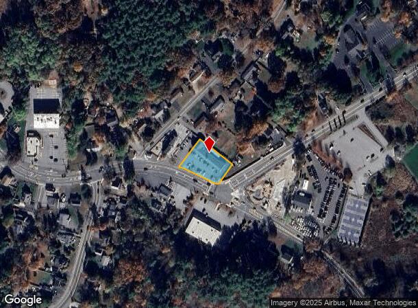
465 Nashua Rd, Dracut, MA 01826
This Property Is For Sale
NEARBY LISTINGS FOR SALE OR LEASE
Property Detail
465 Nashua Rd
Officecondo
Middlesex
X
Massachusetts
25017C0136F
2.7
2025
Groton/Townsend
2025
Boston
314101
Boston-Cambridge-Newton, MA-NH
1,329 SF
DRAC-000031-000022-000002-000007
DEMOGRAPHICS near 465 Nashua Rd
1 Mile
3 Mile
5 Mile
2024 Total Population
8,279
56,281
174,002
2029 Population
8,174
55,443
171,884
Pop Growth 2024-2029
(1.27%)
(1.49%)
(1.22%)
Average Age
42
40
39
2024 Total Households
3,099
20,443
63,909
HH Growth 2024-2029
(1.36%)
(1.60%)
(1.22%)
Median Household Inc
$95,073
$86,267
$81,153
Avg Household Size
2.60
2.60
2.60
2024 Avg HH Vehicles
2.00
2.00
2.00
Median Home Value
$380,072
$383,117
$397,723
Median Year Built
1980
1974
1965
Nearby Places
- Restaurants
- Banks
- Shops
- Fitness
- Groceries
PUBLIC TRANSPORTATION
COMMUTER RAIL
Lowell (Lowell Line - Massachusetts Bay Transportation Authority Commuter Rail (Purple Line))
DRIVE
WALK
Distance
Lowell (Lowell Line - Massachusetts Bay Transportation Authority Commuter Rail (Purple Line))
9 min
4.3 mi
North Billerica (Lowell Line - Massachusetts Bay Transportation Authority Commuter Rail (Purple Line))
DRIVE
WALK
Distance
North Billerica (Lowell Line - Massachusetts Bay Transportation Authority Commuter Rail (Purple Line))
18 min
8.5 mi
AIRPORT
Manchester Boston Regional
DRIVE
WALK
Distance
Manchester Boston Regional
41 min
24.5 mi
General Edward Lawrence Logan International
DRIVE
WALK
Distance
General Edward Lawrence Logan International
54 min
34.5 mi
Worcester Regional
DRIVE
WALK
Distance
Worcester Regional
68 min
49.3 mi
Nearby Properties
Address
Land Use
TOTAL SIZE
Lot Size
Zoning
Address
Land Use
TOTAL SIZE
Lot Size
Zoning
9.73 AC
INST
Address
Land Use
TOTAL SIZE
Lot Size
Zoning
70.20 AC
R3
Address
Land Use
TOTAL SIZE
Lot Size
Zoning
30,744 SF
31.28 AC
INST
Address
Land Use
TOTAL SIZE
Lot Size
Zoning
23,251 SF
18.20 AC
SMF
Address
Land Use
TOTAL SIZE
Lot Size
Zoning
2.15 AC
INST
Address
Land Use
TOTAL SIZE
Lot Size
Zoning
59.09 AC
SSF
Address
Land Use
TOTAL SIZE
Lot Size
Zoning
68.15 AC
R1
Address
Land Use
TOTAL SIZE
Lot Size
Zoning
10.48 AC
INST
Address
Land Use
TOTAL SIZE
Lot Size
Zoning
2.62 AC
INST
Address
Land Use
TOTAL SIZE
Lot Size
Zoning
7.25 AC
INST
Address
Land Use
TOTAL SIZE
Lot Size
Zoning
63,768 SF
8.83 AC
SMU
Address
Land Use
TOTAL SIZE
Lot Size
Zoning
33.01 AC
R3
Address
Land Use
TOTAL SIZE
Lot Size
Zoning
44.39 AC
SMU
Address
Land Use
TOTAL SIZE
Lot Size
Zoning
45.10 AC
R1
Address
Land Use
TOTAL SIZE
Lot Size
Zoning
8.30 AC
B3
Address
Land Use
TOTAL SIZE
Lot Size
Zoning
119,372 SF
1.74 AC
INST
Address
Land Use
TOTAL SIZE
Lot Size
Zoning
73,965 SF
1.33 AC
TTF
Address
Land Use
TOTAL SIZE
Lot Size
Zoning
3,822 SF
1.88 AC
INST
Address
Land Use
TOTAL SIZE
Lot Size
Zoning
177.27 AC
R1
Address
Land Use
TOTAL SIZE
Lot Size
Zoning
134,300 SF
5.58 AC
INST
Address
Land Use
TOTAL SIZE
Lot Size
Zoning
106,077 SF
1.80 AC
TSF
Address
Land Use
TOTAL SIZE
Lot Size
Zoning
83,300 SF
2.31 AC
UMF
Address
Land Use
TOTAL SIZE
Lot Size
Zoning
53,811 SF
4.51 AC
TMUOTHR
Address
Land Use
TOTAL SIZE
Lot Size
Zoning
91,202 SF
12.65 AC
SMU
Address
Land Use
TOTAL SIZE
Lot Size
Zoning
72,223 SF
1.72 AC
TMF
Address
Land Use
TOTAL SIZE
Lot Size
Zoning
4.33 AC
R3
Address
Land Use
TOTAL SIZE
Lot Size
Zoning
42,419 SF
2.80 AC
SSF
Address
Land Use
TOTAL SIZE
Lot Size
Zoning
60,226 SF
2.07 AC
INST
Address
Land Use
TOTAL SIZE
Lot Size
Zoning
50,000 SF
33.40 AC
IA
Address
Land Use
TOTAL SIZE
Lot Size
Zoning
8.20 AC
SSF
The World's #1 Commercial Real Estate Marketplace
Connect with us
© 2025 CoStar Group
The information above has been obtained from sources believed reliable. While we do not doubt its accuracy we have not verified it and make no guarantee, warranty or representation about it. It is your responsibility to independently confirm its accuracy and completeness. Any projections, opinions, assumptions, or estimates used are for example only and do not represent the current or future performance of the property. The value of this transaction to you depends on tax and other factors which should be evaluated by your tax, financial, and legal advisors. You and your advisors should conduct a careful, independent investigation of the property to determine to your satisfaction the suitability of the property for your needs.