Property Record
4650 N 35Th Ave, Phoenix, AZ 85017
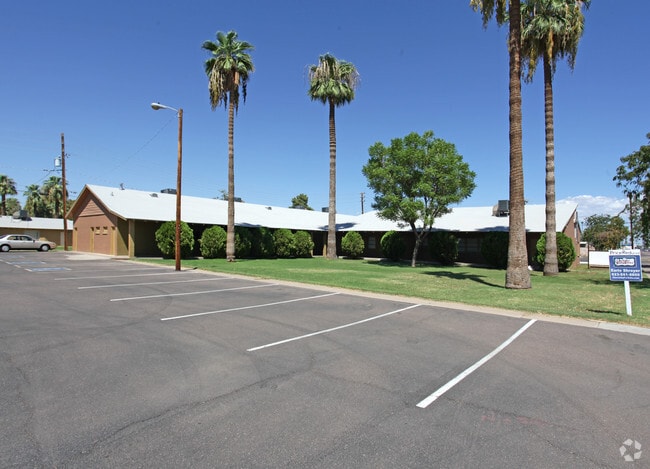

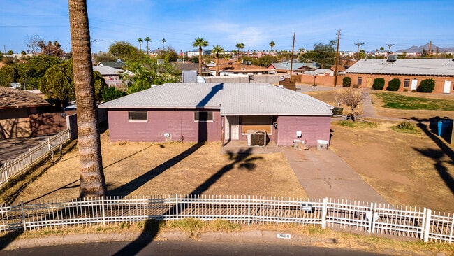
Property Detail
4650 N 35Th Ave
107-07-007A
GRAND MISSION HOMES MCR 47/34
Religious
Maricopa
R-6
Arizona
C and X Area of minimal flood hazard, usually depicted on FIRMs as above the 500-year flood level.
1
0
1.88 AC
2025
Northwest Phoenix
109200
Phoenix
13,678 SF
Phoenix-Mesa-Chandler, AZ
NEARBY LISTINGS FOR SALE OR LEASE
-
-
View all Phoenix listings for sale on LoopNet.com
DEMOGRAPHICS near 4650 N 35Th Ave
1 mile
3 mile
5 mile
2025 Total Population
28,046
212,715
533,461
2030 Population
28,675
218,971
552,214
Pop Growth 2025-2030
+ 2.24%
+ 2.94%
+ 3.52%
Average Age
30
34
35
2025 Total Households
5,997
66,070
183,349
HH Growth 2025-2030
+ 3.13%
+ 3.17%
+ 3.87%
Median Household Inc
$49,538
$55,566
$60,404
Avg Household Size
3.20
2.90
2.70
2025 Avg HH Vehicles
2.00
2.00
2.00
Median Home Value
$292,379
$316,041
$353,351
Median Year Built
1969
1969
1973
Nearby Places
Map Layers
Map Styles
 Street
 Aerial
Layers
 Traffic
 Biking
Places
Listings with unknown addresses are not visible on the map
- Restaurants
- Banks
- Shops
- Fitness
- Groceries
PUBLIC TRANSPORTATION
AIRPORT
Phoenix Sky Harbor International
Drive
Walk
Distance
Phoenix Sky Harbor International
20 min
11.6 mi
Phoenix-Mesa Gateway
Drive
Walk
Distance
Phoenix-Mesa Gateway
53 min
38.7 mi
SALE & LEASE HISTORY
LISTING DATE
SALE/LEASE

Mar 04, 2025
For Sale
Nearby Properties
Address
Land Use
TOTAL SIZE
Lot Size
Zoning
Address
Land Use
TOTAL SIZE
Lot Size
Zoning
96,183 SF
11.04 AC
R-6
Address
Land Use
TOTAL SIZE
Lot Size
Zoning
69,542 SF
4.92 AC
I-P
Address
Land Use
TOTAL SIZE
Lot Size
Zoning
956,022 SF
14.86 AC
Address
Land Use
TOTAL SIZE
Lot Size
Zoning
496,222 SF
29.53 AC
C-R
Address
Land Use
TOTAL SIZE
Lot Size
Zoning
42,631 SF
2.90 AC
A-2
Address
Land Use
TOTAL SIZE
Lot Size
Zoning
281,038 SF
7.71 AC
Address
Land Use
TOTAL SIZE
Lot Size
Zoning
32,600 SF
2.38 AC
R-5
Address
Land Use
TOTAL SIZE
Lot Size
Zoning
337,487 SF
39 AC
R-6
Address
Land Use
TOTAL SIZE
Lot Size
Zoning
474,952 SF
13.68 AC
C-C
Address
Land Use
TOTAL SIZE
Lot Size
Zoning
629,928 SF
41.37 AC
Address
Land Use
TOTAL SIZE
Lot Size
Zoning
449,802 SF
27.08 AC
A-1
Address
Land Use
TOTAL SIZE
Lot Size
Zoning
464,812 SF
35.43 AC
R16
Address
Land Use
TOTAL SIZE
Lot Size
Zoning
25.91 AC
A1
Address
Land Use
TOTAL SIZE
Lot Size
Zoning
350,874 SF
28.66 AC
C-C
Address
Land Use
TOTAL SIZE
Lot Size
Zoning
211,015 SF
9.59 AC
R-6
Address
Land Use
TOTAL SIZE
Lot Size
Zoning
194,523 SF
37.27 AC
R-6
Address
Land Use
TOTAL SIZE
Lot Size
Zoning
18,522 SF
1.69 AC
R-6
Address
Land Use
TOTAL SIZE
Lot Size
Zoning
208,563 SF
9.78 AC
R-6
Address
Land Use
TOTAL SIZE
Lot Size
Zoning
250,180 SF
16.16 AC
C-C
Address
Land Use
TOTAL SIZE
Lot Size
Zoning
132,597 SF
59.45 AC
C-2
Address
Land Use
TOTAL SIZE
Lot Size
Zoning
18,296 SF
0.93 AC
I-P
Address
Land Use
TOTAL SIZE
Lot Size
Zoning
398,829 SF
11.66 AC
M-H
Address
Land Use
TOTAL SIZE
Lot Size
Zoning
367,133 SF
17.88 AC
IND.PK.
Address
Land Use
TOTAL SIZE
Lot Size
Zoning
139,343 SF
10.13 AC
R-6
Address
Land Use
TOTAL SIZE
Lot Size
Zoning
114,671 SF
13.28 AC
R-6
Address
Land Use
TOTAL SIZE
Lot Size
Zoning
120,680 SF
19.15 AC
A-1
Address
Land Use
TOTAL SIZE
Lot Size
Zoning
116,276 SF
11.58 AC
R-6
Address
Land Use
TOTAL SIZE
Lot Size
Zoning
259,062 SF
21.39 AC
C-R
Address
Land Use
TOTAL SIZE
Lot Size
Zoning
208,448 SF
19.04 AC
C-C
The World's #1 Commercial Real Estate Marketplace
Connect with us
© 2026 CoStar Group
The information above has been obtained from sources believed reliable. While we do not doubt its accuracy we have not verified it and make no guarantee, warranty or representation about it. It is your responsibility to independently confirm its accuracy and completeness. Any projections, opinions, assumptions, or estimates used are for example only and do not represent the current or future performance of the property. The value of this transaction to you depends on tax and other factors which should be evaluated by your tax, financial, and legal advisors. You and your advisors should conduct a careful, independent investigation of the property to determine to your satisfaction the suitability of the property for your needs.