Property Record
46500 Bermont Rd, Punta Gorda, FL 33982
NEARBY LISTINGS FOR SALE OR LEASE
-
-
View all Punta Gorda listings for sale on LoopNet.com
Property Detail
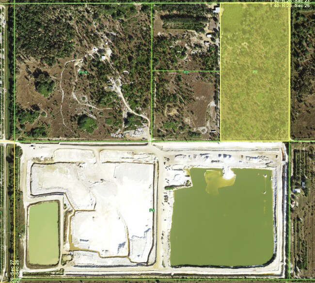
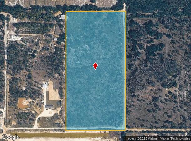
46500 Bermont Rd
402626100004
26 40 26 20A M/L P-2 E1/2 OF NE1/4 OF NW1/4 408-176 435-67 568-1682 568-1684 692/608 1068-1717(1/2 INT EA) 2238/1524-1525-1526-1527 2633/1320 E4616/1676
Agriculturalland
Charlotte
X
Florida
12015C0325G
20 AC
2024
Charlotte County
2025
Southwest Florida
010200
Punta Gorda, FL
DEMOGRAPHICS near 46500 Bermont Rd
1 Mile
3 Mile
5 Mile
2024 Total Population
21
594
769
2029 Population
26
750
971
Pop Growth 2024-2029
+ 23.81%
+ 26.26%
+ 26.27%
Average Age
45
46
46
2024 Total Households
8
241
312
HH Growth 2024-2029
+ 37.50%
+ 26.14%
+ 26.28%
Median Household Inc
$112,500
$90,789
$89,999
Avg Household Size
2.10
2.50
2.40
2024 Avg HH Vehicles
2.00
2.00
2.00
Median Home Value
$325,000
$361,193
$360,919
Median Year Built
2010
2010
2010
Nearby Places
Map Layers
Map Styles
 Street
 Aerial
- Restaurants
- Banks
- Shops
- Fitness
- Groceries
PUBLIC TRANSPORTATION
AIRPORT
Punta Gorda
DRIVE
WALK
Distance
Punta Gorda
55 min
26.1 mi
Freight Ports
Port Manatee
DRIVE
WALK
Distance
Port Manatee
128 min
86.9 mi
SALE & LEASE HISTORY
LISTING DATE
SALE/LEASE

May 30, 2024
For Sale
Nearby Properties
Address
Land Use
TOTAL SIZE
Lot Size
Zoning
Address
Land Use
TOTAL SIZE
Lot Size
Zoning
7,808 SF
520 AC
AG
Address
Land Use
TOTAL SIZE
Lot Size
Zoning
1,680 SF
167.33 AC
AG
Address
Land Use
TOTAL SIZE
Lot Size
Zoning
11,834 SF
480.25 AC
AG
Address
Land Use
TOTAL SIZE
Lot Size
Zoning
20,341 SF
2,513.46 AC
AG
Address
Land Use
TOTAL SIZE
Lot Size
Zoning
2,070 SF
635 AC
AG
Address
Land Use
TOTAL SIZE
Lot Size
Zoning
276 SF
706.59 AC
AG
Address
Land Use
TOTAL SIZE
Lot Size
Zoning
23,959 SF
655.02 AC
AG
Address
Land Use
TOTAL SIZE
Lot Size
Zoning
8,618 SF
649.27 AC
AG
Address
Land Use
TOTAL SIZE
Lot Size
Zoning
744 SF
100 AC
AG
Address
Land Use
TOTAL SIZE
Lot Size
Zoning
8,965 SF
232.50 AC
AG
Address
Land Use
TOTAL SIZE
Lot Size
Zoning
13,596 SF
200 AC
AG
Address
Land Use
TOTAL SIZE
Lot Size
Zoning
880 SF
600 AC
AG
Address
Land Use
TOTAL SIZE
Lot Size
Zoning
1,474 SF
200 AC
AG
Address
Land Use
TOTAL SIZE
Lot Size
Zoning
10,544 SF
320 AC
EM
Address
Land Use
TOTAL SIZE
Lot Size
Zoning
160 AC
AG
Address
Land Use
TOTAL SIZE
Lot Size
Zoning
118.53 AC
AG
Address
Land Use
TOTAL SIZE
Lot Size
Zoning
4,320 SF
18.93 AC
AG
Address
Land Use
TOTAL SIZE
Lot Size
Zoning
2,984 SF
10 AC
AG
Address
Land Use
TOTAL SIZE
Lot Size
Zoning
40.74 AC
AG
Address
Land Use
TOTAL SIZE
Lot Size
Zoning
3,029 SF
10 AC
AG
Address
Land Use
TOTAL SIZE
Lot Size
Zoning
2,980 SF
110 AC
AG
Address
Land Use
TOTAL SIZE
Lot Size
Zoning
13,456 SF
80 AC
AG
Address
Land Use
TOTAL SIZE
Lot Size
Zoning
98.70 AC
AG
Address
Land Use
TOTAL SIZE
Lot Size
Zoning
30 AC
AG
Address
Land Use
TOTAL SIZE
Lot Size
Zoning
1,105 SF
80 AC
AG
Address
Land Use
TOTAL SIZE
Lot Size
Zoning
4,884 SF
10 AC
AG
Address
Land Use
TOTAL SIZE
Lot Size
Zoning
2,624 SF
10 AC
AG
Address
Land Use
TOTAL SIZE
Lot Size
Zoning
3,535 SF
30 AC
AG
Address
Land Use
TOTAL SIZE
Lot Size
Zoning
2,879 SF
19.60 AC
AG
Address
Land Use
TOTAL SIZE
Lot Size
Zoning
160 AC
EM
The World's #1 Commercial Real Estate Marketplace
Connect with us
© 2026 CoStar Group
The information above has been obtained from sources believed reliable. While we do not doubt its accuracy we have not verified it and make no guarantee, warranty or representation about it. It is your responsibility to independently confirm its accuracy and completeness. Any projections, opinions, assumptions, or estimates used are for example only and do not represent the current or future performance of the property. The value of this transaction to you depends on tax and other factors which should be evaluated by your tax, financial, and legal advisors. You and your advisors should conduct a careful, independent investigation of the property to determine to your satisfaction the suitability of the property for your needs.