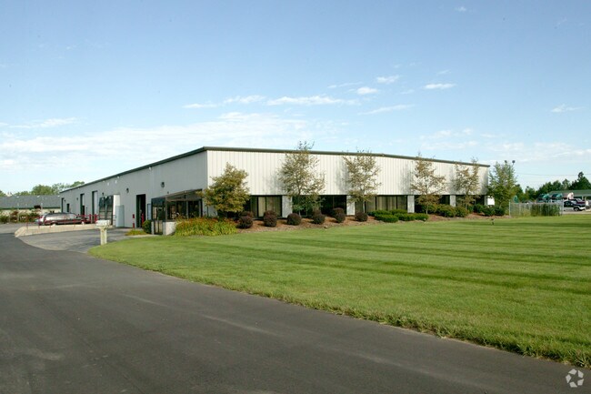
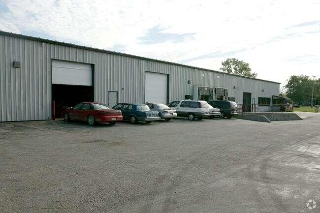
Property Record
4652 Division St, Wayland, MI 49348

Property Detail
4652 Division St
05-001-026-12
COM 1220.49' S OF E 1/4 PST TH S 200' TH N 88 DEG 21 W 454' TH N 200' TH S 88 DEG 21 E 454' TO POB SEC 1 T4N R12W TAX MAP:
Distributionwarehouseregional
Allegan
B and X Area of moderate flood hazard, usually the area between the limits of the 100-year and 500-year floods.
Michigan
2024
2.09 AC
2025
Outlying Allegan County
030403
West Michigan
24,000 SF
Holland, MI
NEARBY LISTINGS FOR SALE OR LEASE
DEMOGRAPHICS near 4652 Division St
1 mile
3 mile
5 mile
2025 Total Population
117
6,438
28,491
2030 Population
119
6,594
29,253
Pop Growth 2025-2030
+ 1.71%
+ 2.42%
+ 2.67%
Average Age
37
38
38
2025 Total Households
39
2,101
9,659
HH Growth 2025-2030
0.00%
+ 2.33%
+ 2.69%
Median Household Inc
$89,999
$93,571
$102,996
Avg Household Size
3.00
3.00
2.90
2025 Avg HH Vehicles
2.00
2.00
2.00
Median Home Value
$288,888
$336,236
$345,281
Median Year Built
1998
1995
1994
Nearby Places
Map Layers
Map Styles
 Street
 Aerial
Layers
 Traffic
 Biking
Places
Listings with unknown addresses are not visible on the map
- Restaurants
- Banks
- Shops
- Fitness
- Groceries
PUBLIC TRANSPORTATION
AIRPORT
Gerald R Ford International
Drive
Walk
Distance
Gerald R Ford International
25 min
15.3 mi
Nearby Properties
Address
Land Use
TOTAL SIZE
Lot Size
Zoning
Address
Land Use
TOTAL SIZE
Lot Size
Zoning
58.30 AC
RA
Address
Land Use
TOTAL SIZE
Lot Size
Zoning
119.76 AC
Address
Land Use
TOTAL SIZE
Lot Size
Zoning
132,905 SF
58.60 AC
Address
Land Use
TOTAL SIZE
Lot Size
Zoning
22.37 AC
Address
Land Use
TOTAL SIZE
Lot Size
Zoning
54,240 SF
36.50 AC
Address
Land Use
TOTAL SIZE
Lot Size
Zoning
56,370 SF
6.54 AC
Address
Land Use
TOTAL SIZE
Lot Size
Zoning
Address
Land Use
TOTAL SIZE
Lot Size
Zoning
172,000 SF
9.60 AC
Address
Land Use
TOTAL SIZE
Lot Size
Zoning
Address
Land Use
TOTAL SIZE
Lot Size
Zoning
196,250 SF
24.59 AC
Address
Land Use
TOTAL SIZE
Lot Size
Zoning
44,250 SF
37.35 AC
Address
Land Use
TOTAL SIZE
Lot Size
Zoning
Address
Land Use
TOTAL SIZE
Lot Size
Zoning
145,000 SF
11.85 AC
Address
Land Use
TOTAL SIZE
Lot Size
Zoning
2,351 SF
139 AC
AGRICUL
Address
Land Use
TOTAL SIZE
Lot Size
Zoning
78,120 SF
4.13 AC
Address
Land Use
TOTAL SIZE
Lot Size
Zoning
121,666 SF
16.04 AC
Address
Land Use
TOTAL SIZE
Lot Size
Zoning
81,744 SF
40.27 AC
RA
Address
Land Use
TOTAL SIZE
Lot Size
Zoning
31,890 SF
14 AC
Address
Land Use
TOTAL SIZE
Lot Size
Zoning
32,825 SF
5.05 AC
Address
Land Use
TOTAL SIZE
Lot Size
Zoning
35,400 SF
Address
Land Use
TOTAL SIZE
Lot Size
Zoning
79,768 SF
13.40 AC
Address
Land Use
TOTAL SIZE
Lot Size
Zoning
60,188 SF
4.80 AC
D1PUD
Address
Land Use
TOTAL SIZE
Lot Size
Zoning
24,999 SF
8.79 AC
Address
Land Use
TOTAL SIZE
Lot Size
Zoning
46,060 SF
11.88 AC
Address
Land Use
TOTAL SIZE
Lot Size
Zoning
80,280 SF
12.73 AC
Address
Land Use
TOTAL SIZE
Lot Size
Zoning
72,175 SF
4.30 AC
Address
Land Use
TOTAL SIZE
Lot Size
Zoning
197.92 AC
Address
Land Use
TOTAL SIZE
Lot Size
Zoning
Address
Land Use
TOTAL SIZE
Lot Size
Zoning
22,495 SF
B1-PUD
Address
Land Use
TOTAL SIZE
Lot Size
Zoning
12,000 SF
6.47 AC
The World's #1 Commercial Real Estate Marketplace
Connect with us
© 2026 CoStar Group
The information above has been obtained from sources believed reliable. While we do not doubt its accuracy we have not verified it and make no guarantee, warranty or representation about it. It is your responsibility to independently confirm its accuracy and completeness. Any projections, opinions, assumptions, or estimates used are for example only and do not represent the current or future performance of the property. The value of this transaction to you depends on tax and other factors which should be evaluated by your tax, financial, and legal advisors. You and your advisors should conduct a careful, independent investigation of the property to determine to your satisfaction the suitability of the property for your needs.