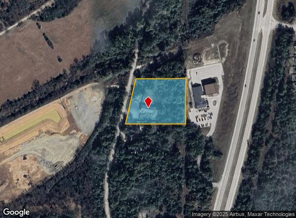
Property Record
4655 S 112Th West Ave, Sand Springs, OK 74063
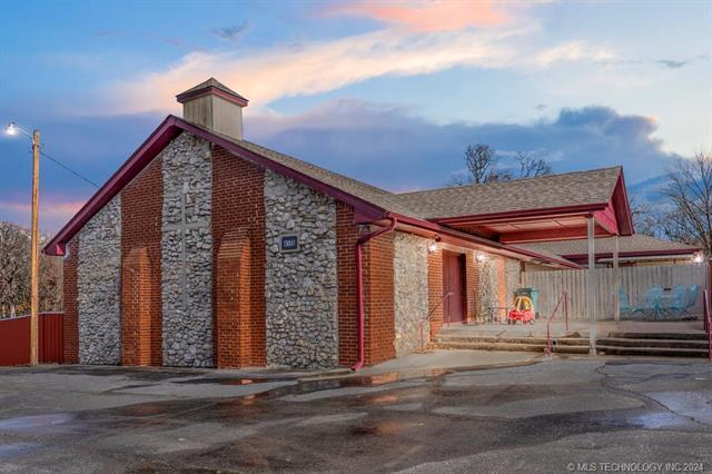
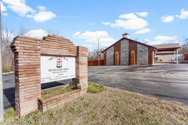
This Property Is For Sale
NEARBY LISTINGS FOR SALE OR LEASE
-
-
View all Sand Springs listings for sale on LoopNet.com
Property Detail
4655 S 112Th West Ave
99127-91-27-21040
Unplatted
Daycare
BEG 199.33S NEC NE SE TH W334.97 SW303 E401.70 N295.70 POB SEC 27 19 11 2.73ACS
AE
Tulsa
40143C0326L
Oklahoma
2025
2.73 AC
2025
West
009403
Tulsa
4,853 SF
Tulsa, OK
DEMOGRAPHICS near 4655 S 112Th West Ave
1 Mile
3 Mile
5 Mile
2024 Total Population
6,599
15,567
39,833
2029 Population
6,813
16,074
41,382
Pop Growth 2024-2029
+ 3.24%
+ 3.26%
+ 3.89%
Average Age
40
41
40
2024 Total Households
2,559
6,000
15,560
HH Growth 2024-2029
+ 3.24%
+ 3.30%
+ 3.96%
Median Household Inc
$71,290
$71,091
$60,571
Avg Household Size
2.60
2.60
2.50
2024 Avg HH Vehicles
2.00
2.00
2.00
Median Home Value
$158,925
$176,045
$160,413
Median Year Built
1982
1982
1975
Nearby Places
- Restaurants
- Banks
- Shops
- Fitness
- Groceries
PUBLIC TRANSPORTATION
AIRPORT
Tulsa International
DRIVE
WALK
Distance
Tulsa International
30 min
19.0 mi
Freight Ports
DRIVE
WALK
Distance
39 min
28.2 mi
Nearby Properties
Address
Land Use
TOTAL SIZE
Lot Size
Zoning
Address
Land Use
TOTAL SIZE
Lot Size
Zoning
142,214 SF
98.12 AC
AG
Address
Land Use
TOTAL SIZE
Lot Size
Zoning
45,993 SF
9.16 AC
IH
Address
Land Use
TOTAL SIZE
Lot Size
Zoning
15,747 SF
2.50 AC
CM
Address
Land Use
TOTAL SIZE
Lot Size
Zoning
45,095 SF
46.36 AC
AG
Address
Land Use
TOTAL SIZE
Lot Size
Zoning
45,125 SF
7.05 AC
RM1
Address
Land Use
TOTAL SIZE
Lot Size
Zoning
22,078 SF
5.08 AC
CS
Address
Land Use
TOTAL SIZE
Lot Size
Zoning
41,456 SF
2.39 AC
RS2
Address
Land Use
TOTAL SIZE
Lot Size
Zoning
315,085 SF
113.93 AC
IM
Address
Land Use
TOTAL SIZE
Lot Size
Zoning
108,900 SF
6.82 AC
IM
Address
Land Use
TOTAL SIZE
Lot Size
Zoning
44,238 SF
9.11 AC
IH
Address
Land Use
TOTAL SIZE
Lot Size
Zoning
207,138 SF
14.17 AC
CG
Address
Land Use
TOTAL SIZE
Lot Size
Zoning
33,195 SF
2.60 AC
RS2
Address
Land Use
TOTAL SIZE
Lot Size
Zoning
61,088 SF
57.14 AC
IM
Address
Land Use
TOTAL SIZE
Lot Size
Zoning
22,350 SF
14.91 AC
AG
Address
Land Use
TOTAL SIZE
Lot Size
Zoning
17,012 SF
3.32 AC
CS
Address
Land Use
TOTAL SIZE
Lot Size
Zoning
16,456 SF
5.67 AC
RE
Address
Land Use
TOTAL SIZE
Lot Size
Zoning
12,306 SF
2.10 AC
AG
Address
Land Use
TOTAL SIZE
Lot Size
Zoning
21,694 SF
3.99 AC
AG
Address
Land Use
TOTAL SIZE
Lot Size
Zoning
8,784 SF
7.93 AC
CG
Address
Land Use
TOTAL SIZE
Lot Size
Zoning
21,349 SF
2.10 AC
RS2
Address
Land Use
TOTAL SIZE
Lot Size
Zoning
4,200 SF
1.73 AC
RE
Address
Land Use
TOTAL SIZE
Lot Size
Zoning
9,060 SF
2.05 AC
CS
Address
Land Use
TOTAL SIZE
Lot Size
Zoning
137,923 SF
37.46 AC
IM
Address
Land Use
TOTAL SIZE
Lot Size
Zoning
7,000 SF
0.16 AC
CH
Address
Land Use
TOTAL SIZE
Lot Size
Zoning
2,535 SF
79.75 AC
AG
Address
Land Use
TOTAL SIZE
Lot Size
Zoning
13,964 SF
3 AC
RS1
Address
Land Use
TOTAL SIZE
Lot Size
Zoning
8,400 SF
8.86 AC
RE
Address
Land Use
TOTAL SIZE
Lot Size
Zoning
42,300 SF
1.48 AC
CM
Address
Land Use
TOTAL SIZE
Lot Size
Zoning
13,953 SF
3.74 AC
RE
Address
Land Use
TOTAL SIZE
Lot Size
Zoning
11,682 SF
2.07 AC
AG
The World's #1 Commercial Real Estate Marketplace
Connect with us
© 2025 CoStar Group
The information above has been obtained from sources believed reliable. While we do not doubt its accuracy we have not verified it and make no guarantee, warranty or representation about it. It is your responsibility to independently confirm its accuracy and completeness. Any projections, opinions, assumptions, or estimates used are for example only and do not represent the current or future performance of the property. The value of this transaction to you depends on tax and other factors which should be evaluated by your tax, financial, and legal advisors. You and your advisors should conduct a careful, independent investigation of the property to determine to your satisfaction the suitability of the property for your needs.